Weather Forecast: Rainfall Likely to Continue Across Several States From August 28

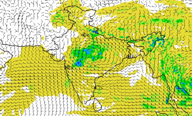
India Meteorological Department (IMD) has forecast continued rainfall activity across several parts of the country from August 28 onwards, with heavy to very heavy rainfall likely in parts of central, eastern, northeastern and Himalayan India. The extended-range forecast indicates that while some regions will experience enhanced monsoon activity, overall rainfall across the country is likely to remain below normal during the week.
The IMD’s latest assessment covers the period from August 27 to September 9, 2026. A low-pressure area is currently lying over southeast Uttar Pradesh and adjoining areas, while another low-pressure system is likely to develop over the northwest Bay of Bengal around August 29 under the influence of an upper-air cyclonic circulation.
Rainfall Forecast From August 28
From August 28, rainfall is expected to remain active over several states. In central India, East Madhya Pradesh is likely to receive fairly widespread to widespread rainfall during August 27-29, with isolated heavy rainfall on August 28 and 29. Chhattisgarh is also likely to experience widespread rainfall through September 2, with isolated heavy rainfall during the period.
Vidarbha is forecast to receive fairly widespread to widespread rainfall on August 28, while rainfall activity is expected to return around September 2. These conditions could bring temporary relief from dry spells but may also increase the risk of waterlogging in vulnerable areas.
Uttar Pradesh, Bihar and Jharkhand
The weather system over southeast Uttar Pradesh and its movement towards central India will continue to influence rainfall during the coming days.
East Uttar Pradesh is likely to receive isolated heavy rainfall during August 27-28 and again during August 31-September 2. West Uttar Pradesh may also see isolated heavy rainfall on September 2. The IMD had earlier forecast isolated very heavy rainfall over West Uttar Pradesh on August 27.
In Bihar, fairly widespread to widespread rainfall is expected on August 28-29. Isolated heavy rainfall is likely from August 27-30. Jharkhand is likely to receive widespread rainfall through September 2, with isolated heavy rainfall during August 27-31.
The IMD has also warned of moderate to severe lightning activity over Bihar on August 28 and 29, requiring caution during thunderstorms.
Odisha to Remain Rain-Active
Odisha is expected to remain one of the important rainfall zones during the period. Fairly widespread to widespread rainfall is likely through September 2, while isolated heavy rainfall is forecast on September 1 and 2.
More significantly, the IMD has forecast isolated very heavy rainfall over Odisha from August 27 to 31. This means rainfall activity is likely to remain strong over parts of the state through the weekend and into the beginning of next week.
The weather system expected to form over the northwest Bay of Bengal around August 29 could further influence rainfall over Odisha and adjoining eastern states.
Northeast India Faces Heavy Rain Risk
Rainfall will also remain widespread across the northeastern states.
Arunachal Pradesh, Nagaland, Manipur, Mizoram and Tripura are likely to experience fairly widespread to widespread rainfall through September 2. Assam and Meghalaya are expected to see widespread rainfall particularly during August 29-31.
Isolated heavy rainfall is likely over Arunachal Pradesh and Assam-Meghalaya during August 27-29 and again from August 31 to September 2. Nagaland, Manipur, Mizoram and Tripura may experience isolated heavy rainfall during August 27-31 and again on September 2.
The IMD has specifically forecast isolated very heavy rainfall over Arunachal Pradesh and Assam-Meghalaya on August 30.
Himalayan Region to See Increased Rainfall
The western Himalayan region is also likely to experience a fresh spell of rainfall around the beginning of September.
Uttarakhand is forecast to receive widespread rainfall through September 2, while Himachal Pradesh is likely to see fairly widespread to widespread rainfall from August 30 to September 2. Jammu and Kashmir, Ladakh and adjoining areas are expected to receive widespread rainfall during August 31 and September 1.
Isolated heavy rainfall is likely over Himachal Pradesh from August 31 to September 2 and over Uttarakhand from August 30 to September 2. These conditions could raise the possibility of localised waterlogging and landslides in vulnerable hilly areas.
West Coast and Southern Peninsula
Along the west coast, Konkan and Goa are likely to experience fairly widespread to widespread rainfall through September 2. Coastal Karnataka is also expected to receive widespread rainfall during the same period.
Kerala and Mahe, along with Lakshadweep, are likely to receive fairly widespread to widespread rainfall through August 30. The IMD has forecast isolated heavy rainfall over Kerala and Mahe on August 27.
In the southern peninsula, strong surface winds are likely over North Interior Karnataka and South Interior Karnataka from August 27-29, while Coastal Andhra Pradesh, Yanam and Rayalaseema may experience strong surface winds through August 31.
Weather Outlook for September 3-9
The IMD expects another important weather system to develop during the second week of the forecast period. A fresh upper-air cyclonic circulation is likely to form over the north Bay of Bengal during the first half of September 3-9, under whose influence a low-pressure area may develop over the same region.
A Western Disturbance is also likely to affect northwest India during the week. The IMD has indicated that the interaction between the westerly trough and the eastward-moving low-pressure area could influence weather conditions over parts of the country.
During September 3-9, light to moderate fairly widespread to widespread rainfall is expected over parts of the Western Himalayan region, with isolated heavy rainfall possible over Jammu and Kashmir, Himachal Pradesh and Uttarakhand.
Northeast and East India are likely to receive widespread rainfall, with isolated heavy to very heavy rainfall possible over Arunachal Pradesh, Assam and Meghalaya, West Bengal and Sikkim, Odisha, Jharkhand and Bihar.
No Heatwave Expected
Despite variations in rainfall, the IMD has ruled out any heatwave conditions across the country during both forecast weeks.
For August 27-September 2, maximum temperatures are likely to be 2-3°C above normal over some parts of the plains of Northwest India and Northeast India during some or many days. Temperatures elsewhere are expected to remain near normal.
During September 3-9, some parts of the plains of Northwest India may again experience maximum temperatures 2-3°C above normal. However, no heatwave or unusually warm nights are expected anywhere in the country.
Overall Monsoon Rainfall Likely Below Normal
The latest IMD assessment shows that rainfall remained deficient during the previous week. Between August 20 and 26, the country received 19% less rainfall than its Long Period Average. Cumulatively from June 1 to August 26, rainfall over the country was 13% below LPA, placing the season in the below-normal category.
The IMD expects rainfall to remain below normal over the country as a whole during both August 27-September 2 and September 3-9. However, rainfall is expected to be normal to above normal over the Himalayan foothills, East and Central India in the first week, and over East India and adjoining east-central India during the second week.
Weather Systems Driving the Forecast
The current weather pattern is being influenced by a low-pressure area over southeast Uttar Pradesh and adjoining areas, along with the monsoon trough. An upper-air cyclonic circulation over the northwest Bay of Bengal and adjoining West Bengal-north Odisha coast is expected to trigger another low-pressure area around August 29.
The IMD has also forecast a feeble Western Disturbance over northwest India during the week.
The broader atmospheric pattern includes moderate El Niño conditions over the equatorial Pacific, which are expected to strengthen during the remaining Southwest Monsoon season. Neutral Indian Ocean Dipole conditions currently prevail, while some international climate models indicate the possibility of positive IOD conditions developing during September.
IMD Warns of Localised Flooding and Disruption
The IMD has cautioned that heavy rainfall and squally winds may result in localised waterlogging, inundation, flooding of low-lying areas, landslides, mudslides and reduced visibility. Road and rail traffic may also be affected in areas receiving heavy rainfall.
People in areas under heavy-rain and thunderstorm risk have been advised to monitor weather updates and move to safer locations when necessary. During lightning activity, the IMD has advised people to avoid taking shelter under trees, stay away from water bodies and electrical conductors, and disconnect electrical and electronic appliances where appropriate.
Key Forecast Dates
| Date/Period | Major Weather Outlook |
|---|---|
| August 28-29 | Heavy rainfall activity continues over parts of East MP, Bihar and adjoining regions |
| August 29 | Low-pressure area likely to form over northwest Bay of Bengal |
| August 30 | Very heavy rainfall possible over Arunachal Pradesh and Assam-Meghalaya |
| August 30-September 2 | Increased rainfall over Himachal Pradesh and Uttarakhand |
| August 31-September 2 | Rainfall activity likely over Western Himalayan region |
| September 1-2 | Heavy rainfall possible over parts of East MP, Odisha and Uttar Pradesh |
| September 3-9 | Fresh low-pressure system likely over north Bay of Bengal; widespread rain likely over East and Northeast India |
Overall, the IMD forecast points to continued rainfall activity from August 28 onwards, particularly over eastern, central, northeastern and Himalayan regions. While no heatwave is expected, heavy to very heavy rainfall in pockets could create localised flooding, waterlogging and landslide risks. Another low-pressure system expected to develop over the north Bay of Bengal in early September could keep monsoon activity active over eastern and northeastern India.