
Severe Cyclonic Storm Murasu to Cross South Andhra Pradesh Coast Tonight; Chennai Records Heavy Rainfall
The India Meteorological Department (IMD) has issued a Red Message cyclone warning for the Andhra Pradesh and adjoining north Tamil Nadu coasts, forecasting landfall between Nellore and Narsapur, close to Ongole, with wind speeds reaching 120 kmph.

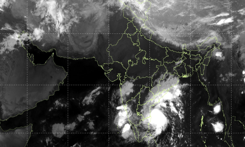
According to the latest IMD bulletin, the cyclone moved west-northwestwards at a speed of approximately 25 kmph during the preceding six hours. At 0530 hours IST on November 2, the system was centred over the Westcentral and adjoining Southwest Bay of Bengal near latitude 13.9°N and longitude 81.8°E.
The cyclone was located approximately 200 km east-northeast of Chennai in Tamil Nadu, 210 km east-southeast of Nellore, 220 km east-southeast of Kavali, 260 km southeast of Ongole and 270 km south-southeast of Machilipatnam in Andhra Pradesh.
Cyclone Murasu Likely to Make Landfall Between Nellore and Narsapur
The IMD has forecast that Severe Cyclonic Storm Murasu is very likely to move northwestwards and cross the south Andhra Pradesh coast as a severe cyclonic storm between midnight on November 2 and the early hours of November 3.
The expected landfall window is between 2330 hours IST on November 2 and 0400 hours IST on November 3. The system is likely to cross the coast between Nellore and Narsapur, close to Ongole.
At the time of landfall, the cyclone is expected to bring maximum sustained wind speeds of 100–110 kmph, with gusts reaching 120 kmph.
The anticipated intensity of the system poses a significant threat to coastal districts of Andhra Pradesh, particularly areas along and near the projected landfall region. Coastal communities, fishermen and disaster management authorities are required to remain alert and follow official weather advisories.
The Red Message indicates the highest level of cyclone warning in the IMD’s warning communication system, highlighting the potential for severe weather conditions and the need for preparedness.
Chennai Records Heavy Rainfall as Cyclone Approaches
Even before the cyclone’s expected landfall, its influence has brought substantial rainfall to several parts of Tamil Nadu, particularly Chennai and surrounding districts.
According to rainfall observations recorded between 0830 hours IST on November 1 and 0530 hours IST on November 2, Nungambakkam in Chennai received 87.5 mm of rainfall, while Meenambakkam recorded 33.3 mm.
Among other conventional observatories, Vellore received 14 mm, Cuddalore recorded 2 mm and Puducherry received 0.2 mm of rainfall.
Automatic Weather Stations (AWS) also reported significant rainfall across the region. Ennore Port in Chennai recorded 101 mm, while Chennai registered 78.5 mm. Virudhunagar received 85.7 mm, and Meenambakkam ISRO recorded 29 mm.
Other significant AWS observations included 28.5 mm at Jaya Engineering College in Tiruvallur, 14.5 mm at VIT Chennai in Chengalpattu, 13.5 mm at Kanchipuram ISRO, 8.5 mm at Mahabalipuram and 5.5 mm at Ranipet. Neyyoor in Kanyakumari district recorded 10.5 mm.
Agricultural and Additional Rainfall Stations Report Heavy Precipitation
Rainfall measurements from agricultural weather stations also highlighted the impact of the approaching cyclone.
TNVASU Madhavaram in Chennai recorded 110.5 mm of rainfall, the highest among the listed agricultural stations. Virinjipuram KVK in Vellore received 1.5 mm, while HRS Pechiparai in Kanyakumari recorded 0.5 mm.
Additional Rainfall Gauge (ARG) stations reported substantial precipitation across Chennai and neighbouring districts. Puzhal in Tiruvallur recorded 79.5 mm, followed by YMCA Nandanam in Chennai at 63.5 mm, Anna University at 59 mm and Taramani at 54 mm.
ACS Medical College in Kanchipuram recorded 36.5 mm, while NIOT Pallikaranai in Chennai received 34.2 mm. Hindustan University in Kanchipuram recorded 13.5 mm, Poonamallee in Tiruvallur received 12 mm and Chemb barambakkam recorded 3 mm.
Other observations included 2.5 mm at Cheyyur in Chengalpattu, 2 mm at Lower Kothaiyar in Kanyakumari, and 0.5 mm each at P.N. Palayam in Coimbatore and Cheyyar in Tiruvannamalai.
Coastal Andhra Pradesh on Alert
With Murasu expected to cross the south Andhra Pradesh coast within the next few hours, the focus has shifted towards the preparedness of coastal districts and the potential impact of strong winds and heavy rainfall.
The cyclone’s projected movement and landfall intensity make the coming hours particularly important for the coastal belt between Nellore and Narsapur.
The IMD continues to monitor the system and issue updates on its movement and intensity. Residents in potentially affected areas should closely follow official advisories from the IMD and local authorities.