Latest IMD Bulletin for Severe Cyclonic Storm NIVAR over southwest Bay of Bengal

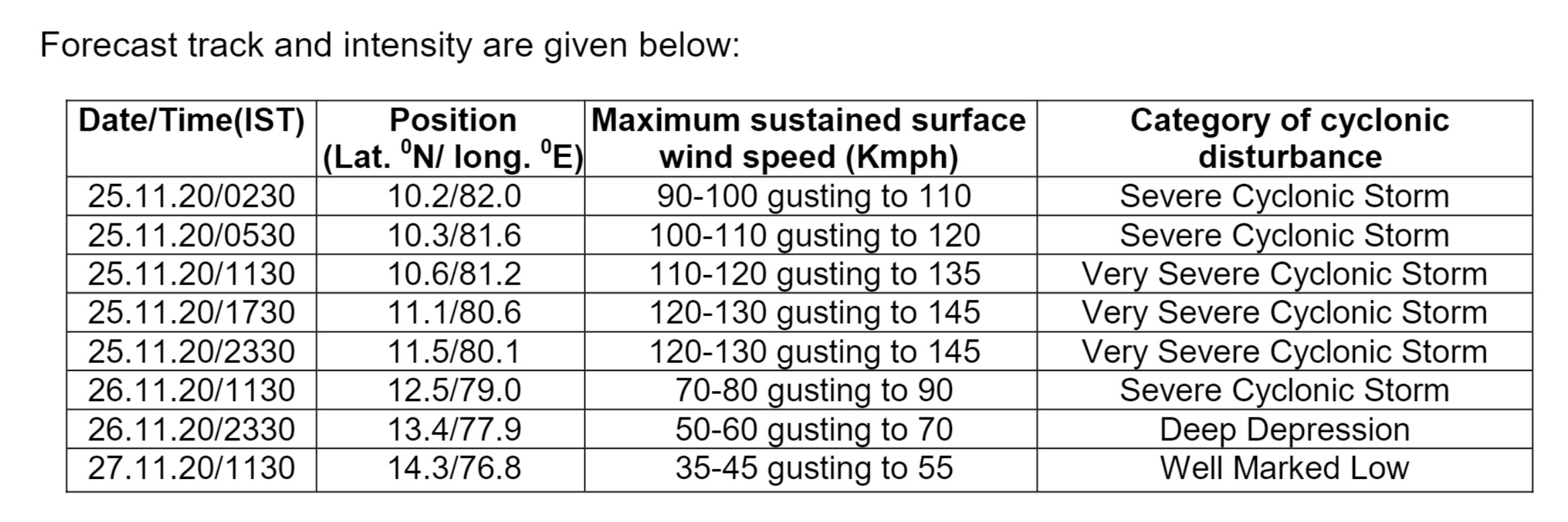
The severe cyclonic storm ‗NIVAR‖ over southwest Bay of Bengal moved west-northwestwards with a speed of 06 kmph during past six hours and lay centred at 0230 hrs IST of 25th November, 2020 over southwest Bay of Bengal near latitude 10.2°N and longitude 82.0°E, about 300 km east-southeast of Cuddalore, about 310 km east southeast of Puducherry and 370 km south southeast of Chennai. It is very likely to intensify further into a very severe cyclonic storm during next 12 hours.
It is very likely to move west-northwestwards for next 06 hours and northwestwards thereafter. It is very likely to cross Tamil Nadu and Puducherry coasts between Karaikal and Mamallapuram around Puducherry during the night of 25th November 2020 as a very severe cyclonic storm with a wind speed of 120-130 kmph gusting to 145 kmph.
Forecast track and intensity are given below:
Warnings:
(i) Rainfall …Fairly widespread to widespread rainfall/thunderstorm activity very likely over coastal and north interior Tamilnadu, Puducherry & Karaikal, south coastal Andhra Pradesh and Rayalaseema during 25 th and 26th November and southeast Telangana during 26th November, 2020. Isolated extremely heavy rainfall activity also very likely over coastal & north interior Tamilnadu & Puducherry (Thanjavur, Tiruvarur, Nagapattinam, Cuddalore, Chennai, Kanchipuram, Chengalpattu, Myladuthirai, Ariyalur, Perambalur, Kallakurchi, Villupuram, Tiruvannamalai, Puducherry and Karaikal districts) during 25 th; over Nellore and Chittoor districts of Andhra Pradesh on 25th and over Rayalseema & southeast Telangana on 26th November, 2020.
(ii) Wind warning
Gale wind speed reaching 90-100 kmph gusting to 110 kmph is prevailing over Southwest Bay of Bengal. It would further increase becoming 110-120 kmph gusting to 135 kmph over the southwest Bay of Bengal from 25th November morning increasing to 120-130 kmph gusting to 145 kmph during noon to night of 25th November.
Squally wind speed reaching 35-45 kmph gusting to 55 kmph is prevailing along & off Tamil Nadu, Puducherry and adjoining South Andhra Pradesh coast and over Gulf of Mannar. It will gradually increase and become gale wind speed reaching 65-75 kmph gusting to 85 kmph from morning of 25th November and 120-130 kmph gusting to 145 kmph along & off coastal districts of north Tamil Nadu and Puducherry (Nagapattinam, Karaikal, Myladuthurai, Cuddalore, Puducherry, Villupuram & Chengalpattu districts; 80-90 gusting to 100 kmph very likely over Tiruvarur, Kanchipuram, Chennai, Tiruvallur districts) during noon to night of 25th November, 2020.
Gale wind speed reaching 65-75 kmph gusting to 85 kmph very likely over adjoining westcentral Bay of Bengal and along & off South Andhra Pradesh (Nellore & Chittoor districts), Gulf of Mannar and along and off south coastal districts of Tamil Nadu during forenoon to night of 25th November, 2020. (iii) Sea condition Sea condition is very high over Southwest Bay of Bengal and rough to very rough along & off Tamil Nadu, Puducherry, south Andhra Pradesh coasts and over Gulf of Mannar. It would gradually become phenomenal over the same area from noon to night of 25th November.
(iv) Strom Surge Warning
Tidal wave of about 1-1.5m height above the astronomical tide is very likely to inundate the low lying areas of north coastal districts of Tamilnadu & Puducherry near the place of landfall. (v) (a) Damage expected over Nagapattinam, Myladuthurai, Cuddalore, , Villupuram & Chengalpattu districts of Tamilnadu and Karaikal & Puducherry:
Total destruction of thatched houses/ extensive damage to kutcha houses. Some damage to old pucca houses. Potential threat from flying objects.
Bending/ uprooting of power and communication poles.
Major damage to Kutcha and and Pucca roads. Flooding of escape routes. Disruption of railways, overhead powerlines and signalling systems. Widespread damage to standing crops, plantations, orchards, falling of green coconuts and tearing of palm fronds. Blowing down of bushy trees like mango.
Small boats, country crafts may get detached from moorings.
Visibility severely affected. (b) Damage expected over Tiruvarur, Kanchipuram, Chennai, Tiruvallaur districts of Tamilnadu and adjoining Andhra Pradesh: Damage to thatched houses/ huts with possibility of roof tops being blown off and unattached metal sheets may fly. Damage to power and communication lines.
Damage to Kutcha and some damage to Pucca roads. Flooding of escape routes.
Breaking of tree branches, uprooting of trees. Severe damage to banana and papaya trees, horticulture and crops & orchards. Large dead limbs blown from trees.
Major damage to coastal crops. Damage to embankments/ salt pans.
(vi) Fishermen Warning & Action Suggested:
Total suspension of fishing operations.
Mobilise evacuation from coastal areas. Coastal hutment dwellers to be moved to safer places.
People in affected areas to remain in safe places and indoors.
Judicious regulation of rail, road and air traffic. Movement in motor boats and small ships unsafe.