Deep Depression Crosses Odisha-West Bengal Coast, IMD Warns of Extremely Heavy Rain

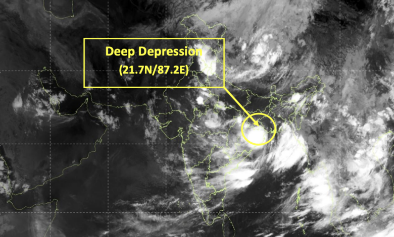
A Deep Depression over the northwest Bay of Bengal crossed the West Bengal–Odisha coast near Digha during the early hours of Tuesday, July 28, triggering widespread rainfall and prompting the India Meteorological Department (IMD) to issue warnings for extremely heavy rain, strong winds, rough sea conditions and possible flash floods across several states.
According to the IMD’s latest national bulletin issued at 9:00 AM IST, the system moved west-northwestwards at a speed of 7 kmph and crossed the coast between 12:30 AM and 1:30 AM IST near Digha. At 5:30 AM, the centre of the Deep Depression was located over north coastal Odisha and adjoining Gangetic West Bengal, about 30 km west-northwest of Digha, 30 km northeast of Balasore, 50 km east-southeast of Baripada, 160 km southeast of Jamshedpur, and 170 km east of Keonjhargarh.
The weather system is expected to continue moving west-northwestwards across north Odisha, south Jharkhand and north Chhattisgarh during the next 24 hours, bringing widespread rainfall and gusty winds across eastern and central India.
Deep Depression: Current Position
|
Parameter |
Details |
|
System |
Deep Depression |
|
Location (5:30 AM IST, July 28) |
North Coastal Odisha & adjoining Gangetic West Bengal |
|
Coast Crossing |
Near Digha between 12:30 AM–1:30 AM IST |
|
Movement |
West-northwest at 7 kmph |
|
Expected Track |
North Odisha → South Jharkhand → North Chhattisgarh |
Extremely Heavy Rainfall Warning
The IMD has warned that Odisha and Chhattisgarh are likely to experience the most intense rainfall on Tuesday, with isolated places receiving extremely heavy rainfall.
Gangetic West Bengal and Jharkhand are also expected to witness heavy to very heavy rain, while the rain belt is forecast to gradually extend into Bihar, Madhya Pradesh and Uttar Pradesh over the next three days.
State-wise Rainfall Forecast
|
State |
Forecast |
|
Odisha |
Heavy to very heavy rain at several places; isolated extremely heavy rainfall on July 28 |
|
Chhattisgarh |
Extremely heavy rainfall on July 28; heavy rain likely till July 31 |
|
Gangetic West Bengal |
Heavy to very heavy rainfall at isolated places on July 28 |
|
Jharkhand |
Heavy to very heavy rain on July 28; heavy rain on July 29 |
|
Bihar |
Heavy rainfall at isolated places on July 29–30 |
|
East Madhya Pradesh |
Heavy rain on July 28 & 31; heavy to very heavy rainfall on July 29–30 |
|
West Madhya Pradesh |
Heavy rainfall through July 31; heavy to very heavy rain on July 29 |
|
East Uttar Pradesh |
Heavy to very heavy rainfall on July 28; heavy rain on July 29 |
|
West Uttar Pradesh |
Heavy to very heavy rainfall on July 28–29; heavy rain on July 30 |
Strong Wind Warning
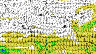
The Deep Depression is also generating strong squally winds over coastal and inland areas.
|
Region |
Wind Forecast |
|
Northwest Bay of Bengal & Odisha-West Bengal coast |
45–55 kmph, gusting to 65 kmph during next 12 hours |
|
North Interior Odisha, adjoining West Bengal & Jharkhand |
45–55 kmph, gusting to 65 kmph during next 24 hours |
|
Westcentral Bay & North Andhra Pradesh coast |
40–50 kmph during next 12 hours |
The IMD said wind speeds are expected to reduce gradually as the system moves further inland.
Rough Sea Conditions; Fishermen Advised Not to Venture Out
Sea conditions are expected to remain very rough to rough over the northwest Bay of Bengal and along the coasts of Odisha, West Bengal and north Andhra Pradesh during the next 12 hours. Rough conditions are likely to persist until the morning of July 29, after which gradual improvement is expected.
The IMD has advised fishermen not to venture into the northwest Bay of Bengal and adjoining Odisha, West Bengal and north Andhra Pradesh coasts till the morning of July 29.
Flash Flood Risk in Three States
The IMD has also issued a low to moderate flash flood risk for the next 24 hours across several districts of Odisha, Jharkhand and Chhattisgarh.
Among the districts on alert are Balasore, Bhadrak, Kendrapara, Mayurbhanj, Keonjhargarh, Angul and Dhenkanal in Odisha; Ranchi, East Singhbhum, West Singhbhum, Gumla and Simdega in Jharkhand; and Raigarh, Surguja, Korba, Jashpur, Korea and Mahasamund in Chhattisgarh.
The weather agency warned that saturated soils could lead to surface runoff, inundation of low-lying areas and localized flash flooding.
Possible Impact
Authorities have been cautioned about multiple weather-related hazards, including:
|
Expected Impact |
Details |
|
Agriculture |
Damage to standing crops, plantations and horticulture |
|
Trees |
Uprooting of small trees and breaking of branches |
|
Housing |
Minor damage to kutcha houses and vulnerable structures |
|
Transport |
Disruptions to road and rail traffic due to heavy rain |
|
Flooding |
Waterlogging, inundation and localized landslides |
|
Marine Operations |
Small boats, trawlers and fishing vessels at risk |
|
Aviation |
Helicopter operations may be affected |
|
Visibility |
Reduced visibility during intense rainfall |
Public Advisory
The IMD has urged residents in affected areas to closely monitor weather updates, avoid taking shelter under trees during thunderstorms, unplug electrical appliances during lightning, stay away from water bodies, and follow instructions issued by local authorities.
Tourism, recreational activities, offshore operations and helicopter services may also be regulated depending on local weather conditions.