Depression over Bay of Bengal intensifies, Met issues warning for heavy rainfall in Tamilnadu
Depression over southwest Bay of Bengal & adjoining Equatorial Indian Ocean is likely to intensify into a Deep Depression during next 24 hours
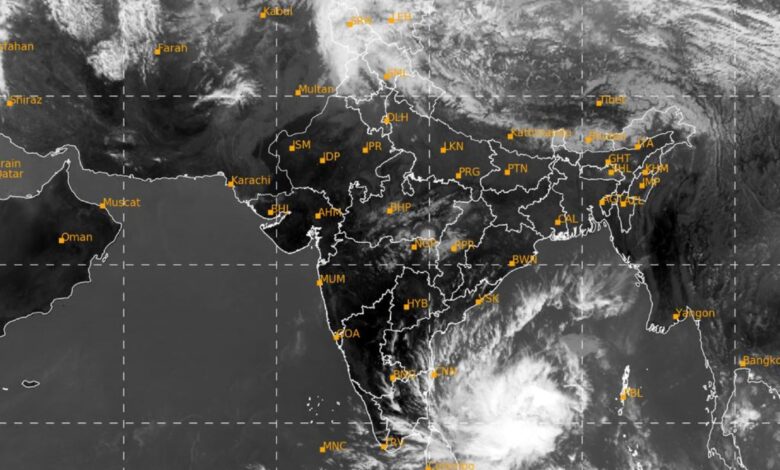
Depression over southwest Bay of Bengal & adjoining Equatorial Indian Ocean is likely to intensify into a Deep Depression during next 24 hours. It is likely to move northwestwards along & off east coast of Sri Lanka towards north Tamil Nadu Coast during next 48 hours.
Wet spell over Western Himalayan Region & adjoining plains on today and another fresh wet spell during 06th to 08th March, 2022 with possibility of isolated heavy falls over Jammu & Kashmir on 06th March, 2022
As per IMD…Low Pressure Area over Central parts of South Bay of Bengal & adjoining Equatorial Indian Ocean has concentrated into a depression over southwest Bay of Bengal & adjoining Equatorial Indian Ocean. It lies over about 420 km south-southeast of Trincomalee (Sri Lanka), 760 km south-southeast of Nagappattinam (Tamil Nadu), 820 km southsoutheast of Puducherry (Tamil Nadu) and about 900 km south-southeast of Chennai (Tamil Nadu). It is likely to intensify further into a Deep Depression during next 24 hours. It is likely to move northwestwards along and off east coast of Sri Lanka towards north Tamil Nadu Coast during next 48 hours. Under its influence:
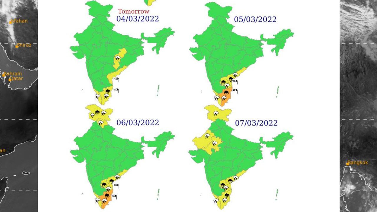
Rainfall forecast & Warnings:
Light to moderate rainfall/thunder shower at a few places likely over coastal Tamil Nadu, Puducherry & Karaikal on 03rd March, 2022.
Light to moderate rainfall/thunder shower at many places with isolated heavy rainfall likely over coastal Tamil Nadu, Puducherry & Karaikal; light to moderate rainfall/thunder shower at a few places likely over south coastal Andhra Pradesh and Rayalaseema on 04 th March, 2022.
Light to moderate rainfall/thunder shower at most places with heavy to very heavy rainfall at isolated places very likely over north coastal Tamil Nadu, Puducherry & Karaikal; light to moderate rainfall/thunder shower at many places with isolated heavy falls very likely over south coastal Andhra Pradesh and Rayalaseema on 05th & 06th March, 2022.
Light to moderate rainfall/thunder shower at most places with heavy to very heavy rainfall at isolated places very likely over north Tamil Nadu, Puducherry & Karaikal and isolated heavy falls very likely over south coastal Andhra Pradesh and Rayalaseema on 07 th March, 2022.
Wind warning:
Squally winds speed reaching 45-55 kmph gusting to 65 kmph are very likely to prevail over Southwest & adjoining Westcentral Bay of Bengal, Gulf of Mannar and along & off Tamil Nadu, Puducherry coasts. Squally winds speed reaching 40-50 kmph gusting to 60 kmph are very likely over Equatorial Indian Ocean on 03 rd March, 2022.
Squally winds speed would gradually increase becoming 50-60 kmph gusting to 70 kmph over Southwest & adjoining Westcentral Bay of Bengal, Gulf of Mannar and along & off north Tamil Nadu, Puducherry & South Andhra Pradesh coasts on 04 th & 05 th March, 2022.
Squally winds speed reaching 40-50 kmph gusting to 60 kmph are very likely to prevail over Westcentral & adjoining Southwest Bay of Bengal and along & off north Tamil Nadu, Puducherry and south Andhra Pradesh coasts on 06th March, 2022. Sea condition:
Sea condition will be rough to very rough over Southwest & adjoining westcentral Bay of Bengal, Gulf of Mannar and Comorin area and along & off Tamil Nadu, Puducherry & south Andhra Pradesh coasts during 3 rd – 6 th March. Sea condition will be rough to very rough over adjoining Equatorial Indian Ocean on 3rd March, 2022. Fishermen Warning:
Fishermen are advised not to venture into Southwest & adjoining Westcentral Bay of Bengal, adjoining Equatorial Indian Ocean, Gulf of Mannar, Comorin area and along & off Tamil Nadu, Puducherry and south Andhra Pradesh coasts till 6th March, 2022.
The Western Disturbance as a cyclonic circulation lies over north Pakistan & neighbourhood in lower & middle tropospheric levels and an induced cyclonic circulation lies over West Rajasthan & neighbourhood in lower tropospheric levels. Under their influence:
Fairly widespread to widespread light/moderate rainfall/snowfall with isolated thunderstorm/lightning very likely over Jammu-Kashmir-Ladakh-Gilgit-BaltistanMuzaffarabad & Himachal Pradesh and Uttarakhand during next 24 hours.
Isolated light rainfall very likely over Punjab, Haryana-Chandigarh-Delhi and West Uttar Pradesh during next 24 hours.
Strong surface Winds (speed 25-35 kmph) very likely to prevail over HaryanaChandigarh-Delhi & Rajasthan on 04th March and over most parts of plains of northwest India on 05th March, 2022.