
Rainfall to Continue Across Central, East, Northeast and Southern India; Heavy Rain Expected in Several States From August 22

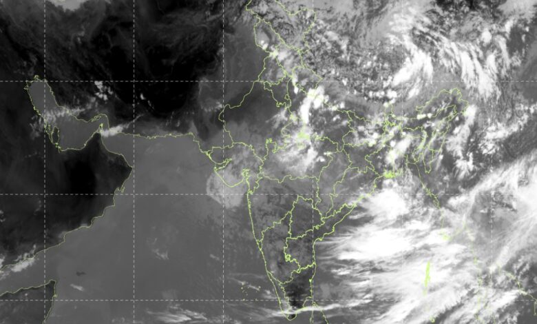
The India Meteorological Department (IMD) has forecast continued rainfall activity across several parts of India from August 22 onwards, with heavy to very heavy rainfall expected in parts of East and Central India, Odisha, Bihar, the Northeast and the southern peninsula. The forecast is based on multiple weather systems currently influencing the monsoon pattern across the country.
The IMD said a Low-Pressure Area over northeast Madhya Pradesh and adjoining areas was persisting on August 21 after weakening from a well-marked low-pressure area. The monsoon trough’s western end is also positioned north of its normal location, while several upper-air cyclonic circulations are influencing weather over Haryana, Gangetic West Bengal, Jharkhand, Madhya Pradesh, the Bay of Bengal and adjoining coastal areas.
Forecast from August 22 onwards
| Region | Forecast from August 22 onwards | Heavy Rainfall Outlook |
|---|---|---|
| Northwest India | Rainfall over Delhi, Haryana and East Uttar Pradesh; Uttarakhand remains active | Heavy rain over East UP, Haryana, Delhi, Himachal Pradesh and Punjab; Uttarakhand through Aug 27 |
| Central India | Widespread rain over Madhya Pradesh, Chhattisgarh and later Vidarbha | Heavy rain in West MP through Aug 25, East MP Aug 23-26 and Chhattisgarh through Aug 27 |
| East India | Widespread rain over Jharkhand, Odisha, Bihar and West Bengal | Heavy rain in Bihar Aug 22-25, Jharkhand Aug 23 and Odisha Aug 22-23; very heavy rain in Odisha Aug 24-27 |
| Northeast India | Rainfall continues across Arunachal Pradesh, Assam, Meghalaya and NMMT states | Heavy rain in Assam-Meghalaya through Aug 27 and Arunachal Pradesh Aug 23-27 |
| West India | Rain mainly over Konkan-Goa, with scattered activity in Gujarat and adjoining regions | Widespread rain over Konkan-Goa; scattered rainfall over Gujarat, Marathwada and Saurashtra-Kutch |
| South Peninsular India | Rainfall continues over coastal and southern areas | Heavy rain over Kerala and Karnataka Aug 23-25; Tamil Nadu Aug 24-25 |
The IMD forecast indicates that Central and East India will remain among the main areas of concern. West Madhya Pradesh is likely to receive fairly widespread to widespread rainfall through August 25, while East Madhya Pradesh is expected to remain active through August 26. Chhattisgarh is forecast to receive widespread rainfall through August 27. Heavy rainfall is expected over East Madhya Pradesh from August 23 to 26, while isolated very heavy rainfall is forecast over the region on August 21 and 22.
In East India, widespread rainfall is expected over Jharkhand and Odisha from August 22 to 27, while Bihar is likely to experience widespread rainfall from August 22 to 24. Sub-Himalayan West Bengal and Sikkim are expected to remain wet through August 26-27. Of particular significance is Odisha, where isolated very heavy rainfall is forecast from August 24 to 27. Heavy rainfall is also likely over Odisha on August 22-23 and over Bihar between August 22 and 25.
Northwest India
Rainfall activity is expected to continue over the western Himalayan region. Uttarakhand is forecast to receive fairly widespread to widespread rainfall through August 27, accompanied by isolated heavy rainfall and thunderstorms. East Uttar Pradesh is likely to see widespread rainfall between August 22 and 24.
The IMD has also forecast heavy rainfall over East Uttar Pradesh, Haryana, Chandigarh and Delhi, Himachal Pradesh and Punjab around August 21-22, while isolated heavy rainfall is expected over Jammu and Kashmir and Ladakh on August 22.
Northeast to remain wet
The Northeast is also expected to remain active from August 22 onwards. Arunachal Pradesh is likely to receive heavy rainfall during August 23-27, while Assam and Meghalaya could experience heavy rainfall through August 27. Nagaland, Manipur, Mizoram and Tripura are forecast to receive heavy rainfall during August 21-24.
The IMD has identified a low to moderate flash-flood risk in some watersheds and adjoining areas of Assam, Meghalaya, Manipur, Mizoram and Nagaland during the 24 hours ending 1130 IST on August 22. Saturated soils and low-lying areas could experience surface runoff or inundation where additional rainfall occurs.
Southern Peninsula: subdued but persistent rainfall
Although the IMD has described rainfall activity over Peninsular India as broadly subdued during the coming week, several southern and coastal areas will continue to receive rainfall. Fairly widespread to widespread rainfall is expected over Coastal Karnataka, Kerala and Mahe and Lakshadweep through August 27. Scattered rainfall is forecast over Tamil Nadu, Telangana, Coastal Andhra Pradesh, Rayalaseema and parts of Karnataka.
Heavy rainfall is expected over Kerala and Mahe from August 23-25, Coastal Karnataka and North Interior Karnataka on August 23-24, and Tamil Nadu, Puducherry and Karaikal on August 24-25.
Thunderstorms and gusty winds will also remain a concern in parts of southern India. Tamil Nadu and adjoining areas may experience gusty winds reaching 40-50 kmph, with gusts up to 60 kmph, through August 23. Similar activity is forecast over North Interior Karnataka through August 24 and parts of Andhra Pradesh and Rayalaseema through August 25.
Coastal and marine conditions
The IMD has issued a warning for fishermen as rough weather is expected over parts of both the Arabian Sea and Bay of Bengal. Along and off Kerala, Lakshadweep and the Comorin area, adverse marine conditions are forecast from August 23 to 26. Parts of the westcentral Bay of Bengal and areas along and off the North Andhra Pradesh coast are also expected to experience unfavourable conditions from August 22 to 26.
Delhi-NCR forecast
Delhi-NCR is likely to experience generally cloudy conditions on August 22, with one or two spells of very light to light rain at many places and moderate rain at isolated locations from early morning to noon. Another spell of light rain is possible towards night. Temperatures are expected to remain around 32-34°C, with minimum temperatures between 24°C and 26°C.
On August 23, light rain is expected at a few places from morning to afternoon, with temperatures remaining around 32-34°C. On August 24, isolated light rain is possible during the morning, while temperatures are forecast to range between 33°C and 35°C.
Rainfall-related risks
The IMD has warned that heavy rainfall could lead to waterlogging, localised flooding, inundation, landslides, mudslides and reduced visibility, particularly in vulnerable urban and hilly areas. Strong winds accompanying thunderstorms may damage trees, crops and vulnerable structures and could affect road and rail traffic.
The weather agency has advised people to closely monitor weather updates, avoid taking shelter under trees during lightning and regulate tourism and recreational activities in areas facing severe weather. Farmers in affected regions have been advised to maintain drainage and promptly remove excess water from agricultural fields.
With rainfall expected to remain active across Central, East, Northeast and parts of Northwest and South India from August 22 onwards, authorities and residents in vulnerable areas are likely to need continued monitoring of district-level warnings. The IMD has stressed that forecast accuracy decreases as the lead period increases, making updated warnings particularly important during periods of heavy rainfall.