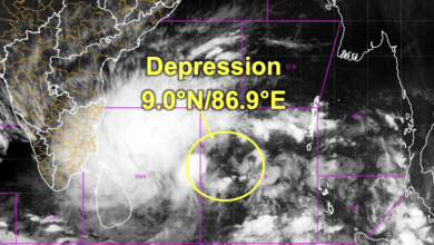
Cyclone Akwan: Deep Depression Over Bay of Bengal Likely to Intensify into Very Severe Cyclonic Storm
IMD forecasts cyclone formation over the Bay of Bengal on November 16, followed by intensification into a Severe Cyclonic Storm on November 17 and a Very Severe Cyclonic Storm on November 19. North Coastal Andhra Pradesh may receive extremely heavy rainfall, while Odisha, Tamil Nadu and neighbouring states brace for heavy rain and strong winds.

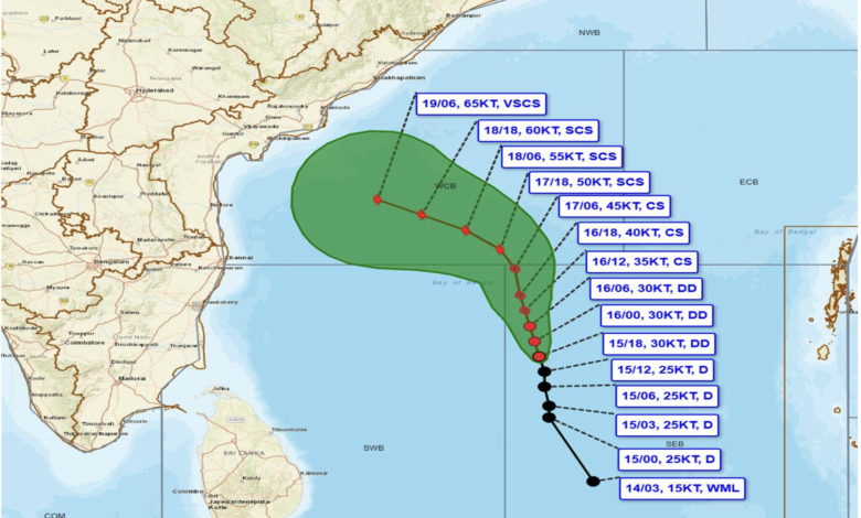
The weather system developing over the southeast and adjoining southwest Bay of Bengal has intensified into a Deep Depression and is likely to develop into a powerful cyclonic storm, potentially reaching the category of a Very Severe Cyclonic Storm by November 19, 2026. The India Meteorological Department (IMD), in its National Bulletin No. 5 issued at 2:30 am on November 16, has warned of worsening weather conditions over the Bay of Bengal and along the eastern coastline, particularly Andhra Pradesh and Odisha.
The system is expected to intensify into a Cyclonic Storm over the central parts of the south and adjoining west-central Bay of Bengal by the evening of November 16. It is subsequently likely to strengthen into a Severe Cyclonic Storm over the west-central Bay of Bengal by the evening of November 17.
According to the IMD forecast, the system may intensify further while moving northwestwards towards the Andhra Pradesh coast over the following two days. By November 19, it is forecast to become a Very Severe Cyclonic Storm, with maximum sustained wind speeds of 120–130 kmph and gusts reaching 145 kmph.
The developing system has been named Cyclone Akwan, a name contributed by Iran under the regional naming system for tropical cyclones.
The IMD has issued a pre-cyclone watch for the Andhra Pradesh and adjoining south Odisha coasts under its Yellow Message category. Authorities, fishermen, shipping operators and coastal communities have been advised to closely monitor subsequent weather bulletins and take precautionary measures.
Deep Depression Located 760 km from Chennai
According to the latest observations available in the IMD bulletin, the depression moved north-northwestwards at a speed of approximately 8 kmph during the six hours preceding its intensification into a Deep Depression.
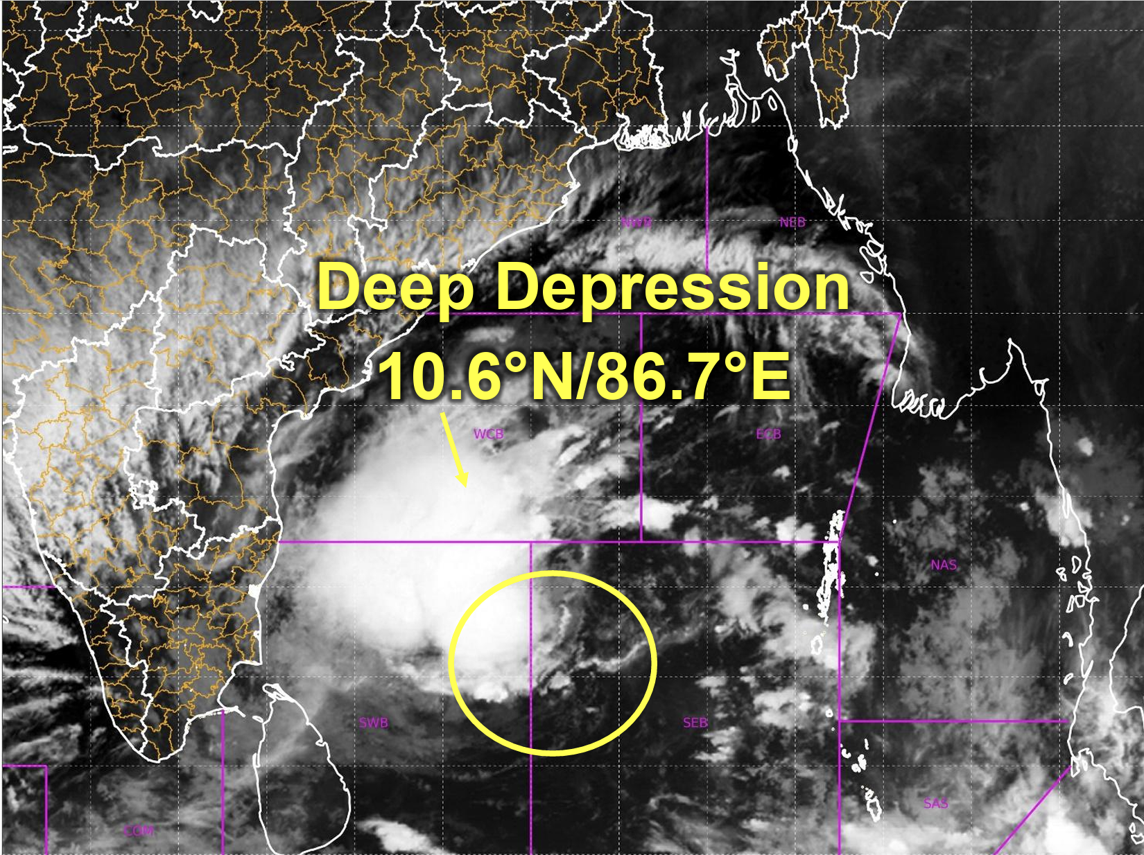
At 11:30 pm IST on November 15, the system was centred over the southeast and adjoining southwest Bay of Bengal, near latitude 10.6°N and longitude 86.7°E.
Its estimated distance from important coastal and island locations was:
| Location | Distance and direction |
|---|---|
| Trincomalee, Sri Lanka | 640 km east-northeast |
| Sri Vijaya Puram, Andaman and Nicobar Islands | 670 km west |
| Chennai, Tamil Nadu | 760 km east-southeast |
| Visakhapatnam, Andhra Pradesh | 870 km south-southeast |
| Gopalpur, Odisha | 980 km south-southeast |
The system is expected to maintain its north-northwestward movement before gradually turning northwestwards towards the Andhra Pradesh coastline.
The IMD has indicated that the system’s intensity will increase steadily over the next three days, accompanied by strengthening winds, deteriorating sea conditions and widespread rainfall over several eastern and southern states.
Cyclone Akwan: Expected Track and Intensity
The IMD’s forecast indicates a gradual strengthening of the system from a Deep Depression into a Very Severe Cyclonic Storm between November 16 and November 19.
The following table provides the expected position and wind intensity based on the latest forecast issued on November 16.
| Date and Time (IST) | Maximum Sustained Wind Speed | Expected Category |
|---|---|---|
| November 16, 5:30 am | 55–65 kmph, gusting to 75 kmph | Deep Depression |
| November 16, 11:30 am | 55–65 kmph, gusting to 75 kmph | Deep Depression |
| November 16, 5:30 pm | 60–70 kmph, gusting to 80 kmph | Cyclonic Storm |
| November 16, 11:30 pm | 70–80 kmph, gusting to 90 kmph | Cyclonic Storm |
| November 17, 11:30 am | 80–90 kmph, gusting to 100 kmph | Cyclonic Storm |
| November 17, 11:30 pm | 90–100 kmph, gusting to 110 kmph | Severe Cyclonic Storm |
| November 18, 11:30 am | 100–110 kmph, gusting to 120 kmph | Severe Cyclonic Storm |
| November 18, 11:30 pm | 110–120 kmph, gusting to 130 kmph | Severe Cyclonic Storm |
| November 19, 11:30 am | 120–130 kmph, gusting to 145 kmph | Very Severe Cyclonic Storm |
The forecast suggests that the system could gain considerable strength while travelling over the Bay of Bengal. The period between November 17 and November 19 will be particularly important, as the storm is expected to strengthen significantly and approach the eastern coastline.
The forecast intensity and track remain subject to revision in subsequent IMD bulletins.
Andhra Pradesh Faces Extremely Heavy Rainfall Threat
Andhra Pradesh is expected to experience some of the most significant weather impacts associated with the developing cyclone.
The IMD has forecast light to moderate rainfall at many places across coastal Andhra Pradesh, accompanied by heavy rainfall at isolated locations on November 18.
Conditions are expected to deteriorate further on November 19 and 20, when light to moderate rainfall is likely at most places, with heavy to very heavy rainfall at a few locations.
The most significant warning concerns north coastal Andhra Pradesh, where isolated places could receive extremely heavy rainfall of 21 cm or more.
The IMD has also warned of heavy rainfall over Rayalaseema on November 19 and 20.
Strong winds are another major concern. Along and off the Andhra Pradesh and Yanam coasts, squally weather with wind speeds of 40–50 kmph, gusting to 60 kmph, is expected until November 17.
Wind speeds are likely to increase gradually, reaching 60–70 kmph with gusts of up to 80 kmph until the morning of November 19.
The situation could become considerably more severe from the evening of November 19 until the morning of November 20, when winds may reach 120–130 kmph, with gusts up to 145 kmph.
Sea conditions are also expected to deteriorate from rough to very rough initially to high and very high conditions. Phenomenal sea conditions are forecast along and off the Andhra Pradesh and Yanam coasts from the evening of November 19 until the morning of November 20.
Odisha Likely to Receive Heavy to Very Heavy Rainfall
Odisha is also expected to experience adverse weather conditions as the system moves northwestwards.
The IMD has forecast light to moderate rainfall at many places, with heavy rainfall at isolated locations on November 18.
Rainfall activity is expected to intensify between November 19 and November 21, with heavy to very heavy rainfall likely at isolated locations across the state.
The coastal districts could experience strong winds and rough sea conditions as the cyclone approaches the eastern coastline.
Along and off the Odisha coast, squally winds reaching 40–50 kmph, gusting to 60 kmph, are likely on November 18.
Wind speeds may increase to 50–60 kmph, with gusts reaching 70 kmph, from November 19 until the morning of November 20.
Sea conditions are expected to remain rough to very rough from November 18 until the morning of November 20.
The IMD has advised coastal authorities and fishing communities to closely monitor the evolving situation.
Tamil Nadu and Puducherry to Experience Heavy Rainfall
Although the developing system is expected to move towards the Andhra Pradesh coast, Tamil Nadu and Puducherry are also likely to experience rainfall associated with the system.
The IMD has forecast light to moderate rainfall at many places over north Tamil Nadu, Puducherry and Karaikal, with heavy rainfall at isolated locations on November 17 and November 20.
Heavy to very heavy rainfall is likely at isolated locations on November 18 and 19.
Along and off the north Tamil Nadu and Puducherry coasts, squally weather with wind speeds of 40–50 kmph, gusting to 60 kmph, is likely to continue until November 18.
Rough to very rough sea conditions are also expected along these coastal stretches during this period.
The Andaman and Nicobar Islands are likely to receive light to moderate rainfall at most places between November 15 and November 17.
Rainfall Warning for Telangana, Chhattisgarh, West Bengal and Jharkhand
The impact of the developing weather system is likely to extend beyond the immediate coastal regions.
The IMD has issued rainfall warnings for several inland states as the system progresses towards the northwest.
| State/Region | Forecast Date | Expected Weather |
|---|---|---|
| Telangana | November 20 | Heavy rainfall at isolated places over eastern Telangana |
| Chhattisgarh | November 20–21 | Heavy rainfall at isolated places in south and north Chhattisgarh, respectively |
| Gangetic West Bengal | November 19–20 | Heavy rainfall at isolated places |
| Jharkhand | November 20–21 | Heavy rainfall at isolated places |
| Rayalaseema | November 19–20 | Heavy rainfall at isolated places |
These forecasts indicate that the weather system could influence a wide geographical area, bringing rainfall to several states beyond the immediate cyclone-prone coastal belt.
Strong Winds and Deteriorating Sea Conditions Over Bay of Bengal
The IMD has issued extensive marine warnings covering different parts of the Bay of Bengal.
Wind speeds are expected to increase progressively as the system intensifies.
Over the southeast Bay of Bengal, squally winds reaching 50–60 kmph, gusting to 70 kmph, are prevailing. These may strengthen to 55–65 kmph, gusting to 75 kmph, during the morning of November 16.
Gale-force winds of 60–70 kmph, gusting to 80 kmph, are expected from the afternoon of November 16. Wind speeds could reach 80–90 kmph, gusting to 100 kmph, over the subsequent 24 hours.
The southwest Bay of Bengal is also expected to experience strengthening winds. Gale-force winds reaching 65–75 kmph, gusting to 85 kmph, are forecast from the afternoon of November 16. These could increase to 85–95 kmph, gusting to 105 kmph, from November 17 and 100–110 kmph, gusting to 120 kmph, from November 18.
The west-central Bay of Bengal could experience particularly severe conditions. Winds may reach 110–120 kmph, gusting to 130 kmph, from the morning of November 18. By November 19, wind speeds could increase further to 120–130 kmph, with gusts reaching 145 kmph.
Sea conditions are also expected to deteriorate significantly.
The west-central Bay of Bengal could experience high to very high sea conditions from November 17 and 18, becoming very high to phenomenal from November 19.
The southwest Bay of Bengal is likely to experience high to very high sea conditions between November 17 and 19.
Fishermen Advised Not to Venture into Sea
In view of the intensifying weather system, the IMD has issued warnings advising fishermen not to venture into several parts of the Bay of Bengal and the Andaman Sea.
The restrictions cover the following areas:
-
Andaman Sea and Andaman and Nicobar Islands: Until November 17.
-
Southeast Bay of Bengal: Until November 17.
-
Southwest Bay of Bengal: November 16–19.
-
Central Bay of Bengal: November 16–20.
-
Northwest Bay of Bengal: November 19–20.
Fisheries departments and fishing harbour authorities have been advised to alert fishing communities and closely monitor subsequent marine weather warnings.
Shipping companies, port authorities and offshore operators have also been advised to review their operational preparedness.
Maritime authorities have been asked to strengthen communication systems, vessel tracking and search-and-rescue preparedness, particularly for vessels operating in areas likely to be affected by the cyclone.
Restrictions on fishing, shipping, port operations and marine tourism activities will be guided by subsequent IMD advisories.
Possible Impact: Flooding, Traffic Disruptions and Crop Damage
The IMD has highlighted the possibility of localised flooding and waterlogging, particularly in areas expected to receive heavy to extremely heavy rainfall.
Andhra Pradesh is likely to experience significant rainfall impacts between November 18 and 20, while Odisha could face heavy rainfall between November 18 and 21.
The possible impacts include:
-
Localised flooding of roads and waterlogging in low-lying areas.
-
Closure of underpasses, particularly in urban locations.
-
Reduced visibility due to intense rainfall.
-
Disruption of traffic in major cities and increased travel time.
-
Minor damage to kutcha roads.
-
Inundation-related damage to horticulture and standing crops in affected areas.
Urban authorities have been advised to remain alert to waterlogging and drainage-related problems, while agricultural communities should monitor local advisories.
Authorities Asked to Maintain Preparedness
The IMD has advised state authorities, disaster management agencies and maritime organisations to remain prepared as the system intensifies.
Fishing communities have been urged to follow area-specific warnings rather than relying on general weather updates. Port and shipping operators have been advised to assess operational risks and consider restrictions on weather-sensitive activities.
The cyclone’s projected movement towards the Andhra Pradesh coast makes the next 72 hours particularly important for coastal preparedness.
The IMD is continuing to monitor the system and will issue updated forecasts regarding its movement, intensity and potential landfall.