
Depression Over Bay of Bengal Likely to Intensify into Severe Cyclonic Storm Akvan by November 17
Cyclone to be named Akvan, with Iran contributing the name; system is moving north-northwestwards and may intensify further over the westcentral Bay of Bengal

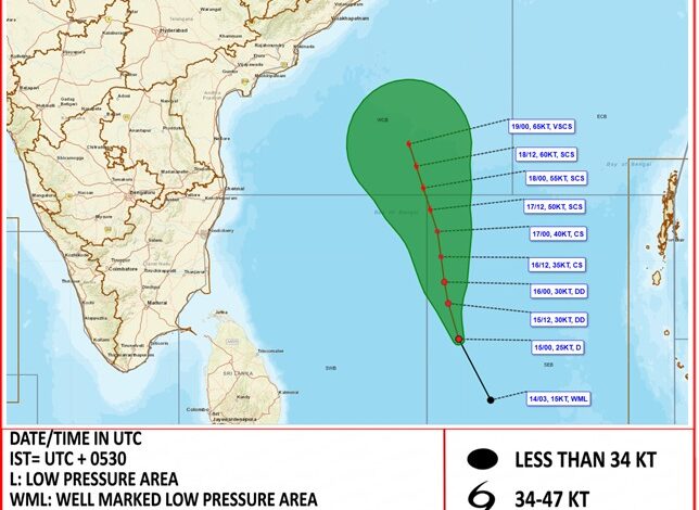
The weather system, which developed from a Well Marked Low Pressure Area over the Southeast Bay of Bengal, has been moving north-northwestwards and gaining strength. According to the IMD’s latest bulletin issued at 0530 hours IST on November 15, 2026, the system is centred over the Southeast and adjoining Southwest Bay of Bengal.
The depression was located near latitude 9.0°N and longitude 86.9°E, approximately 700 km west-southwest of Port Blair (Andaman Islands), 860 km east-southeast of Chennai (Tamil Nadu), 1,040 km south-southeast of Visakhapatnam (Andhra Pradesh) and 1,160 km south-southeast of Gopalpur (Odisha).
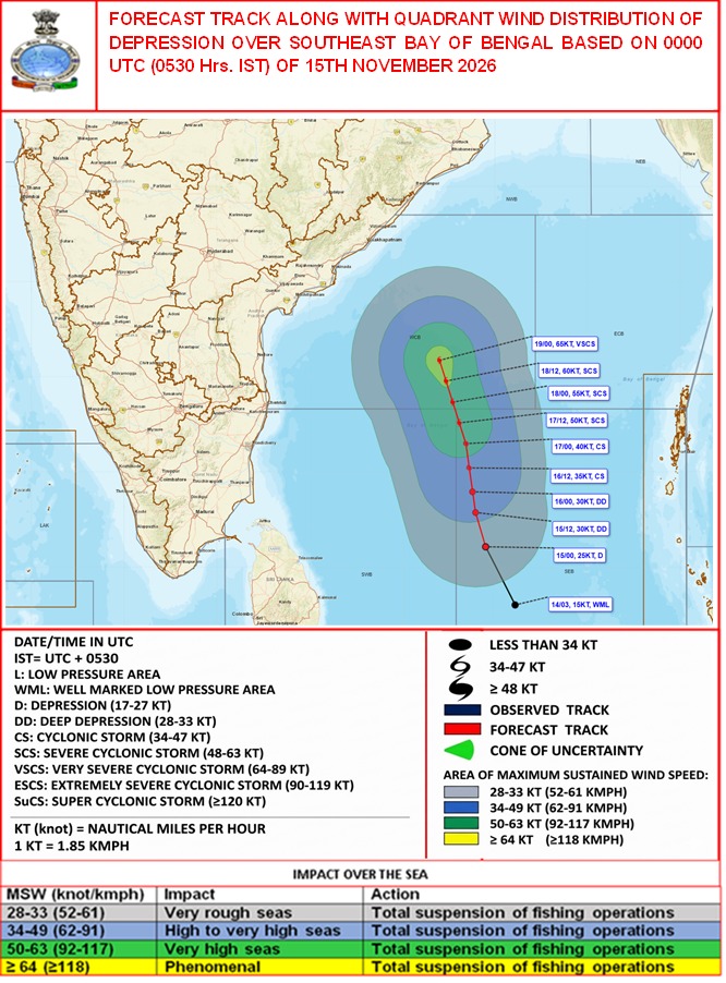
Depression Likely to Become Cyclonic Storm on November 16
According to the IMD, the depression is very likely to continue moving north-northwestwards over the Bay of Bengal and intensify further during the next few days.
The system is expected to strengthen into a Cyclonic Storm over the central parts of the South and adjoining Westcentral Bay of Bengal on November 16, 2026. Subsequently, it is likely to intensify into a Severe Cyclonic Storm over the Westcentral Bay of Bengal on November 17.
The forecast track issued by the IMD indicates a gradual increase in wind speed as the system progresses north-northwestwards.
The forecast suggests that the system could initially strengthen into a depression with wind speeds of around 25 knots on November 15. It may subsequently intensify into a Deep Depression, with wind speeds reaching approximately 30 knots.
By November 16, the system is expected to develop into a Cyclonic Storm, with wind speeds potentially reaching 36 knots. Further intensification is forecast on November 17, when wind speeds could increase to around 50 knots, bringing the system into the Severe Cyclonic Storm category.
The forecast track also indicates the possibility of further strengthening over the following days, with wind speeds potentially reaching 60 knots on November 18 and 65 knots by November 19, when the system could become a Very Severe Cyclonic Storm.
The IMD has also released a forecast cone showing the projected movement of the depression and the associated cone of uncertainty. The cone represents the probable area within which the system’s centre may move, rather than indicating the exact path it will follow.
Cyclone to Be Named Akvan
Once the depression intensifies into a Cyclonic Storm and achieves the prescribed minimum wind speed of 34 knots (approximately 62 kmph), it will be named Akvan.
The name Akvan has been contributed by Iran under the regional tropical cyclone naming system followed by the World Meteorological Organization (WMO) and the United Nations Economic and Social Commission for Asia and the Pacific (UNESCAP).
The India Meteorological Department’s Regional Specialized Meteorological Centre (RSMC), New Delhi, is responsible for monitoring and issuing advisories for tropical cyclones developing over the North Indian Ocean, including the Bay of Bengal and the Arabian Sea.
Cyclone names are assigned sequentially from the pre-approved list of names contributed by countries in the region. A weather system receives a cyclone name after developing into a Cyclonic Storm with maximum sustained winds reaching at least 34 knots.
IMD Monitoring System’s Further Intensification
The depression’s expected intensification over the coming days makes its movement and development important for weather monitoring across the Bay of Bengal region.
The IMD is tracking the system’s position, movement and intensity through satellite observations, meteorological models and other monitoring systems. The forecast track and cone of uncertainty will be updated as fresh observations become available.
The system’s further development into Cyclonic Storm Akvan and its subsequent intensification will remain under close observation by the meteorological department.