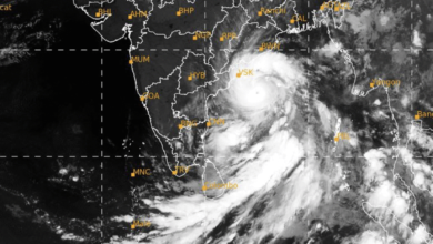
Cyclone Arnab to Make Landfall in Andhra Pradesh on October 28; IMD Warns of Winds up to 150 kmph, Extreme Rainfall and Storm Surge
Red alert issued for Andhra Pradesh and adjoining south Odisha coast as Very Severe Cyclonic Storm Arnab approaches the coastline. Extremely heavy rainfall, coastal inundation, flooding and major disruptions to road and rail networks are expected across several states.

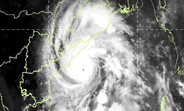
Very Severe Cyclonic Storm Arnab is advancing towards the Andhra Pradesh coast over the west-central Bay of Bengal and is expected to make landfall between Bapatla and Visakhapatnam, close to Yanam, by the forenoon of October 28, the India Meteorological Department (IMD) said in its National Bulletin No. 17 issued at 12:40 pm on Tuesday.
The cyclone is expected to cross the coast with maximum sustained wind speeds of 125–135 kmph, gusting up to 150 kmph. The IMD has issued a red message for Andhra Pradesh and the adjoining south Odisha coast, warning of destructive winds, extremely heavy rainfall, storm surge and widespread disruption to transport, power supply, agriculture and coastal infrastructure.
As of 8:30 am on October 27, the storm was centred near latitude 16.0°N and longitude 84.3°E, approximately 220 km south-southeast of Visakhapatnam, 240 km east-southeast of Kakinada and 340 km east-southeast of Machilipatnam. It was also located around 370 km south of Gopalpur in Odisha.
The cyclone moved west-northwestwards at approximately 20 kmph during the preceding six hours. According to the IMD, it was likely to continue moving in a west-northwestward direction until the evening of October 27 before turning northwestwards towards the Andhra Pradesh and Yanam coastline.
The system is under continuous surveillance by the Doppler Weather Radar at Visakhapatnam.
Cyclone to Bring Winds of Up to 180 kmph Over the Sea
The IMD has warned that Arnab could maintain extremely dangerous wind speeds over the sea before gradually weakening after landfall.
At 8:30 am on October 27, the cyclone was associated with sustained winds of 140–150 kmph, gusting up to 165 kmph. The bulletin projected that wind speeds could increase to 150–160 kmph, with gusts reaching 180 kmph, by noon and continue at these levels until the evening.
The system is forecast to weaken gradually thereafter. By midnight on October 27, sustained winds could decrease to 135–145 kmph, with gusts up to 160 kmph. By the early morning of October 28, winds are expected to reach 125–135 kmph, gusting up to 150 kmph, around the anticipated landfall period.
After crossing the coast, Arnab is expected to weaken into a cyclonic storm by the evening of October 28, with sustained winds of 90–100 kmph and gusts up to 110 kmph.
The system is then forecast to weaken into a deep depression by the morning of October 29, with winds of 50–60 kmph, before further deteriorating into a depression later that day.
By October 30, it is likely to weaken into a well-marked low-pressure area.
Although the cyclone is expected to weaken after landfall, its associated rainfall and the resulting risks of flooding could continue across inland regions for several days.
Extremely Heavy Rainfall Forecast in Andhra Pradesh and Odisha
Heavy to extremely heavy rainfall is among the principal threats associated with Cyclone Arnab. The IMD has warned that intense precipitation could trigger flash floods, river flooding, urban inundation, waterlogging and damage to standing crops.
Andhra Pradesh
Coastal Andhra Pradesh is expected to experience widespread light to moderate rainfall, with heavy to very heavy rainfall of 7–20 cm at a few places and extremely heavy rainfall of 21 cm or more at isolated locations on October 27 and 28.
The warning covers the period immediately preceding and following landfall, when strong winds and intense rain could combine to create dangerous conditions in coastal districts.
On October 29, isolated heavy rainfall is expected over north coastal Andhra Pradesh.
The IMD has warned of extensive damage to thatched and kutcha houses, possible damage to some pucca houses, uprooting of trees, disruption of electricity and communication networks, and damage to agricultural plantations.
Odisha
South Odisha is likely to receive heavy to very heavy rainfall at a few places and extremely heavy rainfall at isolated locations on October 27.
On October 28, heavy to very heavy rainfall is expected at several places in south Odisha, with extremely heavy rainfall possible at isolated locations. North Odisha is also likely to experience heavy to very heavy rainfall at isolated places.
Interior Odisha may receive heavy rainfall on October 29.
The combination of heavy precipitation and strong winds could cause waterlogging, localised flooding, crop damage and disruption to road connectivity, particularly in vulnerable coastal and hilly areas.
Telangana and Chhattisgarh
Eastern Telangana is likely to experience heavy to very heavy rainfall at isolated places on October 28.
In south Chhattisgarh, light to moderate rainfall with isolated heavy spells is forecast on October 27. The situation could intensify on October 28, when heavy to very heavy rainfall at several places and extremely heavy rainfall at isolated locations are likely.
North Chhattisgarh is expected to receive heavy to very heavy rainfall at a few places on October 29.
The IMD has also warned of squally winds in parts of south Chhattisgarh and northeastern Telangana, potentially affecting trees, power lines and local transport.
Jharkhand, Bihar and West Bengal
Jharkhand is likely to receive light to moderate rainfall at many places, with isolated heavy rainfall on October 28. Heavy to very heavy rainfall is expected at isolated locations on October 29.
Bihar may experience heavy to very heavy rainfall at isolated places on October 29 and 30.
Coastal districts of Gangetic West Bengal are likely to receive isolated heavy rainfall on October 28 and 29. Sub-Himalayan West Bengal and Sikkim could experience isolated heavy rainfall on October 29 and 30.
Maharashtra, Madhya Pradesh and Uttar Pradesh
Eastern Vidarbha is likely to receive heavy to very heavy rainfall at isolated places on October 28, followed by isolated heavy rainfall on October 29.
East Madhya Pradesh is expected to experience heavy rainfall at isolated places on October 28 and 30, with heavy to very heavy rainfall possible at isolated locations on October 29.
In eastern Uttar Pradesh, isolated heavy to very heavy rainfall is forecast on October 29. Northeastern Uttar Pradesh could receive heavy to very heavy rainfall on October 30, while isolated heavy rainfall is likely on October 31.
The rainfall forecast indicates that the impact of Arnab could extend well beyond the immediate landfall zone as the system weakens and moves inland.
Storm Surge of Up to Two Metres Could Inundate Coastal Areas
The IMD has issued a storm surge warning for low-lying areas of Andhra Pradesh, where seawater inundation is possible around the time of landfall.
A storm surge of approximately 1–2 metres above the astronomical tide is likely to inundate low-lying coastal areas. The maximum peak surge is expected near Kakinada and Yanam in the Union Territory of Puducherry.
The warning is particularly significant because storm surge, high tides and heavy rainfall can combine to worsen coastal flooding and obstruct the drainage of rainwater.
The IMD has cautioned that sea conditions over the west-central Bay of Bengal are likely to remain phenomenal until landfall. Along and off the Andhra Pradesh and Yanam coasts, sea conditions are forecast to deteriorate from rough to very rough on the morning of October 27, becoming high to very high by the afternoon and phenomenal from the night of October 27 until landfall.
The sea is expected to improve gradually after the cyclone crosses the coast, becoming very high to high by the evening of October 28 and very rough to rough by the morning of October 29.
South Odisha, the adjoining southwest Bay of Bengal, the north Tamil Nadu coast and the West Bengal coast are also likely to experience rough to very rough seas during the warning period.
Coastal Infrastructure, Power and Railways Face Disruption Risks
The IMD has highlighted the potential for extensive damage to infrastructure, particularly in coastal Andhra Pradesh on October 27 and 28.
Strong winds could uproot large trees, break branches and bend or uproot electricity and communication poles. Flying debris may pose a threat to people and buildings, while embankments and salt pans could sustain damage.
Thatched houses could suffer total destruction, and kutcha houses could sustain extensive damage. Some damage to stronger, permanent structures is also possible.
Agriculture is expected to be significantly affected. Standing crops, plantations and orchards could suffer widespread damage, with banana, papaya and drumstick trees particularly vulnerable. Green coconuts could fall, palm fronds could be torn and larger, bushy trees could be blown down.
Road and rail connectivity could also be affected by waterlogging, flooding and damage to infrastructure. The IMD has warned of major disruption to railway operations, overhead power lines and signalling systems in affected areas.
Flooding could damage kutcha roads, cause breaches in vulnerable stretches and block evacuation routes. Waterlogging in urban areas may slow traffic and increase travel times.
Authorities and commuters have been advised to monitor traffic advisories, check route conditions before travelling and avoid roads and other locations that are frequently affected by flooding.
The extent of transport disruption will depend on the cyclone’s actual track, rainfall intensity and the condition of local infrastructure.
Fishermen, Ports and Shipping Operations Put on Alert
The IMD has advised fishermen not to venture into the west-central Bay of Bengal from October 27 to 29. Fishing activities are also prohibited in the areas along and off the Andhra Pradesh and Odisha coasts during the same period.
Warnings also apply to the northwest Bay of Bengal and the West Bengal coast from October 27 to 29, as well as the southwest Bay of Bengal and the north Tamil Nadu–Puducherry coasts on October 27 and 28.
The IMD has warned that movement of boats and small vessels will be unsafe in the affected marine areas. Wave heights of 14 metres or more are indicated in the bulletin’s impact assessment for the phenomenal sea conditions associated with the cyclone.
Fisheries departments and fishing harbour authorities have been advised to alert fishing communities and monitor subsequent marine warnings. Shipping companies, port operators and offshore establishments have been urged to review their preparedness and follow weather-related restrictions.
Maritime authorities have also been advised to review vessel tracking, communications and search-and-rescue arrangements.
IMD Advises Evacuation and Precautionary Measures
Given the possibility of destructive winds, coastal inundation and widespread flooding, the IMD has recommended the evacuation of vulnerable coastal settlements and the relocation of people living in huts and other fragile structures to safer places.
People in affected areas have been advised to remain indoors and avoid staying in vulnerable buildings. Fishing operations should remain suspended, while offshore and onshore activities should be regulated according to the latest warnings.
Authorities have been advised to manage road and rail traffic carefully, issue timely travel advisories and take precautions in areas prone to waterlogging and flooding.
The bulletin also warns of secondary hazards, including riverine flooding, urban flooding, coastal inundation and possible landslides in hilly areas. Disruption to drinking water and sanitation services could create additional public health challenges.
In south Odisha, south Chhattisgarh and northeastern Telangana, squally winds of 40–50 kmph, gusting to 60 kmph, are expected to begin on the night of October 27. Winds could strengthen to 60–70 kmph, gusting to 80 kmph, during the early hours of October 28 in the most exposed districts.
These conditions are likely to continue until the night of October 28 before gradually weakening.
Cyclone’s Impact Expected to Continue Beyond Landfall
The IMD’s forecast indicates that Cyclone Arnab will weaken progressively after crossing the Andhra Pradesh coast, but its effects are expected to spread inland as the system moves northwestwards.
By the morning of October 29, the system is forecast to have weakened into a deep depression, with further weakening expected during the day. By October 30, it is likely to become a well-marked low-pressure area.
Heavy rainfall warnings extending into October 31 for parts of Uttar Pradesh, along with forecasts for Bihar, West Bengal, Chhattisgarh and Madhya Pradesh, indicate the possibility of continued weather-related disruption even after the coastal landfall.