Cyclone Alert for Andhra Pradesh and Odisha: IMD Forecasts Very Severe Cyclonic Storm by October 28

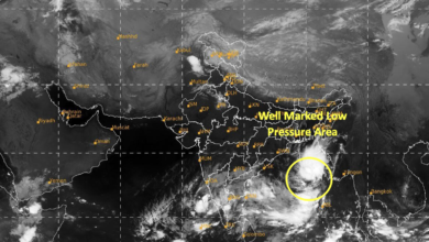
According to IMD’s National Bulletin No. 3, issued at 9 am on October 25, the depression was centred over the east-central and adjoining southeast Bay of Bengal at 5:30 am, near latitude 15.3°N and longitude 91.2°E. It was moving southeastwards at around 5 kmph during the preceding six hours.
The system was located approximately 440 km north-northwest of Sri Vijaya Puram in the Andaman Islands, 880 km east-southeast of Visakhapatnam, 980 km east-southeast of Kakinada, 1,080 km east of Machilipatnam and 1,150 km east of Bapatla.
Cyclone Likely to Intensify Over the Bay of Bengal
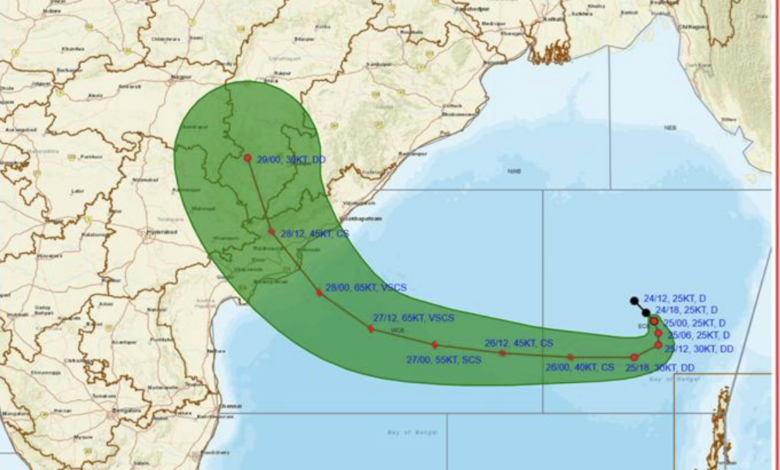
The IMD forecast indicates that the depression is likely to move nearly southwards initially before gradually recurving west-northwestwards. It is expected to intensify into a deep depression on October 25, followed by a cyclonic storm over the east-central and adjoining west-central Bay of Bengal by the morning of October 26.
The system is forecast to strengthen further into a severe cyclonic storm by the morning of October 27, with the possibility of reaching very severe cyclonic storm intensity later that day.
By the morning of October 28, the system is expected to approach the west-central Bay of Bengal near the Andhra Pradesh coast as a very severe cyclonic storm.
The IMD has forecast landfall along the Andhra Pradesh and Yanam coasts between Bapatla and Visakhapatnam by the forenoon of October 28. At landfall, the cyclone is expected to have maximum sustained wind speeds of 115–125 kmph, with gusts reaching 140 kmph.
After landfall, the system is forecast to weaken gradually. It could reduce to cyclonic storm intensity by the evening of October 28 and weaken further into a deep depression by the morning of October 29.
Extremely Heavy Rainfall Warning for Coastal States
The approaching cyclone is expected to trigger widespread rainfall across eastern and central India, with Andhra Pradesh and Odisha facing particularly significant weather risks.
| State or region | IMD rainfall forecast |
|---|---|
| Andaman Islands | Light to moderate rainfall at most places, with heavy rainfall at isolated locations, October 25–27 |
| Andhra Pradesh | Heavy to very heavy rainfall at a few places and extremely heavy rainfall at isolated locations on October 27–28; isolated heavy rainfall on October 29 |
| Odisha | Heavy to very heavy rainfall at isolated places on October 27; heavy to very heavy rainfall at a few places and extremely heavy rainfall at isolated locations on October 28 |
| Telangana | Heavy to very heavy rainfall at a few places and extremely heavy rainfall at isolated locations in eastern parts on October 28 |
| Chhattisgarh | Heavy to very heavy rainfall at isolated places in southern areas on October 28 and northern areas on October 29 |
| Jharkhand | Isolated heavy rainfall on October 29 |
| Bihar | Isolated heavy rainfall on October 29, with heavy to very heavy rainfall possible at isolated places on October 30 |
| Gangetic West Bengal | Isolated heavy rainfall in coastal districts on October 28–29 |
| Sub-Himalayan West Bengal and Sikkim | Isolated heavy rainfall on October 29–30 |
| Vidarbha | Heavy to very heavy rainfall at isolated places on October 28 and isolated heavy rainfall on October 29 |
| East Madhya Pradesh | Isolated heavy rainfall on October 29 |
| East Uttar Pradesh | Isolated heavy rainfall on October 29–30 |
The rainfall associated with the system could lead to waterlogging in low-lying areas, localised flooding, reduced visibility and disruption to road traffic. Agricultural areas may also face risks from inundation and damage to standing crops.
Winds Expected to Reach 140 Kmph
The IMD has warned that wind speeds over the Bay of Bengal are likely to increase significantly as the system intensifies and moves towards the coast.
Squally weather, with winds of 40–50 kmph and gusts up to 60 kmph, was prevailing over the east-central and adjoining southeast Bay of Bengal and along and off the Andaman Islands. Winds in this region were expected to strengthen further on October 25.
Over the west-central Bay of Bengal, winds are forecast to increase progressively, reaching 80–90 kmph with gusts up to 100 kmph by the evening of October 26. By the morning of October 27, wind speeds could reach 90–100 kmph, gusting to 110 kmph.
The strongest winds are expected around the time of landfall on October 28, when sustained speeds could reach 115–125 kmph, with gusts up to 140 kmph along the Andhra Pradesh and Yanam coasts.
Squally winds are also expected along and off the adjoining southern Odisha coast from the evening of October 27 through the evening of October 28.
Sea Conditions Could Become Phenomenal
Marine conditions are forecast to deteriorate sharply as the cyclone approaches the coast.
The west-central Bay of Bengal is expected to experience high sea conditions from the morning of October 26, becoming very high by the morning of October 27. Conditions could become phenomenal by the morning of October 28 and persist until the afternoon.
Along and off the Andhra Pradesh and Yanam coasts, the sea is expected to become rough to very rough from the morning of October 27, deteriorating to high or very high conditions by that evening. Phenomenal sea conditions are forecast by the morning of October 28.
Such conditions could pose serious risks to fishing vessels, small boats, shipping operations and other marine activities.
IMD Advises Fishermen Not to Venture into the Sea
The weather department has advised fishermen not to venture into the east-central and adjoining southeast Bay of Bengal and along and off the Andaman Islands through October 26.
Fishing activities are also to be avoided over the west-central and adjoining northwest and southwest Bay of Bengal from October 26 to 28. Fishermen have been advised to stay away from waters along and off the Andhra Pradesh–Odisha coasts from October 27 to 28.
The IMD has recommended the total suspension of fishing operations in the affected areas. Port authorities, shipping operators, fisheries departments and offshore operators have been advised to review their preparedness and closely monitor subsequent forecasts.
Coastal Residents Advised to Prepare for Cyclone Impact
The IMD has warned that the cyclone could cause extensive damage in coastal Andhra Pradesh and adjoining southern Odisha on October 27 and 28.
Potential impacts include damage to thatched and kutcha houses, damage to some pucca structures, uprooting of trees, bending or uprooting of power and communication poles, and widespread damage to standing crops, plantations and orchards.
Roads and transport infrastructure could also be affected by heavy rainfall, flooding and strong winds. The bulletin warns of possible minor disruptions to railway operations, overhead power lines and signalling systems.
Authorities have been advised to mobilise evacuation from vulnerable coastal areas and move residents living in coastal hutments to safer locations. People in affected areas have been urged to remain indoors, avoid vulnerable structures and stay away from locations prone to waterlogging.
The IMD has also recommended the judicious regulation of road and railway traffic, depending on local conditions and official advisories. Travellers should check traffic updates before setting out, particularly in areas susceptible to flooding.
Cyclone Tracking and the Next Update
The depression is expected to intensify rapidly over the Bay of Bengal before approaching the Andhra Pradesh coast. The forecast track and intensity may evolve as the system develops, making subsequent IMD bulletins important for residents, travellers, fishermen and emergency management agencies.
With the possibility of very severe cyclonic storm conditions and extremely heavy rainfall, coastal communities in Andhra Pradesh and southern Odisha have been advised to follow official warnings and prepare for potential disruptions. The projected impacts also extend inland to Telangana, Chhattisgarh, Jharkhand, Bihar, West Bengal, Madhya Pradesh and eastern Uttar Pradesh over the following days.