Cyclone Arnab Intensifies Over Bay of Bengal, Andhra Pradesh on Red Alert

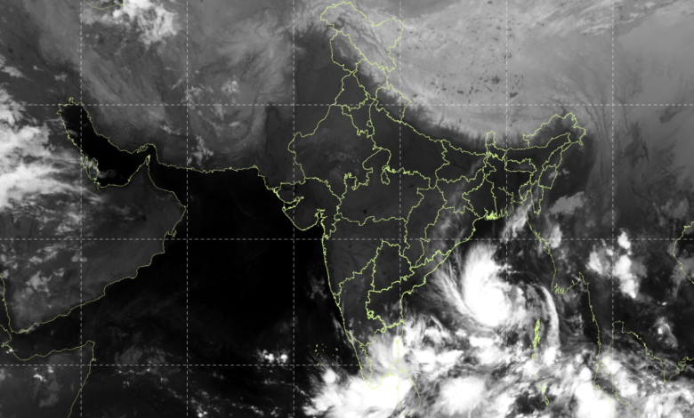
Cyclonic Storm Arnab has intensified over the eastcentral and adjoining westcentral Bay of Bengal, prompting the India Meteorological Department (IMD) to issue a red message for the Andhra Pradesh and adjoining south Odisha coasts. The storm is moving towards India’s eastern coastline and is expected to strengthen further before making landfall over Andhra Pradesh on the forenoon of October 28, 2026.
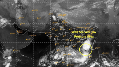
According to the IMD’s latest bulletin issued at 5:30 am on October 26, Cyclone Arnab, pronounced Ornab, developed from a deep depression that moved nearly westwards at a speed of 15 kmph during the preceding six hours.
The cyclonic storm was centred near latitude 15.4°N and longitude 88.9°E over the eastcentral and adjoining westcentral Bay of Bengal. It was located approximately 650 km east-southeast of Visakhapatnam, 730 km east-southeast of Kakinada, 830 km east of Machilipatnam and 910 km east of Bapatla in Andhra Pradesh. The system was also around 590 km northwest of Sri Vijaya Puram in the Andaman and Nicobar Islands.
Cyclone Arnab Likely to Intensify Into a Very Severe Storm
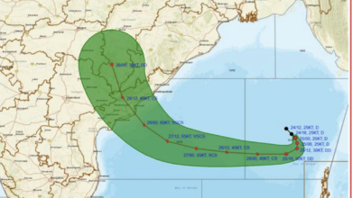
Meteorologists have forecast further intensification of Cyclone Arnab over the Bay of Bengal. The system is very likely to move west-northwestwards and intensify into a severe cyclonic storm by midnight on October 26. It is then expected to strengthen into a very severe cyclonic storm over the westcentral Bay of Bengal on October 27.
The cyclone is subsequently forecast to change direction towards the northwest and approach the Andhra Pradesh coast.
According to the IMD, Cyclone Arnab is likely to cross the Andhra Pradesh and Yanam coasts between Bapatla and Visakhapatnam by the forenoon of October 28. At landfall, the storm is expected to produce maximum sustained wind speeds of 115–125 kmph, with gusts reaching up to 140 kmph.
The projected wind speeds indicate the potential for significant damage in coastal areas, particularly in locations exposed to strong winds, heavy rainfall and rough sea conditions. Coastal communities and authorities are expected to closely monitor subsequent IMD bulletins and advisories.
Heavy Rainfall Forecast Across Several States
Cyclone Arnab is expected to bring widespread rainfall to Andhra Pradesh and adjoining regions as it approaches the coast and moves inland. Heavy to very heavy rainfall is forecast in affected areas, with the possibility of extremely heavy rainfall in some locations depending on the cyclone’s track and intensity.
The weather system could also influence rainfall patterns over Odisha and Chhattisgarh as it moves inland after landfall. Its remnants are subsequently expected to travel further north and weaken into a low-pressure system, potentially bringing substantial rainfall to parts of central and northern India.
According to the weather forecast outlined for the developing system, rainfall activity could extend into Madhya Pradesh and Uttar Pradesh in the days following landfall.
The exact distribution and intensity of rainfall will depend on the cyclone’s movement after crossing the coast, its rate of weakening and the interaction of its remnants with prevailing atmospheric conditions.
Uttar Pradesh, Uttarakhand and Nepal May See Heavy Rain Later This Week
The possible northward movement of Cyclone Arnab’s remnants has raised the prospect of another spell of widespread rainfall across parts of northern India towards the end of October.
Weather forecasts indicate that October 30 and 31 could bring heavy to very heavy rainfall to parts of Uttar Pradesh and Uttarakhand, as well as a large area of Nepal, subject to the system’s subsequent track and weakening pattern.
If the remnants retain sufficient moisture while moving northwards, several regions could experience prolonged rainfall, potentially affecting transport, agriculture and routine activities. However, the rainfall forecast for these areas will need to be confirmed through updated IMD forecasts as the system progresses inland.
The potential spread of rainfall from the eastern coast towards central and northern India highlights the wider weather impact that a strong Bay of Bengal cyclone can produce beyond its immediate landfall zone.
Authorities and Coastal Residents Advised to Remain Alert
With Cyclone Arnab forecast to intensify into a very severe cyclonic storm, the coming 48 hours will be crucial for monitoring its development and likely impact.
Residents in coastal Andhra Pradesh and adjoining south Odisha should follow official weather warnings and instructions issued by local administrations. Fishermen and other maritime operators should adhere to applicable IMD advisories regarding sea conditions and restrictions on fishing activities.
Authorities will need to monitor vulnerable coastal settlements, low-lying areas and locations prone to flooding as the cyclone approaches.
Cyclone Arnab is expected to reach its peak intensity before landfall on October 28. Its subsequent movement will determine the extent of rainfall across Odisha, Chhattisgarh, Madhya Pradesh, Uttar Pradesh and neighbouring regions. Further updates from the IMD will be essential to establish the precise timing, intensity and geographical spread of the expected weather impacts.