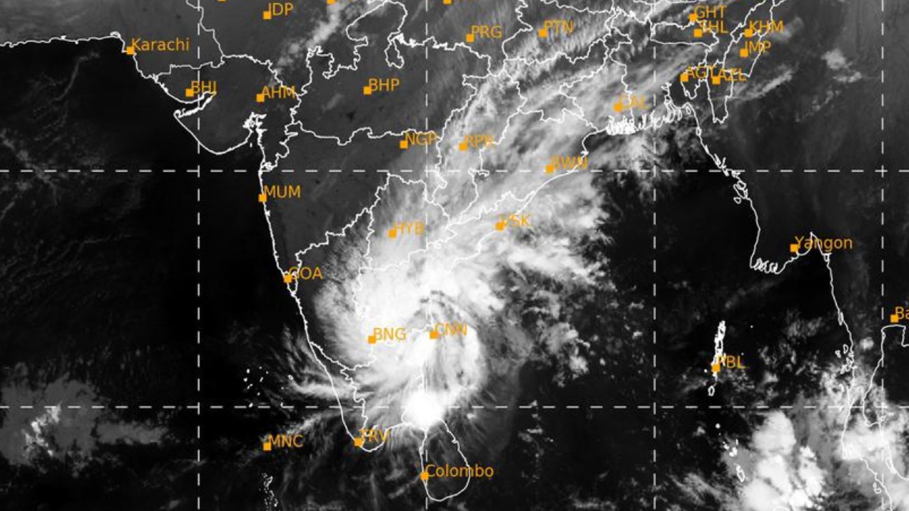
Very Severe Cyclonic Storm “NIVAR” crossed coast near Puducherry and weakened into a Severe Cyclonic Storm
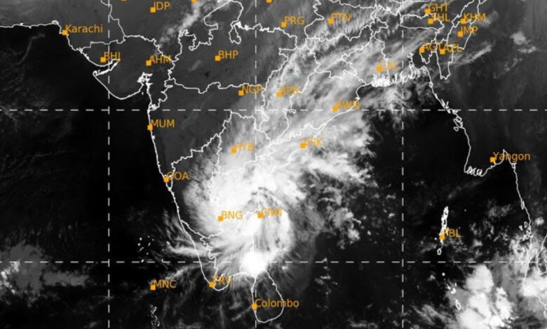
The very severe cyclonic storm ‘NIVAR’ over Southwest Bay of Bengal moved west-north-westwards with a speed of 09 kmph during past six hours and crossed Tamilnadu & Puducherry coasts near Puducherry (near lat. 12.1°N and long. 79.9°E) during 2330 IST of 25 th Nov to 0230 IST of 26th Nov as a very severe cyclonic storm with estimated wind speed of 120-130 kmph gusting to 145 kmph. It weakened into a Severe Cyclonic Storm with a wind speed of 100- 110 kmph gusting to 120 kmph. The Severe Cyclonic Storm ‘NIVAR’ would continue to move northwestwards and weaken further into a cyclonic storm.
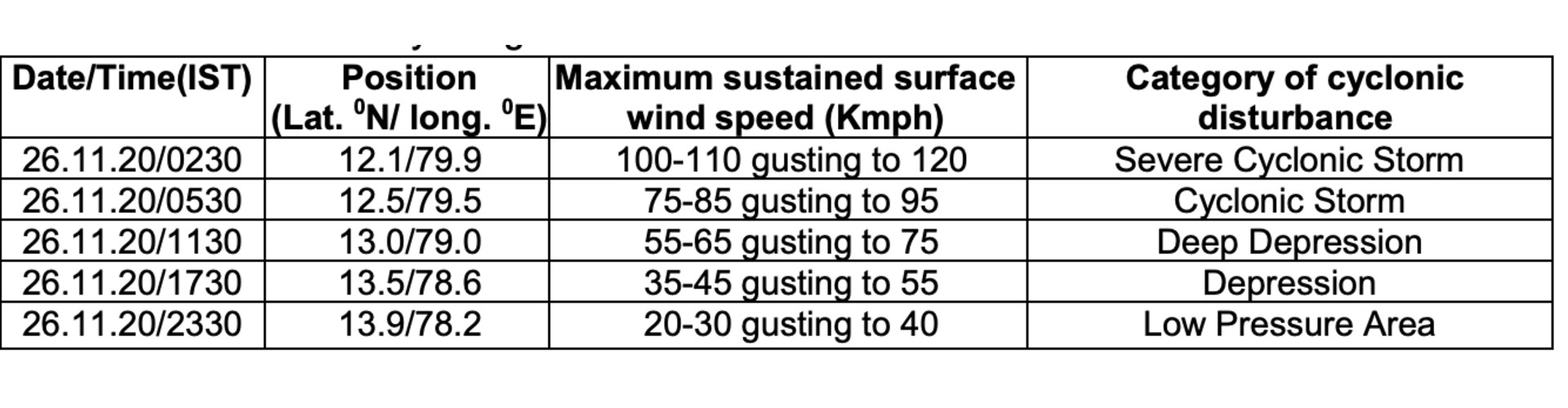
Forecast track and intensity are given below:
Warnings:
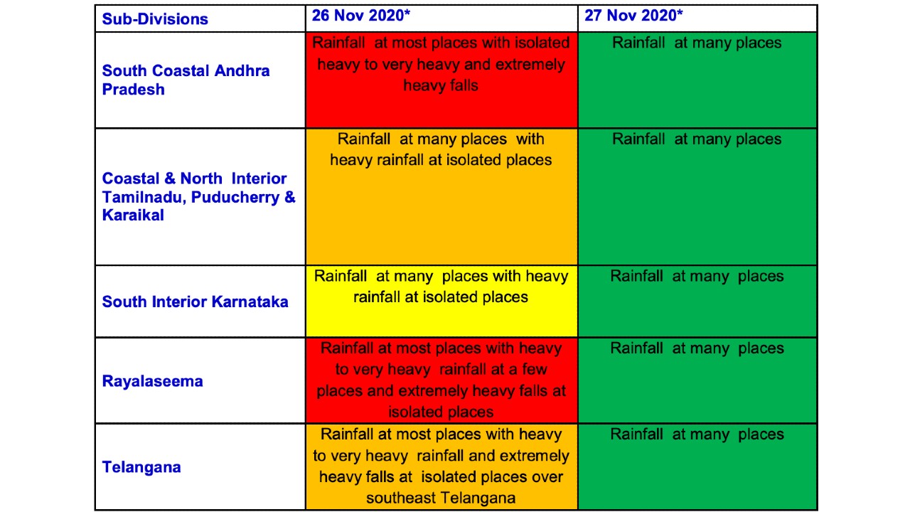
(i) Rainfall Fairly widespread to widespread rainfall/thunderstorm activity very likely over coastal and north interior Tamilnadu, Puducherry & Karaikal, south coastal Andhra Pradesh and Rayalaseema and southeast Telangana during 26th November, 2020. Heavy to very heavy rainfall at a few places and isolated extremely heavy rainfall activity very likely over Ranipet, Tiruvannamalai, Tirupattur, Vellore districts of Tamilnadu; Chittoor, Kurnool, Prakasam and Cuddappa districts of Andhra Pradesh and adjoining southeast Telangana on 26th November, 2020.
(ii) Wind warning
Gale wind speed reaching 100-110 kmph gusting to 120 kmph is prevailing over Southwest Bay of Bengal. It will gradually decrease becoming 75-85 kmph gusting to 95 kmph by morning and squally wind speed reaching 45-55 kmph gusting to 65 kmph by noon of 26th Nov. Gale wind speed reaching 100-110 kmph gusting to 120 kmph is prevailing along & off Puducherry, Villupuram & Chengalpattu districts of north Tamil Nadu. It will gradually decrease becoming 75-85 kmph gusting to 95 kmph by morning and squally wind speed reaching 35-45 kmph gusting to 55 kmph by noon of 26th Nov.
Squally wind speed reaching 50-60 gusting to 70 kmph very likely over Nagapattinam, Karaikal, Myladuthurai, Cuddalore, Tiruvarur, Kanchipuram, Chennai & Tiruvallur districts of Tamilnadu during next 06 hours and gradual decrease thereafter.
Squally wind speed reaching 40-50 kmph gusting to 60 kmph along & off south Tamilnadu and south Andhra Pradesh coast and adjoining westcentral Bay of Bengal and Gulf of Mannar during next 06 hours and gradual decrease thereafter.
(iii) Sea condition
Sea condition is very high to phenomenal over Southwest Bay of Bengal, along & off Tamil Nadu, Puducherry and adjoining south Andhra Pradesh coasts and rough to very rough over Gulf of Mannar. It will gradually become rough to very rough by noon of 26th Nov and improve further by evening of 26th Nov. (iv) Strom Surge Warning
Tidal wave of about 1 m height above the astronomical tide is very likely to inundate the low lying areas of north coastal districts of Tamilnadu (Villupuram and Kanchipuram districts) during next 03 hours. (v) (a) Damage expected over Nagapattinam, Myladuthurai, Cuddalore, , Villupuram & Chengalpattu districts of Tamilnadu and Karaikal & Puducherry during next 03 hours: Total destruction of thatched houses/ extensive damage to kutcha houses. Some damage to old pucca houses. Potential threat from flying objects.
Bending/ uprooting of power and communication poles.
Major damage to Kutcha and Pucca roads. Flooding of escape routes. Disruption of railways, overhead power lines and signaling systems.
Widespread damage to standing crops, plantations, orchards, falling of green coconuts and tearing of palm fronds. Blowing down of bushy trees like mango.
Small boats, country crafts may get detached from moorings.
Visibility severely affected. (b) Damage expected over Tiruvarur, Kanchipuram, Chennai, Tiruvallaur districts of Tamilnadu and adjoining Andhra Pradesh during next 03 hours:
Damage to thatched houses/ huts with possibility of roof tops being blown off and unattached metal sheets may fly.
Damage to power and communication lines.
Damage to Kutcha and some damage to Pucca roads. Flooding of escape routes.
Breaking of tree branches, uprooting of trees. Severe damage to banana and papaya trees, horticulture and crops & orchards. Large dead limbs blown from trees.
Major damage to coastal crops. Damage to embankments/ salt pans.
(vi) Fishermen Warning & Action Suggested during next 12 hours:
Total suspension of fishing operations.
People in affected areas to remain in safe places and indoors.
Judicious regulation of rail, road and air traffic.
Movement in motor boats and small ships unsafe.
(vii) POST LANDFALLOUTLOOK FOR INTERIOR DISTRICTS (RANIPET, TIRUVANNAMALAI, TIRUPATTUR, VELLORE AND CHITTOOR)
1. The system is likely to maintain its cyclone intensity for next 06 hours and weaken gradually.
2. Under its influence rainfall at most/many places with heavy to very heavy falls at a few places with isolated extremely heavy falls likely to occur over Ranipet, Tiruvannamalai, Tirupattur, Vellore districts of Tamilnadu and Chittoor, Kurnool, Prakasam; Cuddappa districts of Andhra Pradesh and adjoining southeast Telangana on 26th Nov. Heavy to very heavy rainfall at isolated paces likely over remaining districts of north interior Tamilnadu, south Andhra Pradesh and southeast Telangana. Spatial rainfall distribution: Isolated: ≤25%, A few: 26-50%, Many: 51-75%, Most: 76-100% Rainfall amount (mm): Heavy rain: 64.5 – 115.5, Very heavy rain: 115.6 – 204.4, Extremely heavy rain: 204.5 or more.
3. Gale wind speed reaching 65-75 kmph gusting to 85 kmph very likely to prevail over interior districts (Ranipet, Tiruvannamalai, Tirupattur, Vellore) of Tamilnadu and Chittoor district of Andhra Pradesh during 26th Nov early morning to forenoon.
4. Damage expected over Ranipet, Tiruvannamalai, Tirupattur, Vellore districts of Tamilnadu and Chittoor, Kurnool, Prakasam and Cuddappa districts of Andhra Pradesh: Partial damage to thatched houses/ huts with possibility of roof tops being blown off and unattached metal sheets may fly.
Partial damage to power and communication lines.
Damage to Kutcha and some damage to Pucca roads. Flooding of escape routes.
Breaking of tree branches, uprooting of small trees. Damage to banana and papaya trees, horticulture and crops & orchards. 5. People are advised to remain indoors/in safe places and cooperate with state government officials and disaster management agencies.