Southwest Monsoon Advances Over Andaman Sea; Kerala Likely to Receive Monsoon by May 26
The India Meteorological Department (IMD) on Saturday announced a significant advancement of the southwest monsoon over parts of the southeast Arabian Sea, southwest and southeast Bay of Bengal, the Andaman Sea, and the entire Nicobar Islands. The monsoon has also covered some parts of the Andaman Islands, including Sri Vijaya Puram, marking the official onset of the seasonal rainfall system over the region on May 16, 2026.
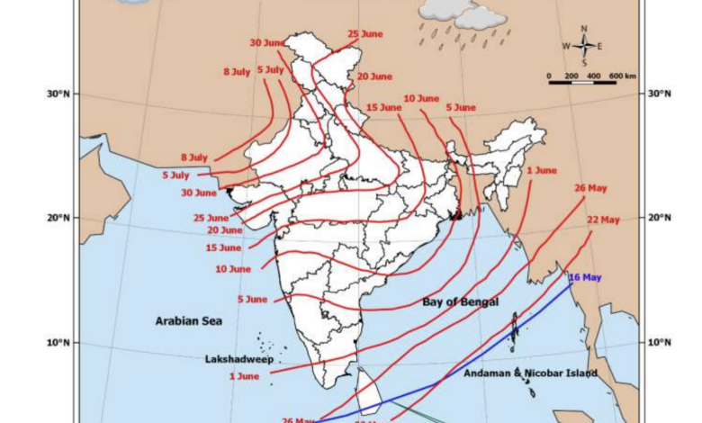
According to the IMD, conditions remain favourable for the further advance of the southwest monsoon into additional parts of the southeast Arabian Sea, Bay of Bengal, and the remaining Andaman Islands during the next three to four days. The weather agency has also forecast that the monsoon is likely to set in over Kerala on May 26, with a model error margin of plus or minus four days.
The Northern Limit of Monsoon currently passes through coordinates 5°N/75°E, 6°N/79°E, 8°N/85°E, 10.5°N/90°E, 13.5°N/95°E and 15.5°N/98°E.
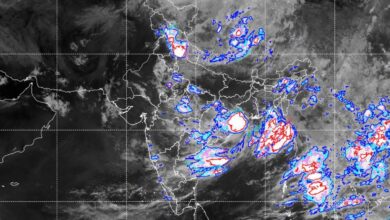
IMD officials said all meteorological conditions necessary for the monsoon advance had been satisfied over the Andaman region. During the past two days, widespread rainfall activity was observed over the Nicobar Islands and adjoining Andaman Islands. Westerly winds strengthened to around 35 kmph with gusts reaching up to 45 kmph, while the wind system extended up to 4.5 km above mean sea level. Additionally, Outgoing Longwave Radiation (OLR) values remained below 200 W/m², indicating persistent convective cloud formation favourable for monsoon progression.
While the monsoon has started advancing over southern seas, large parts of northwest and central India are expected to continue facing intense heatwave conditions over the coming week. The IMD has warned that heatwave to severe heatwave conditions are likely to prevail across isolated to some pockets of Uttar Pradesh, Rajasthan, Madhya Pradesh, Punjab, Haryana and Delhi during the next several days.
Severe heatwave conditions are particularly likely over West Rajasthan on May 21 and 22 and over Uttar Pradesh between May 19 and 22. Heatwave conditions are also expected over Vidarbha, East Rajasthan and Chhattisgarh during the latter half of the week.
The highest maximum temperature in the country on Friday was recorded at Amravati, where mercury touched 45.6 degrees Celsius. Maximum temperatures between 40°C and 45°C were reported across many parts of central India, Gujarat, Rajasthan and adjoining Haryana.
At the same time, the IMD has forecast widespread rainfall activity accompanied by thunderstorms, lightning and gusty winds across several regions of the country. Northeast India is likely to witness isolated heavy to very heavy rainfall during the next week. Heavy rainfall has been forecast over Arunachal Pradesh, Assam, Meghalaya, and the states of Nagaland, Manipur, Mizoram and Tripura on multiple days between May 16 and May 22.
South Peninsular India is also expected to receive widespread rainfall. Light to moderate rain accompanied by thunderstorms and gusty winds is likely over Kerala and Mahe, Lakshadweep, Rayalaseema, Coastal Andhra Pradesh and South Interior Karnataka during the next few days. Isolated heavy rainfall is likely over Tamil Nadu, Kerala, Karnataka and Puducherry through May 19.
The IMD has also predicted thundersquall activity with wind speeds reaching 50-60 kmph gusting to 70 kmph over Rayalaseema on May 19 and 20. Hailstorm activity is likely at isolated places over South Interior Karnataka on May 16.
In eastern India, the Andaman and Nicobar Islands are likely to witness widespread rainfall along with thunderstorms and gusty winds throughout the week. Heavy to very heavy rainfall is likely over the islands on May 16 and 17. Similar conditions are expected over Sub-Himalayan West Bengal and Sikkim, with isolated very heavy rainfall likely on May 17.
Gangetic West Bengal, Bihar, Jharkhand and Odisha are also likely to receive scattered to widespread rainfall accompanied by thunderstorms and gusty winds. Thundersquall conditions with wind speeds up to 70 kmph are likely over Bihar and Jharkhand on selected days.
Northwest India may also witness intermittent thunderstorm activity. Jammu and Kashmir is likely to receive light to moderate rainfall accompanied by thunderstorms and gusty winds on May 16, 19 and 20, while Uttarakhand may witness isolated thunderstorm activity on May 16.
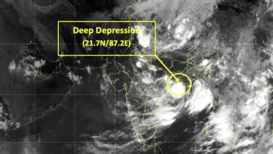
The IMD said a number of active weather systems are influencing the current weather pattern across the country. A low-pressure area persists over the southwest and adjoining west-central Bay of Bengal, with an associated cyclonic circulation extending up to 4.5 km above mean sea level. A western disturbance remains active over Jammu and adjoining north Pakistan, while multiple upper-air cyclonic circulations are present over Rajasthan, Uttar Pradesh and Vidarbha regions.
During the past 24 hours ending at 8:30 am on May 16, heavy to very heavy rainfall was recorded at isolated places over Sub-Himalayan West Bengal, Assam and Meghalaya. Heavy rainfall was also reported from Chhattisgarh, Sikkim and Puducherry.
Among major rainfall observations, Oodlabari Tea Estate in Jalpaiguri district recorded 18 cm rainfall, while Karimganj in Assam received 17 cm rainfall. Puducherry recorded up to 8 cm rainfall during the period.
Strong gusty winds were also observed in several regions. Kalyani in Gangetic West Bengal recorded the highest wind speed of 76 kmph, while gusty winds exceeding 50 kmph were also reported from Odisha, Jharkhand, East Madhya Pradesh and parts of Northeast India.
The IMD has issued warnings for fishermen, advising them not to venture into several parts of the Bay of Bengal and Arabian Sea during the coming days due to rough sea conditions and strong winds. Fishermen have been specifically warned against venturing into the Andaman Sea, south Bay of Bengal, Gulf of Mannar, Lakshadweep region and areas along the Kerala and Karnataka coasts.
Meanwhile, the weather department has forecast a gradual rise in maximum temperatures by 3°C to 5°C over the plains of northwest India till May 20, after which temperatures are likely to stabilise. Maharashtra and Gujarat may witness a slight fall in temperatures between May 19 and 22.
The advancing monsoon, combined with simultaneous heatwave conditions over northern and central India, highlights the contrasting weather patterns currently prevailing across the country as India moves closer to the full onset of the 2026 southwest monsoon season.