Cyclone Arnab Landfall Nears Completion; IMD Issues Red Alert for Andhra Pradesh and Odisha
Cyclone Arnab Landfall Nears Completion; IMD Issues Red Alert for Andhra Pradesh and Odisha

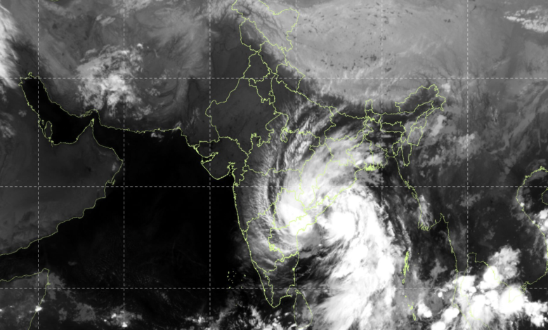
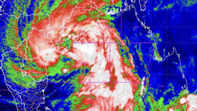
Very Severe Cyclonic Storm Arnab continued its landfall process along the Andhra Pradesh coast early on Wednesday, October 28, with the India Meteorological Department (IMD) warning of destructive winds, torrential rainfall, coastal inundation and flash floods across affected regions. In its Special Bulletin No. 16, issued at 4:30 AM, the IMD said the storm was moving slowly northwestwards and was positioned close to the Andhra Pradesh and Yanam coasts.
At 2:30 AM, the cyclone was centred over the west-central Bay of Bengal near latitude 16.4°N and longitude 82.0°E, approximately 30 km east of Narsapur, 45 km south-southwest of Yanam, 70 km south-southwest of Kakinada and 90 km east-northeast of Machilipatnam. The storm had moved northwestwards at around 3 kmph during the preceding three hours.
The IMD said Arnab was interacting with the land surface, with its northern spiral rainbands extending inland. The landfall process was expected to continue for another three hours from the bulletin’s observation time. The system was forecast to cross the Andhra Pradesh and Yanam coasts between Bapatla and Visakhapatnam, close to the south of Yanam, as a very severe cyclonic storm.
Maximum sustained wind speeds of 125–135 kmph, gusting to 150 kmph, were expected during the landfall period. The cyclone was under continuous surveillance by the Doppler Weather Radar at Machilipatnam.
Cyclone to Weaken Gradually After Crossing Coast
The IMD forecast indicates that Arnab will weaken progressively after landfall as it moves inland. By 5:30 AM on October 28, wind speeds were forecast to decrease to 115–125 kmph, gusting to 135 kmph, while the system would retain its very severe cyclonic storm classification.
By 11:30 AM, the cyclone was expected to weaken into a cyclonic storm, with winds of 80–90 kmph and gusts up to 100 kmph. By the evening, it was forecast to become a deep depression, with winds of 50–60 kmph, gusting to 70 kmph. The system was expected to weaken further into a depression overnight and become a well-marked low-pressure area by late October 29.
Despite the expected weakening, the IMD warned that heavy rainfall, strong winds and flooding could continue across Andhra Pradesh and adjoining Odisha after landfall.
Odisha Faces Red Alert for Extremely Heavy Rainfall
The IMD issued a red warning for Gajapati and Ganjam districts of Odisha for October 28, warning of heavy to very heavy rainfall at a few places, with extremely heavy rainfall likely at isolated locations. Thunderstorms accompanied by lightning and gusty winds of 40–50 kmph, reaching 60 kmph, were also forecast.
An orange warning was issued for Puri, Khordha, Jagatsinghpur, Cuttack, Nayagarh, Kandhamal, Rayagada, Koraput and Malkangiri districts, where heavy to very heavy rainfall was likely at isolated places. Thunderstorms, lightning and strong gusty winds were also expected in several districts.
A yellow warning covered several other districts, including Balasore, Bhadrak, Kendrapara, Angul, Deogarh, Dhenkanal, Jajpur, Keonjhar, Mayurbhanj, Nabarangpur, Nuapada, Balangir, Subarnapur, Kalahandi and Boudh, where isolated heavy rainfall and thunderstorms were forecast.
The weather threat was expected to persist on October 29. The IMD issued a fresh red warning for Gajapati, Ganjam, Rayagada, Koraput, Nabarangpur and Malkangiri, forecasting heavy to very heavy rainfall at several places and extremely heavy rainfall at isolated locations. Gusty winds of 60–80 kmph, reaching 90 kmph, were also likely at isolated places in these districts.
An orange warning was issued for Kalahandi, Kandhamal, Nuapada, Balangir, Bargarh, Puri, Khordha, Subarnapur, Boudh and Nayagarh. Further rainfall warnings remained in place for October 30, indicating that the storm’s effects would continue after the system weakened.
Heavy Rainfall Recorded in Andhra Pradesh and Odisha
The cyclone has already triggered intense rainfall across coastal Andhra Pradesh. According to the IMD’s hourly update, several locations in Anakapalli, Vizianagaram and Visakhapatnam districts recorded more than 200 mm of rainfall between 8:30 AM on October 27 and 4 AM on October 28.
Kannuripalem in Anakapalli district recorded 261.5 mm, while KVBR School in Vizianagaram received 259.74 mm. The 16th Police Battalion area in Visakhapatnam recorded 259.06 mm, highlighting the intensity of the downpour.
In Odisha, rainfall recorded up to 4:30 AM on October 28 included 94 mm at Gopalpur, 67 mm at Puri, 38 mm at Bhubaneswar and 22.4 mm at Chandbali.
The IMD also highlighted a moderate-to-high flash flood risk over selected watersheds and surrounding areas in Balangir, Nuapada, Malkangiri, Koraput, Nabarangpur, Rayagada, Puri, Gajapati, Ganjam, Kalahandi and Kandhamal districts over the following 36 hours. Saturated soil, intense rainfall and surface runoff could cause inundation in low-lying areas.
Strong Winds, Flooding and Transport Disruptions Expected
The IMD warned that strong winds could damage plantations, horticultural crops, standing crops, huts and vulnerable structures. Trees and branches could fall, while electricity and communication lines could suffer damage. Roads, embankments and salt pans could also be affected.
Heavy rainfall could lead to waterlogging, flooding of underpasses, reduced visibility, traffic congestion and longer travel times in urban areas. Localised landslides and mudslides were also possible, particularly in vulnerable locations.
Marine and inland water transport could be disrupted, while small boats, trawlers, ships and offshore operations could face hazardous conditions.
The IMD warned that gale-force winds would continue along the Andhra Pradesh and Yanam coasts during the landfall period before gradually weakening. Southern Odisha districts, including Ganjam, Gajapati, Nabarangpur, Rayagada, Koraput and Malkangiri, were expected to experience strong winds, potentially reaching 60–70 kmph with gusts up to 80 kmph.
Sea conditions along the Andhra Pradesh and Yanam coasts were described as phenomenal, with gradual improvement expected through Wednesday. Rough to very rough seas were also forecast along adjoining Odisha, West Bengal and north Tamil Nadu coastal areas.
Fishermen were advised not to venture into the west-central Bay of Bengal, along the Andhra Pradesh–Odisha coasts, and into the northwest Bay of Bengal along the West Bengal coast until October 29. Odisha ports were instructed to keep Local Cautionary Signal No. III hoisted.
IMD Advises Residents to Take Precautions
The weather department urged residents in affected areas to remain alert, monitor official updates and move to safer locations when advised by authorities. People were advised to stay indoors, avoid unnecessary travel, keep away from trees during thunderstorms and avoid taking shelter in vulnerable structures.
Residents were also advised to unplug electrical appliances during thunderstorms, stay away from water bodies and objects that conduct electricity, and check traffic advisories before travelling.
With the landfall process underway and heavy rainfall expected to persist across Andhra Pradesh and Odisha, the immediate concerns remain coastal inundation, flash flooding, wind damage and disruption to transport and essential services. The IMD continues to monitor Arnab as it moves inland and gradually weakens.