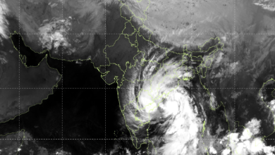
Cyclone Arnab’s Landfall Nears Completion Along Andhra Pradesh Coast; IMD Warns of Flash Floods Across Four States
Very Severe Cyclonic Storm Brings Winds of Up to 140 kmph; Storm Surge Threatens Low-Lying Coastal Areas as Flash Flood Risk Spreads Across Andhra Pradesh, Odisha, Telangana and Chhattisgarh

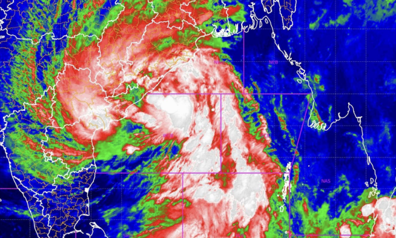
The IMD said the rear portion of the cyclone’s wall cloud region was expected to enter the coastal area within the next hour from the 6:30 am observation, completing the landfall process. Despite the expected completion of landfall, the agency warned that hazardous weather conditions would continue, with strong winds forecast over the landfall area for the next two hours and a storm surge likely to inundate low-lying areas of Andhra Pradesh.
The cyclone was forecast to move slowly northwestwards initially and then north-northwestwards.
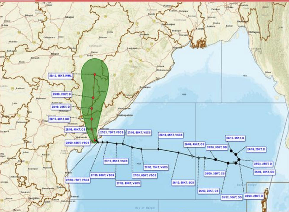
Cyclone Arnab’s Centre Lies Over Andhra Pradesh and Yanam Coasts
According to the IMD’s latest observation at 6:30 am IST on October 28, the centre of Cyclone Arnab was located near latitude 16.4°N and longitude 81.9°E, over the Andhra Pradesh and Yanam coasts, to the south of Yanam.
The system continued to maintain wind speeds of 115–125 kmph near its centre, with gusts reaching 140 kmph. These conditions posed a significant threat to coastal communities, infrastructure, power lines, trees, temporary structures and transportation networks.
The IMD stated that the remaining portion of the wall cloud region would move into the coastal area within approximately one hour, completing the landfall process. The agency forecast that winds of 115–125 kmph, gusting up to 140 kmph, would continue over the landfall area for the following two hours, gradually weakening thereafter.
The intensity and duration of the winds could cause damage even after the cyclone’s centre moves inland. Residents in vulnerable coastal areas were urged to remain alert and follow instructions issued by local authorities.
Storm Surge Threatens Low-Lying Coastal Areas
The IMD warned that a storm surge of 1.0 to 1.5 metres above the astronomical tide was likely to inundate low-lying areas of Andhra Pradesh during the three hours following the 6:30 am observation.
Storm surges occur when powerful cyclone winds push seawater towards the coast, raising water levels beyond normal tidal conditions. When combined with heavy rainfall and poor drainage, these conditions can lead to coastal inundation, waterlogging and flooding in vulnerable settlements.
The surge was expected to decrease after the initial three-hour period. However, the agency’s warning highlighted the immediate danger facing low-lying coastal areas during the landfall phase.
The Indian National Centre for Ocean Information Services (INCOIS) also provided storm surge graphics for Cyclone Arnab to support the assessment of coastal inundation risks.
Heavy Rainfall Recorded Across Andhra Pradesh and Odisha
The cyclone has already produced substantial rainfall across several coastal locations. The rainfall figures included in the IMD bulletin highlighted significant precipitation at stations in Andhra Pradesh and Odisha.
Visakhapatnam’s Waltair station recorded 217 mm of rainfall, followed by Kalingapatnam with 147 mm and Tuni with 123 mm. Kakinada received 118 mm, while Machilipatnam’s Franchpet station recorded 115 mm.
In Odisha, Gopalpur recorded 94 mm of rainfall and Puri received 72 mm.
Such intense rainfall can saturate the soil, overwhelm drainage systems and increase the likelihood of rapid runoff into rivers, streams and low-lying settlements. The danger is particularly high in areas where heavy precipitation coincides with strong winds, elevated coastal water levels and overflowing drainage channels.
The IMD has therefore extended its warnings beyond the immediate landfall zone, highlighting the possibility of flash floods in multiple districts across eastern and central India.
Flash Flood Threat in Andhra Pradesh and Yanam
The IMD issued a Persistent Flash Flood Threat warning valid until 11:30 am IST on October 28, indicating a moderate to high flash flood threat over selected watersheds and neighbouring areas in Coastal Andhra Pradesh and Yanam during the following six hours.
The districts identified under this warning were:
-
Sri Alluri Sitharamaraju
-
Anakapalli
-
Kakinada
-
Krishna
-
Vizianagaram
-
Visakhapatnam
The weather agency warned that surface runoff and inundation could occur in areas with fully saturated soil and in low-lying locations within the identified areas of concern.
The warning is significant because rainfall falling on already saturated ground can rapidly flow into local drainage channels and settlements rather than being absorbed by the soil. This can lead to sudden flooding, particularly in vulnerable watersheds and areas with restricted drainage.
Residents in the identified districts should avoid flooded roads, streams and waterlogged underpasses and follow official instructions regarding movement and evacuation.
Flash Flood Risk Extends Across Four States
In a separate warning valid until 5:30 am IST on October 29, the IMD forecast a moderate to high flash flood risk over selected watersheds and neighbourhoods across Andhra Pradesh, Odisha, Chhattisgarh and Telangana during the following 24 hours.
In Andhra Pradesh and Yanam, the risk areas include Bapatla, Guntur, NTR, Krishna, Eluru, East Godavari, Kakinada, Sri Alluri Sitharamaraju, Visakhapatnam, Vizianagaram, Anakapalli, Parvathipuram Manyam and West Godavari districts.
In Odisha, the warning covers Koraput, Nawarangpur, Rayagada, Kalahandi, Nawapara, Balangir, Kandhamal, Ganjam, Gajapati, Khurda, Nayagarh, Puri, Sambalpur, Angul, Deogarh, Boudh, Bargarh, Jharsuguda, Sundargarh and Sonepur districts.
In Chhattisgarh, the districts under the flash flood risk warning are Sukma, Bijapur, Bastar, Kondagaon, Kanker, Dhamtari and Gariaband.
In Telangana, Khammam, Bhadradri Kothagudem and Mulugu districts have been identified as areas of concern.
The IMD cautioned that surface runoff and inundation could occur in fully saturated soils and low-lying areas across these regions due to expected rainfall during the 24-hour forecast period.
The spread of the warning across four states indicates that the effects of Cyclone Arnab may extend well beyond its immediate coastal landfall zone. Heavy rainfall associated with the system could trigger flooding in inland watersheds and areas with vulnerable drainage infrastructure.
Coastal Winds Pose Risks to Infrastructure and Fishing Communities
The IMD’s intensity assessment indicated that winds of 115–125 kmph, gusting up to 140 kmph, prevailed along and off the coasts of West Godavari, including Konaseema, Kakinada district and Yanam in the Union Territory of Puducherry.
Such powerful winds can uproot trees, damage roofs, bring down power lines and disrupt road and communication networks. Temporary structures and buildings that are not designed to withstand severe wind conditions face a heightened risk of damage.
Fishing communities also face dangerous marine conditions during the cyclone’s landfall. The IMD included fishermen warning graphics in its bulletin, underlining the importance of marine safety precautions during the storm.
People should stay away from exposed coastal areas and avoid venturing into the sea until conditions improve and official restrictions are lifted.
Authorities Urged to Maintain Vigilance as Cyclone Moves Inland
Cyclone Arnab was forecast to move slowly northwestwards initially before turning north-northwestwards. Although the landfall process was expected to conclude shortly after the latest observation, the risks from strong winds, heavy rainfall, storm surges and flash floods were expected to persist.
The IMD’s warnings highlight two immediate priorities: protecting people in the cyclone-affected coastal belt and preparing vulnerable inland districts for possible flash flooding.
Residents should monitor official weather bulletins, follow instructions issued by district administrations and avoid crossing flooded roads or streams. People in low-lying areas should remain prepared for waterlogging and localised inundation, while emergency services should continue monitoring vulnerable watersheds and drainage systems.
With the cyclone’s landfall nearing completion, the focus is shifting towards managing its continuing impacts across Andhra Pradesh and neighbouring states. The coming hours remain critical as intense winds and rainfall gradually move away from the coast but continue to threaten vulnerable communities.