
Severe Cyclonic Storm ‘Montha’ Barrels Toward Andhra Pradesh Coast; IMD Issues Orange Alert for Heavy Rains and Gale Winds
The India Meteorological Department (IMD) has issued an urgent orange alert as Cyclonic Storm “Montha” (pronounced Mon-Tha) intensifies over the southwest and adjoining southeast Bay of Bengal, poised to slam into the Andhra Pradesh coast as a severe cyclonic storm by Tuesday evening. In a parallel development, a depression lingering over the eastcentral Arabian Sea is expected to trigger heavy downpours across western and southern coastal states.
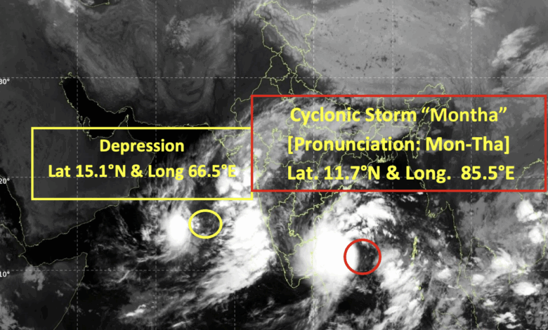
According to IMD’s National Bulletin No. 26, released at 0400 hours IST on Monday, the storm is currently centered near 11.7°N, 85.5°E—approximately 600 km east-southeast of Chennai, 680 km south-southeast of Kakinada, and 710 km south-southeast of Visakhapatnam. It has been tracking west-northwest at 16 kmph over the past three hours and is forecast to maintain this path initially before veering northwest and then north-northwest, gathering strength.Intensifying Path and Landfall Prediction
Meteorologists predict “Montha” will escalate into a severe cyclonic storm by Tuesday morning (October 28), with maximum sustained winds of 90-100 kmph gusting to 110 kmph. The system is very likely to make landfall between Machilipatnam and Kalingapatnam, around Kakinada in Andhra Pradesh, during the evening or night of October 28. Post-landfall, it is expected to weaken rapidly into a cyclonic storm by Wednesday morning and further into a depression by Wednesday night.
The IMD’s forecast track, based on observations at 1800 UTC (2330 IST) on October 26, outlines the following progression:
|
Date/Time (IST)
|
Position (Lat. °N / Long. °E)
|
Max Sustained Wind Speed (kmph, gusting)
|
Category
|
|---|---|---|---|
|
27.10.25 / 0230
|
11.7 / 85.5
|
65-75 (85)
|
Cyclonic Storm
|
|
27.10.25 / 0530
|
12.2 / 85.2
|
70-80 (90)
|
Cyclonic Storm
|
|
27.10.25 / 1130
|
12.9 / 84.5
|
75-85 (95)
|
Cyclonic Storm
|
|
27.10.25 / 1730
|
13.6 / 83.9
|
80-90 (100)
|
Cyclonic Storm
|
|
27.10.25 / 2330
|
14.4 / 83.4
|
85-95 (105)
|
Severe Cyclonic Storm
|
|
28.10.25 / 1130
|
15.7 / 82.8
|
90-100 (110)
|
Severe Cyclonic Storm
|
|
28.10.25 / 2330
|
17.2 / 82.2
|
90-100 (110)
|
Severe Cyclonic Storm
|
|
29.10.25 / 1130
|
19.0 / 81.6
|
60-70 (80)
|
Cyclonic Storm
|
|
29.10.25 / 2330
|
20.8 / 81.0
|
40-50 (60)
|
Depression
|
Heavy Rainfall and Gale Winds to Batter Coasts
The storm is set to unleash widespread heavy to very heavy rainfall, with isolated extremely heavy falls exceeding 20 cm, across Andhra Pradesh, Yanam (Puducherry), and south Odisha from October 28. North coastal Andhra Pradesh and Odisha could see lingering heavy rains on October 29, while Telangana, Chhattisgarh, Gangetic West Bengal, Jharkhand, Bihar, and sub-Himalayan West Bengal/Sikkim face isolated heavy spells through October 30.
Gale-force winds of 90-100 kmph (gusting to 110 kmph) are expected over the westcentral and northwest Bay of Bengal from Tuesday morning, escalating along Andhra Pradesh and Yanam coasts to peak intensity during landfall before easing by Wednesday evening. Squally winds of 60-70 kmph will lash south Odisha coasts, with lighter gusts affecting north Odisha, West Bengal, and Tamil Nadu-Puducherry coasts.
Sea conditions will turn very high over the Bay of Bengal from Tuesday, with rough to very rough waves persisting along affected coasts until Wednesday. A storm surge of about 1 meter above astronomical tide could inundate low-lying areas in coastal Andhra Pradesh and Yanam around landfall time.
Fishermen are urged to avoid the southwest and central Bay of Bengal, as well as coasts off Tamil Nadu, Andhra Pradesh, Yanam, Odisha, and West Bengal until October 29. Those at sea must return to shore immediately.
Potential Impacts and Safety Measures
In Andhra Pradesh districts (including Tirupati, Nellore, Guntur, Krishna, East/West Godavari, Kakinada, Visakhapatnam) and south Odisha (Ganjam, Gajapati, Rayagada), authorities anticipate major damage to thatched houses, power lines, kutcha roads, and crops like paddy and banana plantations. Flooding, waterlogging, landslides, and coastal erosion are likely, alongside disruptions to traffic, rail, and visibility.
Recommended actions include suspending fishing, evacuating coastal hutments to safer zones, regulating offshore operations, and avoiding trees or water bodies during lightning risks. Residents should unplug appliances, monitor updates, and prepare for relocation if conditions worsen. Tourism, surface transport, and helicopter services may face curbs.
Depression Stalls Over Arabian Sea, Sparking West Coast Alerts
Meanwhile, a depression centered at 15.1°N, 66.5°E—790 km west of Panjim (Goa)—remains nearly stationary and is forecast to drift southeast across the eastcentral Arabian Sea over the next 24 hours. This system threatens heavy to very heavy rains in Gujarat (isolated on October 27), coastal Karnataka, Konkan & Goa, and Kerala through October 28-30.Squally winds of 45-55 kmph (gusting to 65 kmph) swirl around the center, with rough seas expected until Monday evening.
Fishermen should steer clear of the eastcentral/southeast Arabian Sea, Lakshadweep-Comorin areas, and coasts off Karnataka, Kerala, Maharashtra, and Gujarat.Impacts may include crop damage, minor structural harm to kutcha buildings, flash floods, landslides, and transport disruptions. Safety advisories mirror those for the cyclone: stay vigilant, seek shelter away from trees, unplug devices during storms, and limit outdoor activities.