Deep Depression over East-Central Bay of Bengal intensified into Cyclonic Storm ‘Yaas’

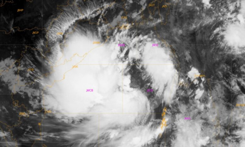
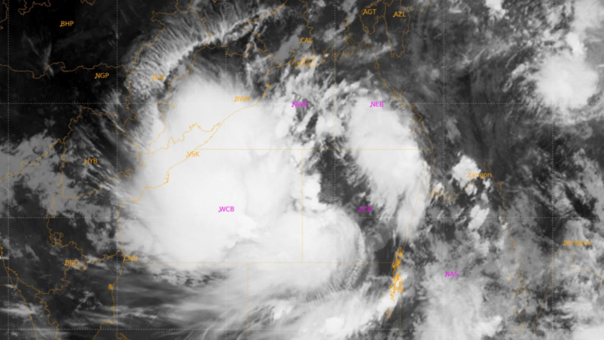
The Deep Depression over Eastcentral Bay of Bengal remained practically stationary during past 6 hours, intensified into Cyclonic Storm ‘Yaas’ (pronounced as ‘Yass’) and lay centred at 0530 hrs IST of today, the 24 th May, 2021 over Eastcentral Bay of Bengal near latitude 16.3°N and longitude 89.7°E, about 600 km north-northwest of Port Blair (Andaman Islands), 540 km south-southeast of Paradip (Odisha), 650 km south-southeast of Balasore (Odisha) and 630 km south-southeast of Digha (West Bengal).

It is very likely to move slowly north-northwestwards, intensify further into a Severe Cyclonic Storm during next 24 hours and into a Very Severe Cyclonic Storm during subsequent 24 hours. It would continue to move north-northwestwards, intensify further and reach Northwest Bay of Bengal near north Odisha and West Bengal coasts by 26th May early morning. It is very likely to cross north Odisha-West Bengal coasts between Paradip and Sagar islands around noon of 26th May as a Very Severe Cyclonic Storm.
Warnings:
(i) Rainfall:
•North Coastal Andhra Pradesh: Light to moderate rainfall at many places with heavy falls at isolated places on 24th May and heavy to very heavy falls at isolated places on 25th & 26th May. •Odisha: Light to moderate rainfall at many places with heavy falls at isolated places over south Coastal Odisha on 24th , heavy to very heavy rainfall in the north coastal districts on 25th, heavy to very heavy rains at a few places with extremely heavy falls in Balasore, Bhadrak, Kendrapara, Mayurbhanj and heavy to very heavy falls at a few places in Jagatsinghpur, Cuttack, Jajpur, Keonjhar on 26th May and heavy to very heavy rainfall at isolated places in north interior Odisha on 27th . Isolated heavy to very heavy rainfall is likely over south coastal districts of Odisha during 25th and 26th May.
• West Bengal & Sikkim: Light to moderate rainfall at most places with heavy to very heavy rainfall over Medinipur, South & north 24 Parganas, Howrah and Hooghly districts on 25th , extremely heavy rainfall at isolated places over Jhargram, Medinipur, North & south 24 Parganas, Howrah, Hooghly, Kolkata and heavy to very heavy rainfall at a few places over Nadia, Bardhaman, Bankura, Purulia, Bhirbhum and heavy falls at isolated places over Murshidabad, Malda and Dakshin Dinajpur Districts on 26th May and heavy to very heavy rain at isolated places in Malda & Darjeeling, Dinajpur, Kalimpong, Jalpaiguri, Sikkim and heavy rain at a few places over Bankura, Purulia, Bardhaman, Bhirbhum & Murshidabad on 27th May.
• Jharkhand: Light to moderate rainfall at most places with heavy to very heavy rainfall at isolated places over Jharkhand and extremely heavy rainfall over southeast Jharkhand on 26 th & 27th May.
• Bihar: Light to moderate rainfall at most places with heavy to very heavy rainfall at isolated places over Bihar on 27th May.
• Assam & Meghalaya: Light to moderate rainfall at most places with heavy to very heavy rainfall at isolated places over Assam, Meghalaya on 26 th & 27th May.
(ii) Wind warning:
Gale winds speed reaching 60–70 kmph gusting to 80 kmph prevailing over Westcentral adjoining Eastcentral Bay of Bengal. It is very likely to increase further becoming Gale wind speed reaching 80 to 90 gusting to 100 kmph over major parts of central Bay of Bengal by 24th evening and would decrease gradually thereafter.
Squally wind speed reaching 40-50 kmph gusting 60 kmph is very likely to prevail over North Bay of Bengal and adjoining westcentral Bay of Bengal along and off north Andhra Pradesh-Odisha–West Bengal–Bangladesh coasts from 24th afternoon. It would increase gradually becoming 50-60 kmph gusting to 70 kmph from 25th evening. It would further increase becoming gale wind speed 60-70 kmph gusting to 80 kmph from 26th early hours over northwest Bay of Bengal and along and off West Bengal & north Odisha and Bangladesh coasts. It would gradually increase further becoming 90-100 gusting to 110 kmph from 26th morning and increase thereafter becoming 155-165 kmph gusting to 180 kmph at the time of landfall.
Squally wind speed reaching 40-50 kmph gusting 60 kmph is very likely to prevail over south Jharkhand from on 26th noon and increase gradually becoming 110-120 kmph gusting to 130 kmph during 26th evening / night.
Squally wind speed reaching 55-65 kmph gusting to 75 kmph likely over north interior districts of Odisha, interior districts of Gangetic West Bengal during 26th evening to 27th morning.
Squally wind speed reaching 50–60 kmph gusting to 70 kmph prevailing over eastcentral Bay of Bengal and adjoining north Andaman Sea during next 12 hours.
(iii) Sea condition
Sea conditions are High to Very High over Westcentral & adjoining eastcentral Bay of Bengal. It is very likely to become Very High to Phenomenal over northern parts of central Bay of Bengal, north Bay of Bengal and along & off north Andhra PradeshOdisha–West Bengal-Bangladesh coasts during 24th – 26th May. (iv) Fishermen Warning
The fishermen are advised not to venture into central Bay of Bengal during 24th–25th May and into north Bay of Bengal and along & off north Andhra Pradesh-Odisha-West Bengal–Bangladesh coasts from 24th – 26th May.
Those who are out in the Deep Sea of north and adjoining central Bay of Bengal are advised to return to the coast.


