Cyclone Akvan Nears Landfall Close to Gopalpur; IMD Warns of 90 kmph Winds, Heavy Rainfall and Coastal Flooding
Outer Rain Bands Reach Land, Landfall Process Expected to Begin Within Two Hours; Odisha and North Andhra Pradesh Under Red Alert

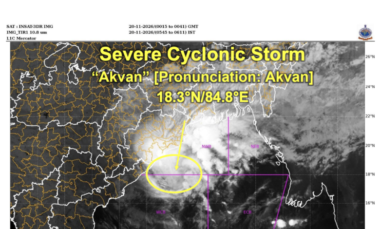
According to the latest IMD bulletin, the cyclone was moving at a speed of approximately 23 kmph during the preceding six hours. At 5:30 am IST, its centre was located over the westcentral Bay of Bengal near the north Andhra Pradesh and south Odisha coasts, at latitude 18.3°N and longitude 84.8°E.
The system was approximately 70 km east of Kalingapatnam in Andhra Pradesh, 110 km south of Gopalpur in Odisha, 170 km east-northeast of Visakhapatnam and 200 km south-southwest of Puri.
The IMD said the cyclone was likely to continue moving north-northwestwards before crossing the north Andhra Pradesh and south Odisha coasts close to Gopalpur by the forenoon of November 20. At the time of landfall, maximum sustained wind speeds were expected to reach 70-80 kmph, with gusts up to 90 kmph.
Landfall Process Expected to Begin Shortly
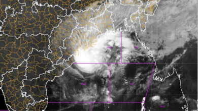
Satellite observations indicated that Cyclone Akvan had already started interacting with the coastline, as its outer rain bands entered land areas. The IMD stated that the actual landfall process was expected to commence within the following two hours from the time of the observation.
The cyclone was being continuously monitored through the Doppler Weather Radar (DWR) at Gopalpur to track its movement, intensity and proximity to the coastline.
The IMD forecast indicated that the system would gradually weaken after crossing the coast. By 11:30 am on November 20, it was expected to remain a cyclonic storm with maximum sustained winds of 70-80 kmph and gusts up to 90 kmph.
By 5:30 pm, the system was forecast to weaken into a deep depression, with wind speeds declining to 50-60 kmph and gusts up to 70 kmph. By 11:30 pm, it was likely to further weaken into a well-marked low-pressure area, with wind speeds falling to 25-35 kmph and gusts up to 45 kmph.
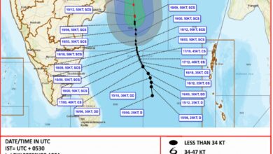
Cyclone Akvan: IMD’s Forecast Track
| Date and Time (IST) | Forecast Position | Wind Speed | System Status |
|---|---|---|---|
| November 20, 5:30 am | 18.3°N, 84.8°E | 80-90 kmph, gusting to 100 kmph | Cyclonic Storm |
| November 20, 11:30 am | 19.5°N, 84.7°E | 70-80 kmph, gusting to 90 kmph | Cyclonic Storm |
| November 20, 5:30 pm | 20.6°N, 84.8°E | 50-60 kmph, gusting to 70 kmph | Deep Depression |
| November 20, 11:30 pm | 21.8°N, 85.0°E | 25-35 kmph, gusting to 45 kmph | Well-Marked Low Pressure Area |
Odisha Faces Extremely Heavy Rainfall Warning
The IMD has forecast widespread rainfall across Odisha, with isolated extremely heavy rainfall of 21 cm or more possible on November 20.
Light to moderate rainfall was expected at most places in Odisha, accompanied by heavy to very heavy rainfall at a few locations. The rainfall intensity was likely to remain significant across coastal and adjoining districts as the cyclone approached and crossed the coast.
North Odisha was expected to receive light to moderate rainfall at many places, with heavy rainfall at isolated locations on November 21.
In north coastal Andhra Pradesh, light to moderate rainfall was forecast at many places, with heavy to very heavy rainfall at isolated locations on November 20.
The weather system was also expected to influence several eastern and central Indian states.
In Gangetic West Bengal, light to moderate rainfall was likely at many places, with heavy to very heavy rainfall at isolated locations on November 20. Isolated heavy rainfall was also forecast for November 21.
South Jharkhand was likely to experience heavy to very heavy rainfall at isolated places on November 20, followed by heavy rainfall on November 21.
East Chhattisgarh was also expected to receive light to moderate rainfall at many places, with heavy rainfall at isolated locations on November 20 and 21. Southeast Bihar was likely to experience similar rainfall activity on November 20.
Flash Flood Risk in Several Districts
The IMD warned of moderate flash flood risk in selected watersheds and neighbourhoods of Odisha and Gangetic West Bengal during the following 24 hours.
In Odisha, the districts identified in the bulletin included Ganjam, Puri, Gajapati and Mayurbhanj.
In Gangetic West Bengal, East Midnapore, Howrah, North 24 Parganas, South 24 Parganas and Nadia were identified as areas requiring caution.
The bulletin accompanying the cyclone forecast also highlighted moderate to high flash flood risks across additional districts in several states, including coastal Andhra Pradesh, Odisha, Gangetic West Bengal and Jharkhand.
The IMD cautioned that surface runoff and inundation could occur in fully saturated soils and low-lying areas due to the expected rainfall during the next 24 hours.
Gale-Force Winds Along Andhra Pradesh and Odisha Coasts
Strong winds associated with Cyclone Akvan were expected to affect coastal areas of Andhra Pradesh and Odisha during the landfall period.
Over the westcentral Bay of Bengal, gale-force winds of 80-90 kmph, gusting up to 100 kmph, were prevailing. These were expected to decrease to 70-80 kmph, with gusts up to 90 kmph, during the morning hours until landfall.
Along and off the north Andhra Pradesh and Yanam coasts, winds of 80-90 kmph, gusting to 100 kmph, were likely to continue until landfall.
The south Odisha coast was expected to experience winds of 70-80 kmph, gusting up to 90 kmph, until the afternoon of November 20.
North Odisha and West Bengal coasts were likely to experience squally winds of 50-60 kmph, with gusts reaching 70 kmph. South Andhra Pradesh was expected to experience winds of 40-50 kmph, gusting to 60 kmph, until the morning.
Wind speeds were forecast to decrease gradually after the cyclone crossed the coastline.
Storm Surge Threat to Low-Lying Coastal Areas
The weather agency issued a storm surge warning for coastal districts of Andhra Pradesh and south Odisha.
A storm surge of approximately 0.5-1.0 metre above the astronomical tide was likely to inundate low-lying areas during landfall.
In Andhra Pradesh, the districts identified as vulnerable included Kakinada, Vizianagaram, Srikakulam and Visakhapatnam.
In Odisha, Ganjam and Puri districts were likely to face the storm surge threat.
The IMD also warned of very high sea conditions, with wave heights of approximately 9-12 metres over the affected marine areas until landfall. Such conditions could make the movement of boats and ships extremely unsafe and significantly reduce visibility.
High to very high sea conditions were expected along the north Andhra Pradesh and Yanam coasts, while the south Odisha coast was also likely to experience high to very rough seas.
Sea conditions were expected to improve gradually after the cyclone crossed the coast.
Rail, Road and Air Services Could Face Disruptions
The IMD warned that Cyclone Akvan could affect transportation and essential infrastructure across the affected coastal districts.
Strong winds and heavy rainfall could damage roads, power lines, railway infrastructure and signalling systems. Localised flooding and waterlogging in low-lying areas could disrupt traffic movement, increase travel time and affect connectivity in major cities.
Railway services could face disruptions due to waterlogging, damage to overhead power lines, signalling equipment and other vulnerable infrastructure.
Airports and heliports in the affected areas could also experience operational disruptions depending on weather conditions.
The IMD advised authorities to judiciously regulate rail, road and air traffic and follow the latest traffic advisories. Commuters were advised to check road conditions and possible traffic restrictions before starting their journeys.
The bulletin also warned of damage to thatched and kutcha houses, rooftops, tin sheets, asbestos structures, communication poles and other vulnerable installations.
Agricultural activities could be affected by strong winds and heavy rainfall. Standing crops, plantations, orchards and horticultural produce were vulnerable to damage. Banana, papaya and drumstick trees, along with coconut plantations, could suffer significant losses.
Fishermen Advised Not to Venture Into the Sea
The IMD reiterated its warning asking fishermen not to venture into the affected areas of the Bay of Bengal.
Fishing activities were to remain suspended over the northern parts of the southwest Bay of Bengal until November 20, and over the westcentral and northwest Bay of Bengal until the morning of November 21.
The agency also advised fisheries departments, fishing harbour authorities, shipping operators and port authorities to monitor subsequent marine warnings and review operational preparedness.
Movement of motorboats and small ships was declared unsafe in the affected marine areas.
Coastal residents, particularly those living in vulnerable huts and temporary structures, were advised to move to safer locations. People in affected areas were urged to remain indoors and avoid staying in structurally vulnerable buildings.
The IMD also recommended that authorities review dam and reservoir conditions and remain alert to possible riverine, urban and coastal flooding.
Authorities Asked to Maintain Vigilance
With Cyclone Akvan approaching the coastline, the IMD emphasised the need for coordinated preparedness among disaster management agencies, state administrations, transport authorities and coastal communities.
The warning covered north coastal Andhra Pradesh, Yanam, south Odisha, north Odisha, Gangetic West Bengal, south Jharkhand and east Chhattisgarh, with varying levels of rainfall and wind-related risks.