
Bay of Bengal System Likely to Become Cyclonic Storm by October 26; IMD Warns of Extremely Heavy Rain in Andhra Pradesh, Odisha
Cyclone Watch | IMD Issues Special Weather Message No. 3 on October 24, 2026

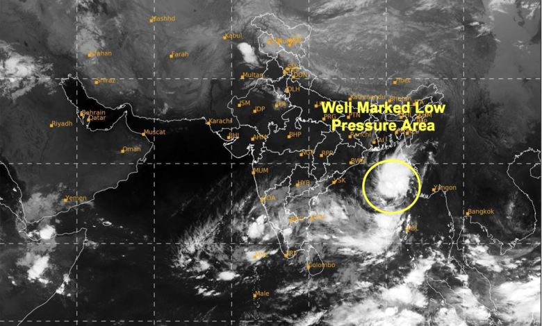
In its Special Message No. 3, issued at 9:45 am IST on October 24, the national weather agency said the system was likely to move west-northwestwards and continue intensifying as it approached the Andhra Pradesh coast. The system is forecast to reach the west-central Bay of Bengal near the Andhra Pradesh coast around the morning of October 28.
The developing weather system could bring heavy to extremely heavy rainfall to Andhra Pradesh and Odisha, while several other eastern and central Indian states are expected to experience heavy rain, strong winds and localised flooding. The IMD has also issued warnings for fishermen, shipping operators, ports and coastal communities as sea conditions are expected to deteriorate over the coming days.
The department has advised the complete suspension of fishing operations in the specified warning areas and urged maritime authorities to monitor subsequent forecasts closely.
Bay of Bengal System: Expected Intensification and Movement
According to the IMD, the low-pressure area identified on October 23 strengthened into a well-marked low-pressure area by 5:30 am IST on October 24.
The department has outlined the following likely progression:
- October 24: The system is expected to intensify into a depression.
- October 25: Further intensification into a deep depression is likely.
- October 26: The system is very likely to become a cyclonic storm over the west-central Bay of Bengal.
- October 26–28: The system is expected to move west-northwestwards and intensify further.
- Morning of October 28: The system is forecast to be over the west-central Bay of Bengal near the Andhra Pradesh coast.
The IMD’s forecast indicates a period of heightened weather risk across parts of eastern and central India between October 24 and 29. However, the bulletin does not provide a confirmed landfall location or a definitive landfall time.
The system’s subsequent movement, intensity and proximity to the coast will determine the distribution and severity of rainfall, wind and coastal impacts. Residents and authorities are advised to follow updated IMD bulletins rather than rely on preliminary projections.
State-Wise Rainfall Forecast: October 24–29
The IMD has issued rainfall warnings for the Andaman Islands, Andhra Pradesh, Odisha, Telangana, West Bengal, Jharkhand, Chhattisgarh, Bihar and Sikkim. Andhra Pradesh and Odisha face the most significant rainfall threat during October 27 and 28.
| State/Region | Forecast and dates |
|---|---|
| Andaman Islands | Light to moderate rain at most places, with heavy rain at isolated locations, October 24–27. |
| Odisha | Heavy to very heavy rain at isolated places on October 27. Heavy to very heavy rain at several places, with extremely heavy rain at isolated locations, on October 28. Heavy to very heavy rain at isolated places on October 29. |
| Andhra Pradesh | Heavy to very heavy rain at several places and extremely heavy rain at isolated locations on October 27–28. |
| Telangana | Heavy to very heavy rain at isolated locations on October 28, followed by heavy rain at isolated places on October 29. |
| Gangetic West Bengal | Heavy rain at isolated locations in coastal districts on October 28–29. |
| Jharkhand | Heavy rain at isolated locations on October 28–29. |
| Chhattisgarh | Heavy to very heavy rain at isolated locations in southern parts on October 28 and northern parts on October 29. |
| Sub-Himalayan West Bengal and Sikkim | Heavy rain at isolated locations on October 29. |
| Bihar | Heavy rain at isolated locations on October 29. |
The rainfall pattern suggests that the weather system’s influence could extend well beyond the immediate coastline. Heavy precipitation may cause localised flooding, waterlogging and transport disruption, particularly in low-lying urban areas and vulnerable coastal locations.
Extremely heavy rainfall at isolated locations does not mean that every district or locality will experience the same intensity. The precise distribution will depend on the system’s movement and subsequent IMD updates.
Wind Speeds to Increase as the System Strengthens
The IMD has warned that wind speeds over the Bay of Bengal are likely to increase significantly between October 24 and 28.
October 24
40–50 km/h, gusting to 60 km/h
East-central and adjoining south-east Bay of Bengal, including waters around the Andaman Islands.
October 25
50–60 km/h, gusting to 70 km/h
East-central, west-central and south-east Bay of Bengal, and waters around the Andaman Islands.
From October 26
70–80 km/h, gusting to 90 km/h
Gale-force winds are likely over the west-central and adjoining east-central Bay of Bengal, with further intensification possible.
Squally weather, with winds of 40–50 km/h and gusts up to 60 km/h, is expected to begin along and off the Andhra Pradesh and Odisha coasts on October 27. Wind speeds are forecast to increase thereafter as the system approaches the region.
Sea Conditions to Deteriorate; Fishermen Warned
Sea conditions are expected to become increasingly dangerous as the system intensifies.
The IMD has forecast rough seas over the east-central and adjoining south-east Bay of Bengal, including waters around the Andaman Islands, through the morning of October 25.
Conditions are expected to become very rough to high over the central and adjoining south-east Bay of Bengal from October 25. High to very high sea conditions are likely over the west-central and adjoining east-central and north-west Bay of Bengal from October 26 to 28.
The Andhra Pradesh and Odisha coasts are also likely to experience rough to very rough seas between October 27 and 28.
The department has advised fishermen not to venture into the following areas:
-
East-central and adjoining south-east Bay of Bengal, including waters around the Andaman Islands, from the evening of October 24 to October 26.
-
West-central and adjoining north-west and south-west Bay of Bengal from October 26 to 28.
-
Waters along and off the Andhra Pradesh and Odisha coasts from October 27 to 28.
Fishing operations in the specified warning areas should be suspended. Fishermen already at sea should follow instructions from maritime and local authorities and the latest IMD advisories.
Coastal Areas Face Risk of Flooding and Wind Damage
The IMD has outlined several potential impacts, particularly over the Andaman Islands and coastal Andhra Pradesh and adjoining Odisha.
Over the Andaman Islands, heavy rainfall between October 24 and 27 could cause localised flooding, waterlogging in low-lying areas, reduced visibility and traffic disruption. Kutcha roads, horticultural activities and standing crops could also be affected.
The risks could become more serious along the Andhra Pradesh and Odisha coasts on October 27 and 28. Strong winds may damage thatched houses and huts, blow off rooftops and dislodge unsecured metal sheets. Trees and branches could be broken or uprooted, while banana and papaya crops may sustain damage.
Heavy rainfall could flood roads, close underpasses and disrupt traffic in urban centres. The IMD has also warned of possible damage to kutcha roads, some pucca roads, embankments, salt pans and coastal crops. Flooding could affect escape routes, making advance planning essential.
These are forecast risks rather than confirmation that such damage will occur. The extent of the impact will depend on the system’s eventual intensity, rainfall distribution and local preparedness.
IMD Advises Coastal Authorities to Prepare
The weather department has urged coastal hutment residents in vulnerable locations to move to safer places and advised people in affected areas to remain indoors when dangerous conditions occur.
People have been advised to avoid vulnerable structures, waterlogged roads and areas prone to recurrent flooding. Motorboat movements may become unsafe as sea conditions deteriorate.
Fisheries departments, fishing harbour authorities, port operators, shipping agencies and offshore installations have been asked to review operational preparedness and monitor subsequent warnings. Maritime authorities should also assess vessel tracking, communications and search-and-rescue arrangements.
Authorities have been advised to regulate offshore and onshore activities according to changing weather conditions. Travellers should follow official traffic advisories and check road conditions before leaving for their destinations.
Cyclone Watch Continues Over the Bay of Bengal
The developing system is being closely monitored as it moves towards the west-central Bay of Bengal. The possibility of a cyclonic storm by October 26 places India’s eastern coastline on alert, with Andhra Pradesh and Odisha facing the most immediate forecast threat.
The IMD has not specified a confirmed landfall location in the supplied bulletin. Its future track and intensity will be crucial in determining which districts experience the heaviest rain and strongest winds.
The department scheduled its next special message for 1 pm IST on October 24, 2026, with further updates expected to clarify the system’s progress.
Residents, fishermen and coastal authorities are advised to follow the latest official forecasts and take precautions in accordance with local warnings.