Depression Over Bay of Bengal to Bring Heavy Rain Across East and Central India

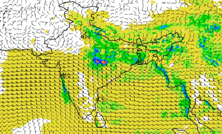
A Depression over the northwest Bay of Bengal and adjoining West Bengal-north Odisha coasts is set to bring heavy to very heavy rainfall across several parts of eastern and central India over the next two days, with the India Meteorological Department (IMD) warning of isolated extremely heavy rainfall in key states.
According to the IMD’s weather bulletin issued at 1:15 pm on August 17, 2026, the depression is likely to move initially north-northwestwards and subsequently northwestwards across Gangetic West Bengal, Jharkhand and Bihar during the next 24 hours. The system is expected to influence rainfall patterns across a large part of eastern and central India.
The IMD has forecast heavy to very heavy rainfall over Gangetic West Bengal, Odisha, Chhattisgarh and Jharkhand during August 17-18, while isolated extremely heavy rainfall is likely over Gangetic West Bengal, Odisha and Chhattisgarh on August 17 and over Jharkhand on August 18.
Extremely Heavy Rainfall Already Recorded
The weather system has already triggered intense rainfall across several states. During the 24-hour period ending at 8:30 am on August 17, extremely heavy rainfall of 21 cm or more was recorded over Odisha.
Very heavy rainfall of 12-20 cm was reported from Uttarakhand, Gangetic West Bengal, Uttar Pradesh, East Madhya Pradesh and Chhattisgarh. Heavy rainfall of 7-11 cm was also recorded in Assam, Himachal Pradesh, Sikkim, Jharkhand, Bihar and West Madhya Pradesh.
Some of the highest rainfall observations included:
| Region | Location | Rainfall |
|---|---|---|
| Odisha | Bhogorai | 22 cm |
| Uttarakhand | Liti | 17 cm |
| Uttar Pradesh | Churk, Sonbhadra | 15 cm |
| Uttar Pradesh | Baheri, Bareilly | 14 cm |
| Gangetic West Bengal | Sagar | 14 cm |
| East Madhya Pradesh | Sihora, Jabalpur | 12 cm |
| Assam | Boko | 10 cm |
| Bihar | Dhalbhumgarh | 9 cm |
| Chhattisgarh | Korba | 9 cm |
| Jharkhand | Manjhari | 8 cm |
East India Under Heavy Rain Threat
Eastern India is expected to remain the main focus of the weather system. Fairly widespread to widespread rainfall is forecast over Gangetic West Bengal and Sub-Himalayan West Bengal and Sikkim through August 23. Jharkhand is expected to receive widespread rainfall on August 17-19 and again on August 23, while Bihar is likely to experience widespread rainfall during August 17-19. Odisha is likely to see widespread rainfall from August 17-20.
The IMD has warned of isolated extremely heavy rainfall over Odisha and Gangetic West Bengal on August 17 and over Jharkhand on August 18. Very heavy rainfall is also possible over Jharkhand on August 17 and Bihar and Odisha on August 18.
Thunderstorms, lightning and gusty winds are another concern. On August 17, Gangetic West Bengal, Jharkhand and Odisha may experience winds of 40-50 kmph, gusting to 60 kmph. Similar gusty conditions are expected in parts of the region over the following days. Bihar is also likely to witness moderate to severe lightning activity on August 17.
Central India to Receive Heavy Rain
The rainfall belt will extend into central India. West Madhya Pradesh is likely to experience fairly widespread to widespread rainfall from August 17-21, while East Madhya Pradesh is expected to receive widespread rainfall through August 23.
Vidarbha is likely to see widespread rainfall on August 17-18 and again from August 21-23. Chhattisgarh is forecast to receive widespread rainfall during August 17-19 and again from August 22-23.
The IMD has warned of isolated extremely heavy rainfall over Chhattisgarh on August 17, with very heavy rainfall possible over East Madhya Pradesh during August 17-19 and Chhattisgarh on August 18.
Rain Forecast Across Northwest India
The weather system and associated atmospheric conditions will also influence northwest India. Fairly widespread to widespread rainfall is forecast over Jammu and Kashmir, Ladakh, Gilgit-Baltistan and Muzaffarabad from August 17-22, while Himachal Pradesh and Uttarakhand are expected to receive widespread rainfall through August 23.
Punjab is likely to see widespread rainfall on August 18, while Haryana, Chandigarh and Delhi may receive widespread rainfall on August 18 and again on August 21-22. West Uttar Pradesh is expected to see rainfall on August 17 and during August 21-22, while East Uttar Pradesh may experience widespread rainfall through August 23.
Isolated heavy rainfall is possible over several areas, including Uttarakhand, Punjab, Haryana, Chandigarh, Delhi and Uttar Pradesh. The IMD has also forecast isolated very heavy rainfall over Uttarakhand on August 17, Himachal Pradesh and West Uttar Pradesh on August 18, and East Uttar Pradesh on August 17 and during August 20-21.
Delhi-NCR Forecast
Delhi is expected to remain generally cloudy during the next few days. On August 17, partly cloudy conditions are likely, with a spell of very light to light rain possible at a few places during the afternoon and evening. The maximum temperature is expected to remain between 34°C and 36°C.
On August 18, Delhi may witness generally cloudy skies and light rain at a few places, with temperatures ranging from 32°C to 34°C.
The weather is expected to become wetter on August 19 and 20, with one or two spells of light rain at many places and moderate rain at isolated locations during the morning to noon. Another spell of very light to light rain is possible during the evening to night. Maximum temperatures are forecast at 31-33°C on August 19 and 33-35°C on August 20.
Rainfall Outlook for Other Regions
The IMD has forecast widespread rainfall over Konkan and Goa from August 17-23, while Gujarat Region is likely to receive widespread rainfall on August 17. Isolated heavy rainfall is possible over Gujarat on August 17, accompanied by thunderstorms, lightning and gusty winds reaching 40-50 kmph and gusting to 60 kmph.
Northeast India will also remain active, with widespread rainfall forecast over Arunachal Pradesh during August 17-21 and over Assam and Meghalaya and Nagaland, Manipur, Mizoram and Tripura during August 17-23. Heavy rainfall is possible across several parts of the region during this period.
In southern India, widespread rainfall is expected over Kerala and Mahe and Lakshadweep from August 17-20, while Coastal Karnataka may experience widespread rainfall through August 23. Heavy rainfall is possible over Kerala on August 18 and Tamil Nadu, Puducherry and Karaikal during August 18-19.
Squally Winds, Rough Seas and Fishermen Warning
The IMD has issued a specific warning for coastal areas. Squally winds of 45-55 kmph, gusting to 65 kmph, are likely over the north Bay of Bengal and along and off the West Bengal-Bangladesh, Odisha and north Andhra Pradesh coasts until August 18. Conditions are expected to gradually improve thereafter.
Sea conditions are likely to remain rough to very rough over the north Bay of Bengal and along and off the West Bengal-Bangladesh, Odisha and north Andhra Pradesh coasts until August 18.
The IMD has advised fishermen not to venture into these waters until August 18.
Flash Flood Risk
The IMD has identified a low to moderate flash flood risk over several watersheds and adjoining areas during the 24 hours ending at 11:30 am on August 18.
The areas include districts in Chhattisgarh, East Madhya Pradesh, Odisha, Gangetic West Bengal and Jharkhand. In these areas, surface runoff, waterlogging and inundation may occur, particularly where soils are already saturated and in low-lying locations.
Possible Impact and Advisory
The IMD has warned that intense rainfall and strong winds could lead to waterlogging, localised flooding, landslides, mudslides and reduced visibility. Heavy rain and squally winds may also disrupt road and rail traffic. Vulnerable structures, roads, crops and plantations could suffer damage, while loose objects may be blown away.
People in affected areas have been advised to monitor weather updates and move to safer locations if conditions deteriorate. The IMD has specifically advised people not to take shelter under trees during lightning activity and to stay away from water bodies and objects that conduct electricity. Tourism, recreational activities and onshore and offshore operations may also need to be regulated.
With the depression moving inland, eastern and central India are likely to remain the primary zones of concern through August 18, while its broader circulation and associated weather systems will continue to influence rainfall across several other parts of the country in the days ahead.