IMD Weather Forecast: Heavy Rain to Continue Across India From August 17; Extremely Heavy Rain Alert for Odisha and West Bengal

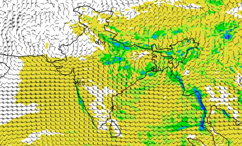
The India Meteorological Department (IMD) has forecast another spell of widespread monsoon rainfall across several parts of India from August 17 onwards, with particularly intense weather expected over Odisha, Gangetic West Bengal, the Western Himalayan region, Uttar Pradesh, northeast India and parts of central India. The forecast comes as a low-pressure area has formed over the northwest Bay of Bengal and adjoining West Bengal-North Odisha coasts, with the system likely to move nearly northwestwards and become more marked during the next 24 hours.
The IMD has warned of isolated extremely heavy rainfall over Odisha on August 17 and over Gangetic West Bengal on August 17. Heavy to very heavy rainfall is also expected across Odisha, West Bengal, Jharkhand and neighbouring areas during the initial part of the forecast period.
Low-pressure system to drive intense rainfall
The low-pressure area was located over the northwest Bay of Bengal and adjoining coastal areas of West Bengal and North Odisha on August 16. According to the IMD, it is likely to move nearly northwestwards and become more marked during the following 24 hours.
The monsoon trough is also playing an important role in the weather pattern. Its western end is positioned north of its normal location, while the eastern end remains south of normal. An upper-air cyclonic circulation is present over southeast Uttar Pradesh, while another circulation lies over northwest Uttar Pradesh. Additional cyclonic circulation is present over Gujarat and Jammu Division and adjoining areas.
Key rainfall forecast from August 17 onwards
| Date | Major areas of concern | Expected weather |
|---|---|---|
| August 17 | Odisha, Gangetic West Bengal, Jharkhand, Bihar, Western Himalayas, Northeast | Extremely heavy rain possible over Odisha and Gangetic West Bengal; heavy to very heavy rain in several areas |
| August 18 | Gangetic West Bengal, Jharkhand, Bihar, Western Himalayas, Haryana, Punjab, Delhi-NCR | Heavy rainfall continues in several regions |
| August 19 | Bihar, Jharkhand, East UP, East Rajasthan, Western Himalayas, Central India | Heavy rain in isolated areas; Western Himalayan region remains active |
| August 20 | Bihar, East Rajasthan, West Madhya Pradesh, Northeast | Heavy rainfall continues in selected areas |
| August 21 | East Rajasthan, West Madhya Pradesh, East Madhya Pradesh, Northeast | Rainfall activity persists |
| August 22 | Western Himalayas, East Madhya Pradesh, Northeast | Continued rainfall, with isolated heavy rain in some areas |
Odisha and West Bengal face the biggest threat
Odisha and Gangetic West Bengal are likely to witness the most intense rainfall during the immediate forecast period. The IMD has specifically forecast isolated extremely heavy rainfall over Odisha on August 17 and Gangetic West Bengal on August 17.
Odisha is expected to receive fairly widespread to widespread rainfall through August 20. Heavy rainfall is forecast on August 16-17, while the possibility of extremely heavy rainfall on August 17 raises the risk of waterlogging, flooding and disruption to road and rail traffic.
Gangetic West Bengal is expected to receive widespread rainfall through August 22, with heavy rain on August 17-18 and extremely heavy rain possible on August 17. Sub-Himalayan West Bengal and Sikkim are also expected to receive heavy rainfall around August 17-18.
Jharkhand and Bihar will also remain under a prolonged wet-weather spell. Fairly widespread to widespread rainfall is forecast over Bihar and Jharkhand during August 17-19, while heavy rainfall is possible over Bihar from August 17-20. Jharkhand could see heavy rainfall during August 17-18.
Western Himalayas to remain wet
The Western Himalayan region is another major area of concern from August 17 onwards. The IMD has forecast fairly widespread to widespread rainfall over Jammu & Kashmir, Ladakh, Himachal Pradesh and Uttarakhand through August 22.
Isolated very heavy rainfall is possible over Jammu & Kashmir and adjoining areas during August 17-19, while Himachal Pradesh may experience very heavy rain on August 17-18. Uttarakhand and West Uttar Pradesh are also expected to experience heavy rainfall during the period.
The prolonged rainfall could increase the risk of landslides, mudslides, landslips, waterlogging and disruption of transport, particularly in vulnerable hilly and low-lying areas. The IMD has specifically advised caution in vulnerable regions.
Delhi-NCR: Rain continues, temperatures remain near normal
For Delhi-NCR, the IMD expects generally cloudy conditions and light rainfall spells from August 17 onwards.
On August 17, one or two spells of very light to light rain are likely from early morning to afternoon, followed by another spell towards evening and night. The maximum temperature is expected to remain around 33-35°C, while the minimum may stay between 24-26°C.
On August 18, similar cloudy conditions with light rain spells are expected, with temperatures around 33-35°C during the day and 23-25°C at night. On August 19, the maximum temperature may fall slightly to 32-34°C, with the minimum around 23-25°C.
Delhi-NCR forecast
| Date | Sky/Rain | Maximum Temperature | Minimum Temperature |
|---|---|---|---|
| Aug 17 | Cloudy; light rain spells | 33-35°C | 24-26°C |
| Aug 18 | Cloudy; light rain spells | 33-35°C | 23-25°C |
| Aug 19 | Cloudy; possibility of light rain | 32-34°C | 23-25°C |
Uttar Pradesh and Rajasthan also remain active
The monsoon pattern will keep Uttar Pradesh wet during the coming days. West Uttar Pradesh is likely to receive widespread rainfall around August 17, while East Uttar Pradesh is expected to experience widespread rainfall through August 22. Heavy rainfall is forecast over West Uttar Pradesh on August 18 and East Uttar Pradesh on August 19.
East Rajasthan is expected to see rainfall activity increase around August 20-21, with isolated heavy rainfall possible during August 19-21.
Central India to see another round of heavy rain
Central India will also remain under the influence of the prevailing weather systems. Chhattisgarh and East Madhya Pradesh are expected to receive fairly widespread to widespread rainfall through August 22. West Madhya Pradesh may see another active spell during August 19-21.
The IMD has forecast very heavy rainfall over West Madhya Pradesh on August 20-21, while East Madhya Pradesh may experience heavy rainfall during August 18-19 and again on August 21-22. Chhattisgarh could receive heavy rainfall on August 18, with very heavy rain possible during August 16-17.
Northeast India to remain wet through August 22
Northeast India is also expected to remain under a prolonged rainfall spell. Arunachal Pradesh is likely to receive fairly widespread to widespread rainfall through August 21, while Assam, Meghalaya and the northeastern states of Nagaland, Manipur, Mizoram and Tripura could experience widespread rainfall through August 22.
Isolated very heavy rainfall is possible over Arunachal Pradesh on August 17-18. Heavy rainfall is also expected over Assam and Meghalaya and the other northeastern states during the forecast period.
Western and southern India
Konkan and Goa are likely to receive fairly widespread to widespread rainfall through August 22. Madhya Maharashtra and parts of Marathwada may also experience isolated to scattered rainfall. Gujarat and Saurashtra-Kutch are expected to see intermittent rainfall activity during August 17-22.
In southern India, Coastal Karnataka is likely to remain broadly wet through August 22. Kerala and Mahe are expected to receive widespread rainfall through August 20, followed by rainfall activity again around August 21-22. Tamil Nadu, Puducherry and Karaikal could receive heavy rainfall on August 18-19.
Flash-flood risk in Odisha and Gangetic West Bengal
The IMD has identified a low to moderate flash-flood risk for some watersheds and neighbourhoods in Odisha and Gangetic West Bengal through the morning of August 17.
In Odisha, districts including Angul, Bargarh, Cuttack, Deogarh, Jagatsinghpur, Jajpur, Jharsuguda, Kendrapara, Keonjhar, Mayurbhanj, Puri and Sambalpur are included in the area of concern. In Gangetic West Bengal, East Midnapore, Howrah, Jhargram, North 24 Parganas, South 24 Parganas and West Midnapore face a similar risk.
Transport and public safety concerns
The IMD has warned that extremely heavy and heavy rainfall may affect road and rail traffic, particularly where intense rain combines with waterlogging or squally winds. Localised flooding, landslides and reduced visibility could disrupt movement, while strong winds may damage vulnerable structures, uproot trees and affect agricultural crops.
Authorities and residents in vulnerable areas have been advised to monitor weather updates and be prepared to move to safer locations if conditions deteriorate. The IMD has also advised people to avoid taking shelter under trees during thunderstorms and to regulate tourism and recreational activities in areas affected by severe weather.
Overall, August 17 onwards is likely to remain a period of active monsoon weather across large parts of India. Odisha and Gangetic West Bengal face the immediate threat of extremely heavy rain, while the Western Himalayas, Uttar Pradesh, Bihar, Jharkhand, central India and the Northeast are expected to remain wet over several days. The IMD forecast indicates that rainfall activity will continue across different regions through August 22, although the intensity and location of the heaviest rain will shift from day to day.