
Chennai Braces for More Rain as Depression Hovers 40 km Offshore
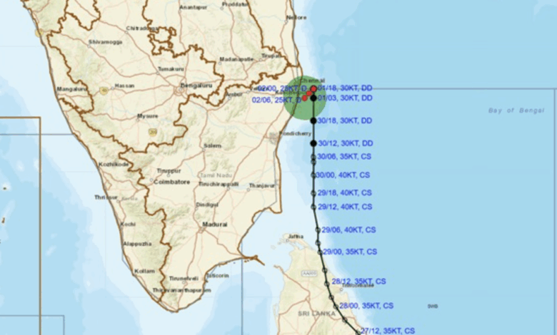
The deep depression over the southwest Bay of Bengal, the remnant of Cyclonic Storm Ditwah, has weakened into a depression and now lies just 40 km east-southeast of Chennai as of 5:30 AM today. The India Meteorological Department (IMD) said the system, centred near latitude 12.9°N and longitude 80.5°E, is only 25 km from the north Tamil Nadu–Puducherry coast – the closest it has come to land.
Moving slowly southwestwards at 3 km/h, the depression is likely to maintain its intensity for the next 12 hours before weakening into a well-marked low-pressure area while approaching the coast. Doppler radars at Chennai and Sriharikota are continuously tracking the system.
Overnight Deluge Breaks Records in North Chennai
Between 5:30 AM on 1 December and 5:30 AM today, Chennai recorded exceptionally heavy rainfall, with several northern zones receiving more than 200 mm in 24 hours:
- Ennore (Zone 1): 264.3 mm
- Parrys Corner (Zone 5): 265.2 mm
- Basin Bridge (Zone 5): 207.6 mm
- New Manali Town (Zone 2): 206.6 mm
- Manali (Zones 2): 186.2 mm
Other areas such as Tondiarpet, Kasimedu, Ice House, and Nungambakkam also recorded very heavy to extremely heavy rain ranging from 162 mm to 231 mm.
Forecast for Next 24 Hours
Heavy to very heavy rain is likely to continue at most places over Chennai, Tiruvallur, Kancheepuram, Chengalpattu, and Villupuram districts, with isolated extremely heavy falls (>204 mm) possible until morning. Fishermen are advised not to venture into the sea along north Tamil Nadu, Puducherry, and south Andhra Pradesh coasts.
Civic authorities have opened additional relief centres, deployed extra pumps in low-lying areas, and kept schools and colleges shut in Chennai and neighbouring districts for the second consecutive day. Traffic movement remains severely affected in north and central Chennai due to waterlogging.
The IMD has warned that the slow-moving system may cause prolonged rainfall activity even after it weakens, keeping Chennai and adjoining areas on high alert through Tuesday night.