
GSLV-F16 Successfully Launches NISAR: A Landmark ISRO-NASA Earth Observation Mission
India’s GSLV-F16 rocket has successfully lifted off, carrying the groundbreaking NISAR satellite into orbit, marking a major milestone in Indo-U.S. space collaboration. With a flawless launch and all mission stages executing precisely—including the critical cryogenic ignition—the NISAR satellite was successfully deployed into its designated orbit.
NISAR: A Pioneering Joint Mission
The NASA-ISRO Synthetic Aperture Radar (NISAR) mission is the first Earth observation mission of its kind, jointly developed by the Indian Space Research Organisation (ISRO) and the U.S. space agency NASA. The satellite carries a state-of-the-art dual-frequency Synthetic Aperture Radar (SAR) system operating in both L-band and S-band frequencies.
NISAR employs a novel SweepSAR technology, which enables it to capture high-resolution images over a wide swath, imaging Earth’s land and ice-covered surfaces—including islands, sea ice, and selected ocean areas—every 12 days.
Mission Goals and Scientific Objectives
NISAR is designed to monitor and study key Earth systems with unprecedented detail. Its objectives include:
-
Mapping and tracking changes in woody biomass and forest cover
-
Monitoring agricultural crop extent and productivity
-
Measuring wetland areas and their seasonal changes
-
Observing ice sheet movements in Greenland and Antarctica, as well as mountain glaciers and sea ice dynamics
-
Detecting land surface deformation from seismic activity, volcanic eruptions, landslides, and changes in groundwater or hydrocarbon reservoirs
Satellite Configuration and International Collaboration
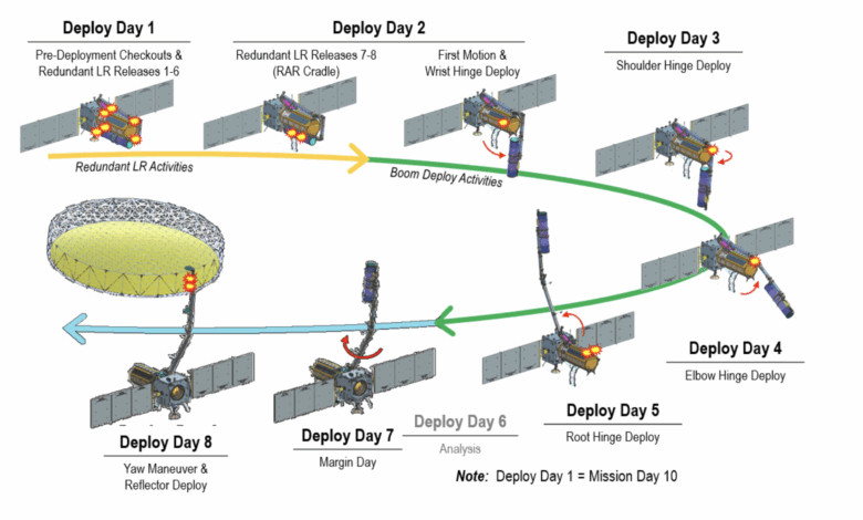
Built on ISRO’s I-3K satellite platform, NISAR hosts two major payloads: an S-band SAR developed by ISRO and an L-band SAR supplied by NASA. ISRO has also contributed to the satellite structure, data handling, high-speed downlink system, and the launch vehicle, while NASA provided components including the 12-meter radar reflector, a solid-state recorder, GPS receiver, and the 9-meter deployment boom.
Operational responsibilities are shared: ISRO will manage spacecraft operations and command, while NASA will oversee orbital maneuvers and radar operations. Ground stations from both agencies will collaborate in receiving and processing the data, which will be made available to the global scientific community.
A Step Forward in Earth System Science
NISAR’s ability to gather fully polarimetric and interferometric radar data from a single platform marks a transformative step in Earth observation capabilities. By delivering high-quality data on dynamic Earth processes, the mission is expected to provide crucial insights into environmental changes, natural disasters, and climate science, benefiting researchers, policy-makers, and communities worldwide.