IMD Issues Cyclone Alert: Low Pressure Area in Bay of Bengal Intensifying

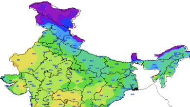
The India Meteorological Department (IMD) reports a well-marked low-pressure area in the Southeast Bay of Bengal, set to evolve into Cyclone Michaung by December 2nd. A wet spell with thunderstorm activity is forecasted for Madhya Pradesh and Maharashtra over the next three days. Additionally, a fresh Western Disturbance is expected to impact the Western Himalayan region and adjoining plains in the next two days.
Current Weather Highlights:
- A Cyclonic Circulation is noted over north Sri Lanka, while a fresh Western Disturbance forms a trough in mid-tropospheric levels.
- A trough in easterlies extends from North Kerala to North Madhya Maharashtra in lower tropospheric levels, leading to interactions between middle-level westerlies and lower-level easterlies over central India.
Upcoming Weather Predictions (Next 5 Days):
- Scattered to fairly widespread rainfall/snowfall is anticipated over Jammu-Kashmir, Ladakh, Gilgit-Baltistan, Muzaffarabad, and Himachal Pradesh, with possible heavy precipitation in specific areas.
- Madhya Pradesh, Vidarbha, Tamil Nadu, Puducherry, Karaikal, Kerala, Mahe, Andhra Pradesh, and Yanam are expected to experience rainfall with thunderstorm activity at various intensities.
- Fishermen are advised to exercise caution in the Andaman Sea and Bay of Bengal, with wind warnings issued for specific regions.
Cyclone Alert and Warnings:
- The well-marked low-pressure area is projected to intensify, with potential impacts on Nicobar Islands, Coastal Tamil Nadu, Puducherry, Coastal Andhra Pradesh, and adjoining regions.
- Wind warnings are issued for Andaman Sea, Southeast Bay of Bengal, Southwest Bay of Bengal, and Central Bay of Bengal.
- Fishermen are cautioned against venturing into specific sea areas during defined periods.
For detailed forecasts and updates, refer to the official IMD website: IMD Forecast Bulletin and Cyclone Information.


