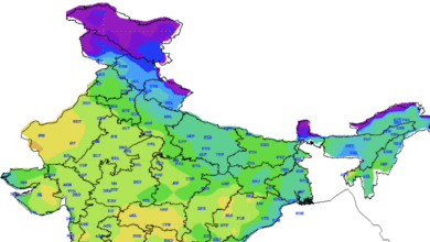
Western Disturbance giving wet spell in North-West India, Temperatures to rise from 15th March onwards
Realised Weather (from 0830 hours IST of yesterday to 0830 hours IST of today)
- As predicted, Light to moderate Rainfall/Thundershowers observed: at most places over Jammu, Kashmir & Ladakh, Himachal Pradesh, Uttarakhand, East Uttar Pradesh and Jharkhand; at many places over Bihar, Chhattisgarh and Sub-Himalayan West Bengal & Sikkim; at a few places over Punjab, Haryana, Chandigarh & Delhi, West Uttar Pradesh and East Madhya Pradesh and at isolated places over Vidarbha, Telangana, Odisha, Gangetic West Bengal and Assam & Meghalaya.
- Rainfall recorded at 0830 hours IST of today (3 cm or more): Hazaribag-10; Nainital- 8; Naina Devi and Latehar- 7 each; Varanasi and Daltonganj-5 each; Dharmsala, Gaya and Ambikapur- 4 each; Baderwah, Shimla, Najibabad, Bahraich, Churk, Malanjkhand and Seoni- 3 each.
- Heavy rainfall observed at isolated places over Himachal Pradesh, Uttarakhand and Jharkhand.
- Hailstorm observed at many places over East Uttar Pradesh (Hardoi, Lucknow, Bahraich, Sultanpur) and at isolated places over West Uttar Pradesh (Meerut, Bulandshahar), Himachal Pradesh (Shimla, Mandi, Sirmaur), Jammu Division, Uttarakhand (Nainital, Mukteshwar, Dehradun), Punjab (Patiala), Haryana (Ambala), Jharkhand (Hazaribagh) and Chhattisgarh (Masamodi).
Weather System & Forecast
♦ Yesterday’s ‘Western Disturbance’ as a cyclonic circulation over north Pakistan & neighbourhood now lies over Punjab & neighbourhood extending upto upper tropospheric levels. The induced cyclonic circulation now lies over northeast Rajasthan & neighbourhood in lower levels. Though the moisture feed from the Arabian Sea has been cut off with the eastward movement of the system, low level southeasterly winds from the Bay of Bengal are feeding moisture towards eastern India, where the upper level features are also conducive for development of thunderstorms and hailstorms. However, this feature is very likely to shift further eastwards by tomorrow leading to a drastic reduction in the thunderstorm activity over Bihar, Jharkhand, north Chhattisgarh and West Bengal from 15th March and increase over the northeastern states. Significant weather expected is as follows:
- Light to moderate scattered to fairly widespread rainfall/snowfall is very likely over Jammu, Kashmir, Ladakh & Gilgit and Baltistan, Himachal Pradesh, Uttarakhand with hailstorm over Uttarakhand and thunderstorm over Himachal Pradesh during next 24 hours.
- Light to moderate fairly widespread rainfall very likely over Punjab and East Uttar Pradesh and scattered rainfall over Haryana, Chandigarh, Delhi and West Uttar Pradesh during next 24 hours and decrease thereafter. Hailstorm with gusty winds is also likely over the same region during next 24 hours.
- Moderate scattered to fairly widespread rainfall with isolated thunderstorm/hailstorm, lightning/gusty wind winds (speed reaching 40-50 kmph occasionally) over north Chhattisgarh, Bihar, Jharkhand and West Bengal & Sikkim during next 24 hours. Isolated heavy falls are also likely over Jharkhand and Bihar during the same period.


