
Heavy Rain Forecast for Central, North and East India; East MP Faces Very Heavy Rain on August 21

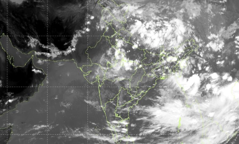
The India Meteorological Department (IMD) has warned of continued heavy rainfall across several parts of India, with the weather system over northeast Madhya Pradesh expected to remain a major influence on rainfall activity over Central India and adjoining regions. The latest forecast, issued on August 20, indicates that East Madhya Pradesh is likely to receive isolated very heavy rainfall on August 21, while several other states are expected to experience heavy rain, thunderstorms and gusty winds.
The IMD said the well-marked low-pressure area over northeast Madhya Pradesh and adjoining areas, which was earlier extending into southeast Uttar Pradesh and northwest Chhattisgarh, was centred over northeast Madhya Pradesh and neighbourhood on August 20. The system is contributing to widespread rainfall activity over Central India.
For August 21, the IMD has forecast isolated very heavy rainfall over East Madhya Pradesh, while heavy rainfall is likely at isolated places over West Madhya Pradesh, Chhattisgarh, West Uttar Pradesh, Odisha and several other regions.
The western end of the monsoon trough is currently north of its normal position, while its eastern end remains close to its normal position. A fresh Western Disturbance is also present as a cyclonic circulation over north Pakistan and adjoining Jammu division in the middle tropospheric levels. In addition, cyclonic circulations are present over northeast Assam and northwest Uttar Pradesh, further influencing weather conditions across northern and eastern India.
East Madhya Pradesh Under Watch
East Madhya Pradesh remains one of the key areas of concern on August 21. The IMD has forecast very heavy rainfall at isolated places in the region, following significant rainfall already recorded across the area.
During the 24-hour period ending at 8:30 am on August 20, Rewa in East Madhya Pradesh recorded 19 cm of rainfall, the highest reported rainfall among the listed meteorological subdivisions. Chhattisgarh’s Mungeli recorded 14 cm, while Aliganj in Uttar Pradesh’s Etah district received 13 cm.
The IMD has also warned of a low to moderate flash flood risk in several districts of East Madhya Pradesh until 11:30 am on August 21. These include Tikamgarh, Satna, Rewa, Chhatarpur, Damoh, Jabalpur, Katni, Umaria, Panna, Sidhi, Shahdol, Dindori and Anuppur.
Surface runoff and inundation may occur in fully saturated soils and low-lying areas in these districts, particularly where additional rainfall is received.
West Uttar Pradesh, Odisha Also Face Heavy Rain
West Uttar Pradesh is likely to receive isolated heavy rainfall on August 21. The region has already experienced significant rainfall, with Aliganj in Etah recording 13 cm during the past 24-hour period.
Odisha is another area expected to see substantial rainfall activity. The IMD has forecast heavy rainfall on August 21 and 22, with the possibility of isolated very heavy rainfall on August 23. Rainfall activity is expected to continue across the state through August 26.
Sub-Himalayan West Bengal and Sikkim are also likely to receive heavy rainfall through August 22, while Bihar is expected to experience heavy rainfall from August 22 to 25. Jharkhand may receive isolated heavy rainfall on August 23.
Thunderstorms, lightning and gusty winds are also expected across parts of Bihar, Gangetic West Bengal, Jharkhand and Odisha during the period.
Rainfall Activity in North India
The western Himalayan region will continue to experience rainfall. Fairly widespread to widespread rainfall is forecast over Jammu and Kashmir, Ladakh and adjoining areas through August 23, while Himachal Pradesh is expected to receive similar conditions through August 22.
Uttarakhand is likely to experience fairly widespread to widespread rainfall through August 26, accompanied by isolated thunderstorms and lightning.
The IMD has also forecast isolated heavy rainfall over Jammu and Kashmir, Ladakh and Himachal Pradesh through August 22. West Uttar Pradesh is expected to see heavy rainfall on August 21.
A low to moderate flash flood risk has also been identified for several districts of Jammu and Kashmir and Ladakh, including Kupwara, Bandipora, Baramulla, Poonch, Kulgam, Reasi, Ramban, Anantnag, Doda, Kishtwar, Kathua and Udhampur. In Himachal Pradesh, Chamba, Kangra, Kullu, Shimla and Sirmaur are among the districts under flash-flood risk.
Delhi-NCR to Remain Generally Cloudy
Delhi is expected to remain generally cloudy on August 21, with one or two spells of very light to light rain at many places from early morning to noon. Another spell of light rain is possible towards the night.
The maximum temperature is likely to remain between 33°C and 35°C, while the minimum temperature is expected to be between 24°C and 26°C. Winds are likely to reach around 18 kmph during the morning before weakening during the afternoon.
On August 22, Delhi could receive light rain at many places, with moderate rain possible at isolated locations. Temperatures are expected to remain between 32°C and 34°C during the day and 24°C and 26°C at night.
Rain Continues Across Other Regions
Fairly widespread to widespread rainfall is forecast over Konkan and Goa through August 26. Coastal Karnataka is also expected to experience widespread rainfall during the same period.
In the Northeast, Arunachal Pradesh, Assam and Meghalaya are likely to receive widespread rainfall through August 22, while Nagaland, Manipur, Mizoram and Tripura could experience rainfall through August 26. Isolated heavy rainfall is expected across parts of the Northeast.
In southern India, scattered rainfall is forecast over Andhra Pradesh, Telangana, Karnataka, Tamil Nadu and adjoining areas. Kerala and Mahe are likely to receive heavy rainfall on August 23 and 24.
Fishermen Advised to Exercise Caution
The IMD has issued a fishermen warning for several sea areas through August 25, including parts of the Arabian Sea, Bay of Bengal, Gulf of Mannar, southwest Bay of Bengal, Andaman Sea and adjoining waters.
A swell surge of 1.1 to 2.1 metres has also been warned along the Kerala and south Tamil Nadu coasts.
The weather department has advised people in vulnerable areas to monitor weather updates and move to safer locations if conditions deteriorate. It has also cautioned against taking shelter under trees during thunderstorms and urged people to avoid water bodies during lightning activity.
The IMD has advised farmers in affected regions to maintain effective drainage, remove excess water from fields and postpone agricultural operations such as fertiliser and pesticide application where fields remain waterlogged.
With heavy rainfall expected to continue across Central, North and East India, authorities and residents in vulnerable districts have been advised to remain alert to the possibility of waterlogging, localised flooding, landslides and disruption to road and rail traffic.