Weather Report: Low-Pressure Areas Form in Arabian Sea and Bay of Bengal, Heavy Rainfall Recorded

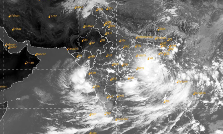
In a significant meteorological update, the presence of a Low-Pressure Area has been detected over the Eastcentral Arabian Sea, located just off the south Konkan-Goa coasts. Simultaneously, another Low-Pressure Area has formed over the Northeast and adjoining Eastcentral Bay of Bengal. These weather phenomena bear the potential to influence regional weather patterns significantly.
Southwest Monsoon Withdrawal:
- Conditions are becoming favorable for the gradual withdrawal of the Southwest Monsoon from certain regions of Northwest and adjoining Westcentral India within the next 2-3 days.
- The current withdrawal line of the Southwest Monsoon extends through 28.3°N/72.0°E, encompassing Nokhra, Jodhpur, Barmer, and 25.7°N/70.3°E.
Key Weather Features:
- Eastcentral Arabian Sea:
- A Low-Pressure Area exists over the Eastcentral Arabian Sea, situated off the south Konkan-Goa coasts.
- This system is anticipated to intensify into a Well-Marked Low-Pressure Area within the next 24 hours.
- It is expected to persist over the same region for the subsequent 24 hours.
- Bay of Bengal:
- Another Low-Pressure Area has developed over Northeast and adjoining Eastcentral Bay of Bengal.
- This weather system is forecasted to evolve into a Well-Marked Low-Pressure Area and move northwestwards towards the north Odisha and adjoining West Bengal coasts over the next 48 hours.
- Additional Weather Features:
- A Shear Zone is identified at approximately 15°N in the lower and middle tropospheric levels.
- A cyclonic circulation has been detected over the Southwest Bay of Bengal, positioned off the Tamil Nadu coast in the middle tropospheric levels.
Weather Forecast and Warnings:
East India:
- Light to moderate fairly widespread to widespread rainfall, thunderstorms, and lightning are expected over Andaman & Nicobar Islands and Gangetic West Bengal from September 29th to October 1st.
- Odisha is likely to experience these weather conditions on September 29th and October 3rd.
- Jharkhand will observe these conditions from September 30th to October 3rd.
- Bihar is expected to have similar weather from October 1st to October 3rd.
- Sub-Himalayan West Bengal & Sikkim can anticipate these conditions on October 2nd and 3rd.
Isolated heavy rainfall is predicted over various regions during the specified periods.
South India:
- Light to moderate fairly widespread to widespread rainfall, including isolated heavy rainfall, is likely over ghat areas of Tamil Nadu, Andhra Pradesh, Telangana, Karnataka, Kerala, and Mahe from September 29th to October 1st.
West India:
- Light to moderate fairly widespread to widespread rainfall, thunderstorms, and lightning are expected over Konkan-Goa and Madhya Maharashtra on September 29th to October 1st.
- Isolated very heavy rainfall is anticipated over south Konkan-Goa on September 29th and 30th.
Central India:
- Light to moderate fairly widespread to widespread rainfall, thunderstorms, and lightning with isolated heavy rainfall are likely over Chhattisgarh from September 29th to October 2nd.
Northeast India:
- Light to moderate fairly widespread to widespread rainfall, thunderstorms, and lightning with isolated heavy rainfall are expected over Assam & Meghalaya, Nagaland, Manipur, Mizoram & Tripura on various dates in the forecast period.
- Arunachal Pradesh may experience these conditions on October 3rd.
These weather conditions may lead to localized flooding, occasional visibility reduction, traffic disruptions, and other minor impacts. It is advised to stay informed and take necessary precautions.
For more detailed information, please refer to the official forecast bulletin.


