Extended Weather Outlook: India Braces for Dynamic Two-Week Forecast

New Delhi, August 18, 2023 – As August unfolds, the India Meteorological Department (IMD) unveils a comprehensive weather forecast for the upcoming two weeks, shedding light on the intricate interplay of meteorological systems across the nation. Amidst these insights, the focus remains on the dynamic shifts in rainfall patterns, the influence of climatic oscillations, and the potential impact on various regions.
Week Ending August 16 Highlights
The week concluding on August 16, 2023, witnessed a subdued monsoon across much of India. Notably, the absence of significant synoptic systems contributed to this trend, with the monsoon trough deviating north of its usual position, primarily hovering near the foothills of the Himalayas. During August 13-14, Himachal Pradesh and Uttarakhand experienced an intense rainfall event, accompanied by a weather disturbance, leading to landslides, flash floods, and riverine inundation. The country’s rainfall distribution depicted noteworthy variations, with South Peninsula and Central India experiencing substantial deficits of 58% and 85% respectively.
Climate Influences and Forecast
- El Niño and Indian Ocean Dipole (IOD): Current climate conditions point toward weak El Niño conditions prevailing over the equatorial Pacific region. Forecasts suggest that these conditions are likely to intensify and persist into the upcoming year. In tandem, the Indian Ocean Dipole (IOD), presently in a neutral state, is projected to shift to a positive phase later in the monsoon season.
- Madden–Julian Oscillation (MJO): The MJO Index currently resides in Phase 8 with minimal amplitude, anticipated to persist during the first half of the first week. Subsequently, it’s predicted to transition to Phase 1 with a subdued amplitude during the second week, indicating a lack of support for cyclogenesis in the North Indian Ocean throughout the forecast period.
Week 1 (August 17-23) and Week 2 (August 24-30) Projections
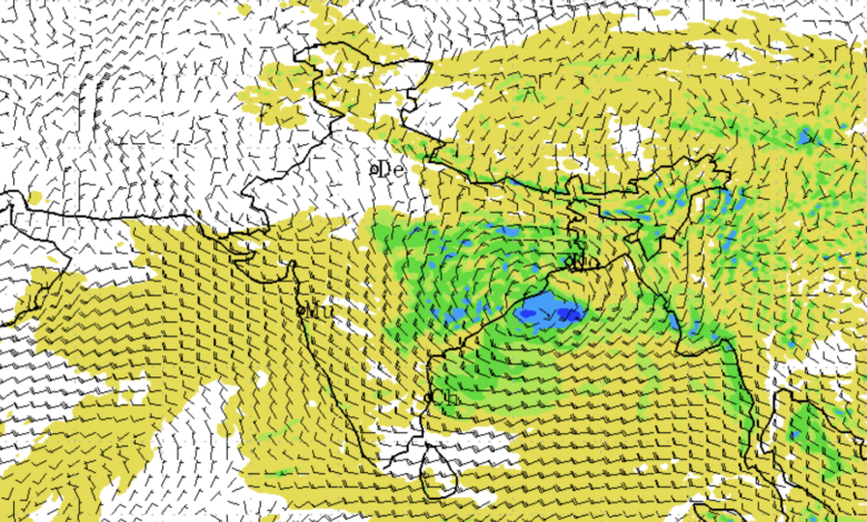
Week 1 anticipates significant features such as the Monsoon Trough positioning itself close to the Himalayan foothills while a low-pressure area forms over the northwest Bay of Bengal. This low-pressure system is forecasted to traverse west-northwestwards towards north Chhattisgarh before evolving into a remnant cyclonic circulation. Expectations of varying degrees of rainfall activity span different regions, with northwest India expecting light to moderate scattered showers and regions like East India experiencing fairly widespread rain and isolated heavy rainfall.
Week 2 anticipates the monsoon trough extending its western end northward while the eastern end relocates to the south. This period foresees a mix of rainfall patterns, with above-normal rainfall projected for East India, near-normal rainfall for the northeast and central India, and below-normal rainfall for northwest and south Peninsular India.
As India navigates the intricacies of its monsoon season, the IMD’s forecasts serve as a crucial tool for stakeholders across sectors, enabling informed decision-making and disaster preparedness. The dynamic interplay of climatic factors remains under constant monitoring as the nation adapts to the ever-evolving weather landscape.


