
Bay of Bengal Low-Pressure System Likely to Become Cyclonic Storm by October 26; Andhra Pradesh, Odisha on Alert
IMD Warns of Heavy to Extremely Heavy Rainfall, Gale-Force Winds and Rough Seas Along East Coast; Fishermen Advised to Return by October 24

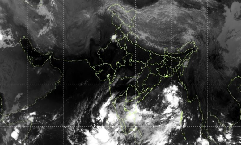
The India Meteorological Department (IMD) has issued a special weather warning after a low-pressure area formed over the east-central and adjoining southeast Bay of Bengal on October 23, 2026. The system is expected to intensify into a depression on October 24, a deep depression on October 25, and a cyclonic storm over the west-central Bay of Bengal by the morning of October 26.
According to the IMD’s Special Message No. 1, the system is likely to continue moving west-northwestwards and intensify further over the following two days, heading towards the north Andhra Pradesh and adjoining south Odisha coasts. The forecast has prompted warnings of heavy rainfall, strengthening winds, deteriorating sea conditions and potential disruptions across the Andaman Islands and the coastal regions of Andhra Pradesh, Odisha and West Bengal.
The IMD issued the bulletin at 10 am IST on October 23, 2026, advising disaster management agencies, state administrations, maritime authorities and other concerned departments to maintain preparedness and closely monitor subsequent forecasts.
Bay of Bengal System: Expected Development
The low-pressure area developed under the influence of an upper-air cyclonic circulation that had prevailed over the southeast and adjoining east-central Bay of Bengal on October 22.
The IMD has outlined the following expected progression:
| Date | Forecast development |
|---|---|
| October 23 | Low-pressure area over the east-central and adjoining southeast Bay of Bengal |
| October 24 | Likely to intensify into a depression |
| October 25 | Likely to strengthen into a deep depression |
| Morning of October 26 | Likely to become a cyclonic storm over the west-central Bay of Bengal |
| October 27–28 | Likely to move west-northwestwards towards north Andhra Pradesh and adjoining south Odisha, with further intensification possible |
The forecast indicates a potentially significant weather system developing over the Bay of Bengal. However, its precise track, intensity and landfall characteristics will depend on subsequent developments and updated IMD forecasts.
Heavy Rainfall Warning for Andhra Pradesh, Odisha and West Bengal
The IMD has warned that rainfall activity is likely to increase progressively as the system intensifies and approaches India’s eastern coastline. While the Andaman Islands are expected to experience rainfall during October 23–25, coastal Odisha, Andhra Pradesh and West Bengal are likely to see increasing rainfall from October 26 onwards.
The most significant rainfall threat is forecast for October 28, when north coastal Andhra Pradesh and adjoining Odisha could receive extremely heavy rainfall at isolated places.
State-wise rainfall forecast
| Region | Forecast period | Expected rainfall |
|---|---|---|
| Andaman Islands | October 23–25 | Light to moderate rain at most places, with heavy rain at isolated places |
| Coastal Odisha | October 26 | Light to moderate rain at many places |
| Coastal Odisha | October 27 | Light to moderate rain at most places, with heavy to very heavy rain at isolated places |
| Coastal Andhra Pradesh | October 27 | Light to moderate rain at most places, with heavy rain at isolated places |
| Coastal Gangetic West Bengal | October 27 | Light to moderate rain at many places, with heavy rain at isolated places |
| North coastal Andhra Pradesh and adjoining Odisha | October 28 | Light to moderate rain at most places, heavy to very heavy rain at a few places and extremely heavy rain at isolated places |
| Coastal areas of West Bengal | October 28 | Heavy to very heavy rain at isolated places |
The forecast for October 28 is particularly important for districts along the north Andhra Pradesh and Odisha coast. Extremely heavy rainfall at isolated locations could cause rapid water accumulation, localised flooding and disruption to road transport.
Coastal districts of West Bengal may also experience heavy to very heavy rainfall as the weather system moves closer to the eastern coast. Residents and local administrations should monitor updated district-level warnings rather than relying solely on the broad regional forecast.
Wind Speeds Likely to Increase as System Intensifies
The IMD has forecast progressively stronger winds over the Bay of Bengal as the low-pressure area develops into a depression, deep depression and potentially a cyclonic storm.
Squally weather is expected over the east-central and adjoining southeast Bay of Bengal, including waters along and off the Andaman Islands. Winds are forecast to strengthen further over the west-central Bay of Bengal by October 26.
| Date | Forecast wind conditions |
|---|---|
| October 23 | 35–45 kmph, gusting to 55 kmph, over the east-central and adjoining southeast Bay of Bengal and along and off the Andaman Islands |
| October 24 | 45–55 kmph, gusting to 65 kmph |
| October 25 | 50–60 kmph, gusting to 70 kmph, over the east-central and adjoining west-central and southeast Bay of Bengal and along and off the Andaman Islands |
| Morning of October 26 | Gale-force winds of 70–80 kmph, gusting to 90 kmph, likely over the west-central and adjoining east-central Bay of Bengal |
| October 27 onwards | Squally weather with winds of 40–50 kmph, gusting to 60 kmph, likely along and off the Andhra Pradesh and Odisha coasts, with a gradual increase thereafter |
The IMD has indicated that winds may strengthen further as the system moves west-northwestwards through October 28. Maritime operators and coastal administrations have been advised to follow subsequent warnings for changes in wind speed and the potential impact on marine operations.