Cyclonic Storm “Mocha” Intensifies into Severe Cyclonic Storm, Prompts Warnings in Bay of Bengal Region
A cyclonic storm named "Mocha," pronounced as "Mokha," has rapidly intensified into a severe cyclonic storm over the southeast Bay of Bengal
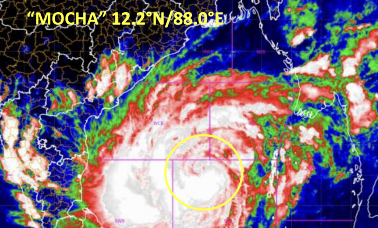
A cyclonic storm named “Mocha,” pronounced as “Mokha,” has rapidly intensified into a severe cyclonic storm over the southeast Bay of Bengal. The storm, which has been moving northwards at a speed of 11 kmph, reached severe cyclonic storm status at 17:30 hours IST on May 11, 2023. Its current position is near latitude 12.2°N and longitude 88.0°E, approximately 520 km west of Port Blair, 1100 km south-southwest of Cox’s Bazar in Bangladesh, and 1020 km south-southwest of Sittwe in Myanmar.
According to the India Meteorological Department (IMD), Cyclone Mocha is expected to continue moving northwards for the next 12 hours, gradually intensifying into a very severe cyclonic storm over the central Bay of Bengal by the morning of May 12. Thereafter, it is projected to gradually recurve and move in a north-northeast direction, gaining further strength. The cyclone is anticipated to make landfall between Cox’s Bazar (Bangladesh) and Kyaukpyu (Myanmar), close to Sittwe (Myanmar), around noon on May 14, 2023. At the time of landfall, it is predicted to be a very severe cyclonic storm, with maximum sustained windspeeds of 150-160 kmph, gusting up to 175 kmph.
Warnings have been issued by the India Meteorological Department regarding the expected impacts of Cyclone Mocha. The following warnings have been outlined:
- Rainfall: Heavy to very heavy rainfall is expected in the Andaman and Nicobar Islands on May 11, with the likelihood of heavy rainfall continuing on May 12. Tripura and Mizoram may experience rainfall at most places, with heavy to very heavy rainfall at isolated locations on May 13 and 14. Nagaland, Manipur, and south Assam may also witness rainfall at many places, with heavy rainfall at isolated areas on May 14.
- Wind: Squally winds with speeds reaching 50-60 kmph, gusting to 70 kmph, are anticipated in the Andaman and Nicobar Islands on May 11. Tripura, Mizoram, and south Manipur are likely to experience squally winds with speeds of 50-60 kmph, gusting to 70 kmph, on May 14.
- Sea Conditions: The sea conditions in the affected regions are expected to be rough to very high. Very rough sea conditions are anticipated in the Andaman Sea on May 11, becoming very rough to rough over the north Andaman Sea on May 12 and 13. The eastcentral Bay of Bengal is expected to experience high to very high sea conditions from May 11 to 12. The westcentral Bay of Bengal may witness very rough to high sea conditions from May 11 to 12, gradually improving thereafter. The northeast Bay of Bengal is likely to have rough to very rough sea conditions on May 12, becoming phenomenal on May 13 and 14. The adjoining areas of the northwest Bay of Bengal may experience rough to very rough sea conditions on May 13 and 14.
- Fishermen Warning: Fishermen, ships, boats, and trawlers are advised not to venture into the southeast Bay of Bengal, adjoining Andaman Sea until May 11, the central Bay of Bengal and north Andaman Sea until May 14.