
Weather Forecast From September 8 Onwards: Rain to Continue Across Several Parts of India

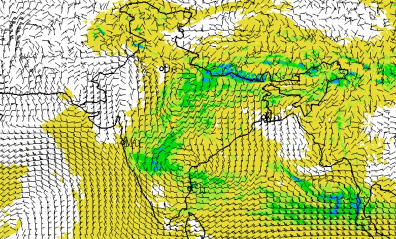
According to the India Meteorological Department (IMD) press release issued on September 7, widespread rainfall activity is expected to continue across several parts of the country from September 8 onwards, with heavy rainfall likely in parts of Uttar Pradesh, Uttarakhand, central India, eastern India and the Northeast.
The latest forecast indicates that while the weather system over Uttar Pradesh will gradually influence rainfall patterns, several other atmospheric systems—including troughs, cyclonic circulations and Western Disturbances—will remain active. The monsoon trough is currently close to its normal position.
Heavy Rainfall Likely Over Uttar Pradesh and Uttarakhand
The most significant weather activity from September 8 is expected over Uttar Pradesh and Uttarakhand.
The IMD has forecast isolated heavy rainfall over East Uttar Pradesh on September 8, while rainfall is expected to remain scattered to isolated over the region during the following days. Uttarakhand is likely to receive isolated to scattered rainfall on September 8 and 9, followed by more widespread rainfall activity during September 10-13. Heavy rainfall is likely over Uttarakhand during September 10-13.
East Uttar Pradesh is also expected to see fairly widespread to widespread rainfall on September 7-8, with isolated to scattered rainfall continuing from September 9 to 13.
West Uttar Pradesh, Haryana, Chandigarh, Delhi, Punjab and East Rajasthan are also expected to experience isolated to scattered rainfall during the period.
Rainfall Activity to Increase Over Central India
Central India is likely to see a gradual increase in rainfall activity after September 8.
The IMD has forecast isolated heavy rainfall over East Madhya Pradesh from September 8 to 11. West Madhya Pradesh is expected to receive isolated to scattered rainfall through September 11, before rainfall becomes fairly widespread to widespread during September 12-13.
East Madhya Pradesh is likely to witness fairly widespread to widespread rainfall from September 9 to 13. Chhattisgarh could also experience a prolonged spell of rainfall, with fairly widespread to widespread activity forecast from September 8 to 13 and isolated heavy rainfall during September 9-13.
Thunderstorms and lightning are also likely across parts of Madhya Pradesh and Chhattisgarh during this period.
Bihar, Jharkhand and West Bengal Face Rain Threat
Eastern India will remain another major zone of rainfall activity from September 8 onwards.
The IMD has forecast fairly widespread to widespread rainfall over Jharkhand from September 8 to 11, while Bihar is expected to receive fairly widespread to widespread rainfall from September 7 to 9. Odisha is likely to see more widespread rainfall during September 10-12.
Of particular significance, isolated heavy rainfall is likely over Bihar from September 8 to 10. Jharkhand could receive isolated heavy rainfall on September 9, while Odisha is likely to experience isolated heavy rainfall on September 8-9 and again on September 11.
Sub-Himalayan West Bengal and Sikkim are also expected to receive isolated heavy rainfall on September 8 and again during September 11-12.
Thunderstorms, lightning and gusty winds are likely in several eastern states. Over Bihar, the IMD has forecast gusty winds of 30-40 kmph, occasionally reaching 50 kmph, during September 7-13. Similar conditions are possible over Jharkhand and Odisha during parts of the forecast period.
Northeast to Remain Rain-Active
The Northeast is also expected to remain under the influence of active weather conditions.
Arunachal Pradesh is likely to experience fairly widespread to widespread rainfall from September 8 through September 13. Assam and Meghalaya are forecast to receive widespread rainfall on September 8 and again during September 12-13.
Nagaland, Manipur, Mizoram and Tripura are likely to receive fairly widespread to widespread rainfall throughout September 7-13.
The IMD has warned of isolated heavy rainfall over Arunachal Pradesh on September 8-9 and again during September 11-13. Heavy rainfall is also likely over Assam and Meghalaya during September 7-13, while Nagaland, Manipur, Mizoram and Tripura could see heavy rainfall during September 7-9 and again during September 11-13.
Thunderstorms and lightning are also likely over several northeastern states.
West India: Konkan and Goa to Receive Widespread Rain
In western India, Konkan and Goa are expected to remain under fairly widespread to widespread rainfall activity throughout September 7-13.
Gujarat, Madhya Maharashtra, Marathwada and Saurashtra and Kutch are likely to experience isolated to scattered rainfall during the same period.
The forecast suggests that rainfall will continue across the western coastal belt even as the overall monsoon activity remains comparatively subdued over parts of peninsular India.
South India: Kerala Rainfall to Intensify
The IMD has forecast isolated to scattered rainfall across large parts of southern India from September 7 to 13.
Kerala and Mahe are expected to see fairly widespread to widespread rainfall from September 10 to 12, with isolated heavy rainfall during the same period.
Lakshadweep is also expected to receive fairly widespread to widespread rainfall on September 10-11.
Thunderstorms and lightning are likely over Tamil Nadu, Puducherry and Karaikal during September 8-11, while South Interior Karnataka may experience thunderstorms and lightning on September 10-11.
Telangana may continue to experience strong surface winds through September 9, while gusty winds of 30-40 kmph, occasionally reaching 50 kmph, are likely during September 7-9.
Delhi Weather: Warm Days, Breezy Conditions
For the national capital, the IMD forecast indicates partly cloudy skies on September 8-10.
On September 8, Delhi’s maximum temperature is expected to remain between 33°C and 35°C, while the minimum temperature could range from 23°C to 25°C. Northwest winds may reach up to 25 kmph during the morning before gradually weakening during the day.
On September 9 and 10, temperatures are expected to remain broadly in the 33°C-35°C range during the day and 24°C-26°C at night. Northwest to westerly winds may remain noticeable, particularly during morning and evening hours.
Weather Systems Driving the Forecast
Several weather systems are contributing to the forecast. The low-pressure area that was earlier located over southwest Uttar Pradesh and adjoining areas had moved over central Uttar Pradesh by the morning of September 7.
A trough extends from south Gujarat towards the cyclonic circulation associated with the low-pressure area. Meanwhile, a Western Disturbance persists as a cyclonic circulation over Kashmir and adjoining areas, while another Western Disturbance is present as an upper-level trough.
Additional cyclonic circulations are located over northeast Bihar and adjoining areas and over west Assam. A separate trough extends from south Telangana towards the Gulf of Mannar.
Rain-Related Risks
The IMD has cautioned that heavy rainfall can affect road and rail traffic, while low-lying areas may experience waterlogging, inundation and localised flooding. In hilly regions, landslides, mudslides and landslips are possible during periods of intense rain.
Strong winds and thunderstorms could also damage vulnerable structures, trees, plantations and standing crops. Lightning remains a significant risk in areas where thunderstorms are forecast.
The latest observations also underline the intensity of the recent spell. During the 24 hours ending 8:30 AM on September 7, exceptionally or extremely heavy rainfall exceeding 20 cm was recorded at isolated places in West Uttar Pradesh, while very heavy rainfall occurred over Uttarakhand, East Uttar Pradesh and Bihar.
Overall Outlook
The September 8-13 period is likely to remain wet across several parts of northern, central, eastern and northeastern India. East Uttar Pradesh, Uttarakhand, East Madhya Pradesh, Bihar, Jharkhand, Odisha, Sub-Himalayan West Bengal, Sikkim and parts of the Northeast are among the areas where heavy rainfall alerts have been indicated for different days.
Meanwhile, Konkan and Goa are likely to maintain widespread rainfall activity, while Kerala could see a fresh increase in rainfall between September 10 and 12. Peninsular India as a whole is otherwise expected to experience comparatively subdued rainfall activity during the next seven days.
Residents in vulnerable areas, particularly low-lying, urban and hilly regions, are advised to monitor official weather warnings and take precautions during heavy rain and thunderstorms. The IMD has specifically advised people to avoid taking shelter under trees during lightning and to move to safer locations if weather conditions deteriorate.