Southwest Monsoon advances into some more parts of South Interior Karnataka and Tamil Nadu, Puducherry & Karaikal; most parts of Bay of Bengal
According to the National Weather Forecasting Centre of the India Meteorological Department:
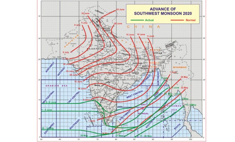
♦ Southwest Monsoon advanced into some more parts of South Interior Karnataka and Tamil Nadu, Puducherry & Karaikal; most parts of southwest Bay of Bengal, entire southeast Bay of Bengal; some more parts of east-central Bay of Bengal and some parts of west-central & northeast Bay of Bengal.
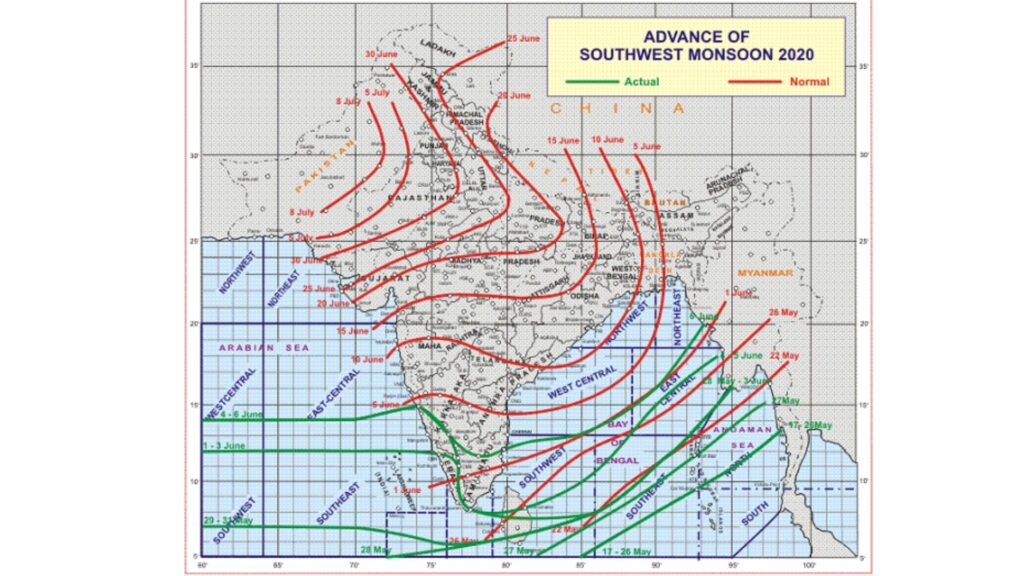
♦ The Northern Limit of Monsoon (NLM) continues to pass through Lat.14°N/Long.60°E, Lat.14°N/Long.70°E, Karwar, Hassan, Salem, Puducherry, Lat.13°N/Long.85°E, Lat.16°N/Long.90°E and Lat.20°N/Long.93°E.
♦ Conditions are becoming favourable for further advancement of Southwest Monsoon into some more parts of Karnataka, entire Tamil Nadu; some parts of Rayalseema and Coastal Andhra Pradesh; entire southwest Bay of Bengal; some more parts of central and northeast Bay of Bengal and some parts of northeast India during next 23 days.
♦ The cyclonic circulation over Bihar & adjoining East Uttar Pradesh extending up to 0.9 km above mean sea level persists.
♦ The Western Disturbance as a trough between 5.8 km and 7.6 km above mean sea level with its axis roughly along Long.78°E to the north of Lat.28°N persists.
♦ The cyclonic circulation over northwest Rajasthan & neighbourhood at 1.5 km above mean sea level persists.
♦ The cyclonic circulation over east Vidarbha & neighbourhood extending up to 0.9 km above mean sea level persists.
♦ The cyclonic circulation over east-central Bay of Bengal & adjoining north Andaman Sea between 3.1 km and 5.8 km above mean sea level persists.
♦ Under the influence of the Western Disturbance, scattered to fairly widespread rain/thundershowers very likely to continue over western Himalayan region and isolated to scattered rain/thundershowers over plains of northwest India during next 48 hours and decrease thereafter. Isolated thunderstorm accompanied with lightning and gusty wind are likely over these regions during next 24 hours.
♦ A Low Pressure Area is likely to develop over East-central Bay of Bengal around 08th June, 2020.