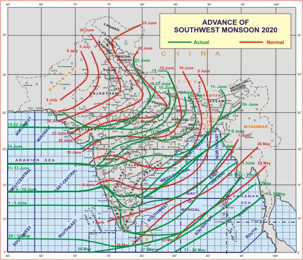
Northern Limit of Monsoon reaches Ahmedabad, Shajapur, Fatehpur and Rudraprayag
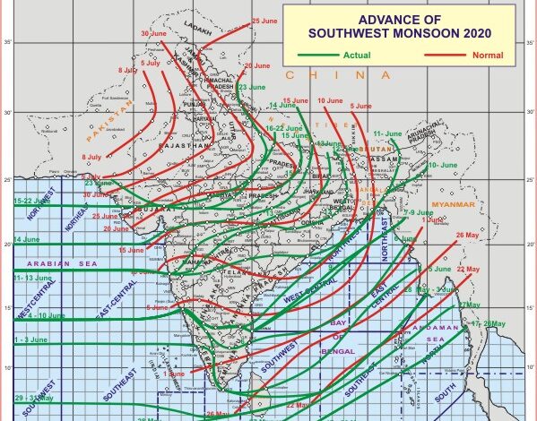
Southwest Monsoon has further advanced into remaining parts of north Arabian Sea, most parts of Kutch, some more parts of Gujarat region, Madhya Pradesh and Uttar Pradesh and some parts of Uttarakhand. The Northern Limit of Monsoon (NLM) now passes through Ahmedabad, Shajapur, Fatehpur and Rudraprayag. Conditions are becoming favourable for further advance of southwest monsoon into remaining parts of Gujarat, Madhya Pradesh, Uttar Pradesh, entire Western Himalayan Region, Haryana, Chandigarh & Delhi, most parts of Punjab and some parts of Rajasthan during next 48 hours.
The cyclonic circulation lies over interior Odisha and neighbourhood between 2.1 km & 5.8 km above mean sea level tilting southwestwards with height.
The trough at mean sea level runs from northwest Rajasthan to northwest Bay of Bengal across northeast Rajasthan, north Madhya Pradesh, northern parts of Chhattisgarh, southern parts of Jharkhand and northern parts of Odisha and extends upto 1.5 km above mean sea level.
Fairly widespread to widespread rainfall with isolated heavy to very heavy rainfall very likely to continue over northeast & adjoining east India during next 5 days. Isolated extremely heavy rainfall is also likely over Sub-Himalayan West Bengal & Sikkim during 25th-26th June and over Assam & Meghalaya during 25th-27th June, 2020.
Fairly widespread to widespread rainfall with isolated heavy to very heavy rainfall likely over parts of south peninsular India during next 5 days. Isolated extremely heavy rainfall also likely over Kerala & Mahe during 26th-27th June.
Fairly widespread to widespread rainfall activity with isolated heavy to very heavy falls also very likely over Uttarakhand and Uttar Pradesh during next 4-5 days. Isolated heavy to very heavy rainfall is also likely over remaining parts of Western Himalayan Region and plains of north west India during 24th-25th June.


