

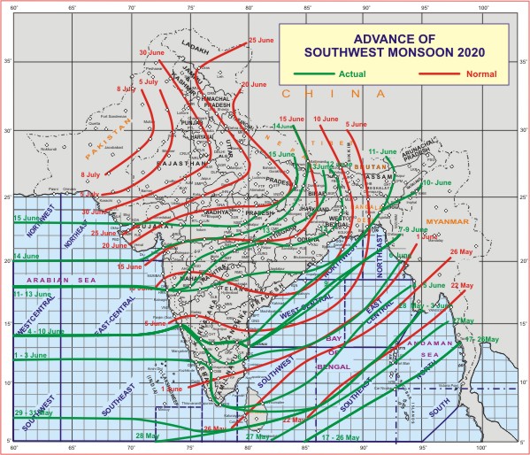
♦ Today, the Southwest Monsoon has further advanced into some more parts of north Arabian Sea, Gujarat state, entire Diu, some more parts of Madhya Pradesh, remaining parts of Chhattisgarh, Jharkhand and Bihar and some parts of East Uttar Pradesh.
♦ Conditions are becoming favourable for further advance of Southwest Monsoon into some more parts of East Madhya Pradesh and East Uttar Pradesh during next 48 hours.

1) An east-west trough runs from northwest Rajasthan to Gangetic West Bengal at lower tropospheric levels and an east-west shear zone is seen from Sub-Himalayan West Bengal to north Konkan across the cyclonic circulation over southeast Uttar Pradesh, south Madhya Pradesh, north Madhya Maharashtra between 3.1 and 5.8 km above mean sea level.
2) Under the influence of above systems, fairly widespread to widespread rainfall very likely to continue over Maharashtra, Chhattisgarh, West Bengal & Sikkim, Odisha, Jharkhand and Bihar during next 2-3 days; Scattered heavy to very heavy falls and isolated extremely heavy falls over Konkan & Goa, isolated heavy to very heavy falls over interior Maharashtra, Sub-Himalayan West Bengal & Sikkim and Odisha and isolated heavy falls over central India and Bihar, Jharkhand and Gangetic West Bengal during next 2-3 days.
3) Widespread rainfall with isolated heavy falls likely to continue over northeast India and scattered to fairly widespread rain with isolated heavy to very heavy rainfall over Gujarat state during next 4-5 days.
4) A Low Pressure Area is likely to form over north Bay of Bengal & neighbourhood around 19th June.