Weather Observed during past 24 hours ending at 0830 hrs IST of today:
Rainfall observed (in cm): Jammu-Kashmir: Anantnag: Anantnag & Amarnath-4 each; Ramban: Banihal-4; Doda: badarwah-3; Kulgam: Qazi Gund-3, Shopian: Zainpora3; Himachal Pradesh: Manali-2; Uttarakhand: Chamoli: Joshimath-2; Uttarkashi: Bhatwari-2.
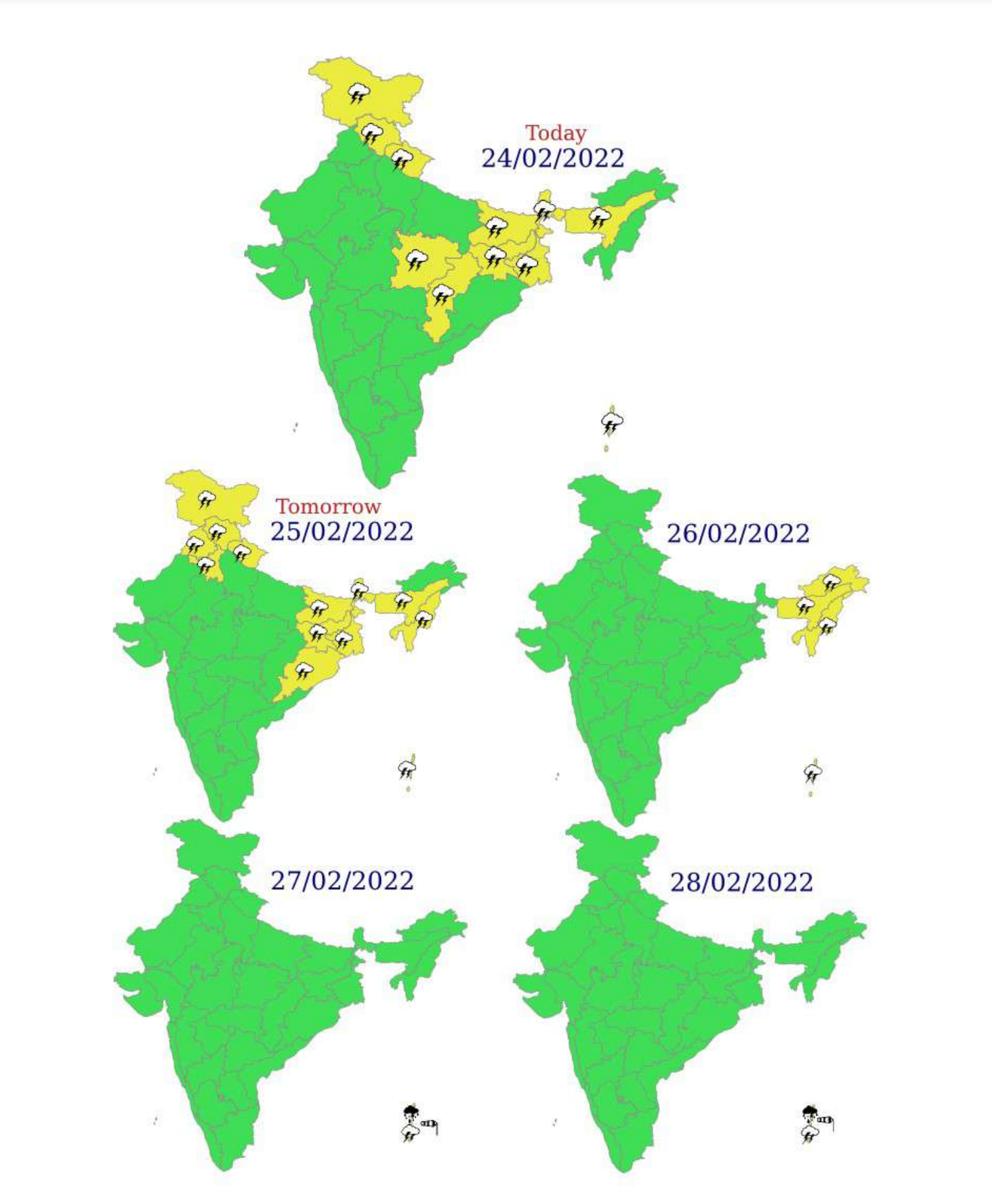
Weather Systems and associated forecast & warnings:
1. A Western Disturbance as a cyclonic circulation lies over north Pakistan & adjoining Jammu & Kashmir at lower tropospheric levels and another Western Disturbance over northeast Afghanistan in middle tropospheric levels.
2. A cyclonic circulation lies over West Madhya Pradesh & adjoining East Rajasthan and a trough runs from this cyclonic circulation to Nagaland in lower tropospheric levels.
Under the influence of above systems:
Scattered to fairly widespread light/moderate rainfall/snowfall with isolated thunderstorm & lightning activity very likely over Jammu-Kashmir-Gilgit-BaltistanMuzaffarabad, Himachal Pradesh and Uttarakhand during next 2 days and isolated rainfall/snowfall during subsequent 2 days. Isolated hailstorm also likely over Uttarakhand during next 2 days.
Isolated to scattered light rainfall very likely over Punjab, Haryana-Chandigarh and West Uttar Pradesh during next 3 days. Isolated light rainfall very likely over Delhi on 25th & 26th February, 2022.
Isolated to scattered light/moderate rainfall with isolated thunderstorm & lightning very likely over Bihar, Jharkhand, Odisha and West Bengal & Sikkim on 24th & 25th February, 2022.
Scattered to fairly widespread rainfall with isolated thunderstorm & lightning over Arunachal Pradesh, Assam & Meghalaya and Nagaland, Manipur, Mizoram & Tripura over the region on 25th & 26th February, 2022. Isolated hailstorm also likely over Assam & Meghalaya during next 2 days.
3. A cyclonic circulation is likely to form over south Andaman Sea & neighbourhood around 27th February, 2022.
Under its influence:
Widespread light/moderate rainfall with isolated heavy falls very likely over Andaman & Nicobar Islands on 27th & 28th February, 2022.
Squally winds (40-50 gusting to 60 Kmph) is very likely over south Andaman Sea on 27th and over south Andaman Sea & adjoining Southeast Bay of Bengal on 28th February, 2022. 4. A fresh Western Disturbance is very likely to influence northwest India from 28th February, 2022. It is very likely to cause scattered to fairly widespread light/moderate rainfall/snowfall over Western Himalayan Region during 28th February to 02nd March, 2022 and isolated light rainfall over adjoining plains of northwest India on 01st & 02nd March, 2022.