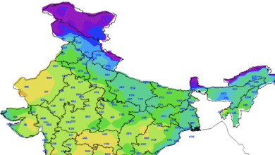
Weather Update: Low Pressure Area in Southeast Bay of Bengal and Arabian Sea Depression

As of 14th October 2024, a low pressure area has been firmly established over the southeast Bay of Bengal, remaining static in the same region as recorded at 2330 hours IST. This weather phenomenon is anticipated to move west-northwest, transitioning into a well-marked low pressure area over the central parts of the south Bay of Bengal by the morning of 15th October. Following this, it is expected to intensify into a depression and continue its trajectory towards the northern Tamil Nadu and Puducherry coasts, along with adjoining areas of south Andhra Pradesh, over the next two days.
Rainfall and Weather Warnings
Heavy Rainfall Forecasts:
- Tamil Nadu and Puducherry: Light to moderate rainfall is predicted across most regions, with heavy to very heavy rainfall likely in isolated areas on 15th October. On 16th October, a few locations in northern Tamil Nadu may experience extremely heavy rainfall. Light to moderate rainfall is also expected in interior Tamil Nadu on 17th October.
- South Andhra Pradesh and Rayalaseema: Similar patterns of light to moderate rainfall will persist, with heavy rainfall expected on 15th and 16th October. Isolated areas may also see extremely heavy rainfall, with heavy rain likely on 17th October.
- Kerala and South Interior Karnataka: Forecasts indicate light to moderate rainfall across most regions, with heavy to very heavy rainfall expected in isolated areas on 16th and 17th October.
Wind Warnings:
- Squally weather conditions are predicted in the southeast and adjoining southwest and central Bay of Bengal, with wind speeds reaching 35-45 km/h, gusting to 55 km/h until the evening of 15th October. Following this, wind speeds may escalate to 40-50 km/h, gusting to 60 km/h over the southwest and adjacent west-central Bay of Bengal and along the Tamil Nadu, Puducherry, and south Andhra Pradesh coasts until the morning of 17th October.
Sea Conditions:
- Moderate to rough sea conditions are anticipated in the southeast and adjacent southwest and central Bay of Bengal through the evening of 15th October, transitioning to rough conditions over the southwest and west-central Bay of Bengal until the morning of 17th October.
Fishermen Advisory
Fishermen are strongly advised against venturing into the southeast and adjoining central Bay of Bengal on 15th October, as well as the southwest and west-central Bay of Bengal from 15th to 17th October. Those currently at sea are urged to return to the coast.
Expected Impacts in Tamil Nadu and Andhra Pradesh
The anticipated heavy rainfall poses several risks, particularly in urban areas, including:
- Localized Flooding: Roads may become inundated, particularly in low-lying areas, potentially leading to closures of underpasses.
- Visibility Issues: Heavy rainfall may reduce visibility, disrupting traffic flow and causing delays.
- Transportation Disruption: Increased travel times and incidents are likely due to waterlogged roads and poor visibility.
- Marine Transportation Challenges: Small boats and trawlers may face disruptions.
- Infrastructure Risks: There may be minor damage to unpaved roads and vulnerable structures.
- Landslides: Areas prone to landslides may experience mudslides and land sinks.
- Agricultural Impact: Standing crops and horticulture could suffer damage from inundation and wind.
Recommended Actions for Residents
Residents in the affected areas are advised to take the following precautions:
- Avoid Travel: Refrain from venturing into areas prone to water logging and stay away from vulnerable structures.
- Monitor Conditions: Regularly check for updates on traffic congestion and heed advisories issued by local authorities.
- Farming Precautions: Provide mechanical support to horticultural crops and ensure harvested produce is stored safely.
Depression Over Westcentral Arabian Sea
In addition to the situation in the Bay of Bengal, a depression has formed over the west-central Arabian Sea, off the Oman coast. As of 14th October at 2330 hours IST, the depression was located at latitude 16.1°N and longitude 61.5°E, approximately 580 km south-southeast of Masirah (Oman) and 800 km east of Salalah (Oman). This weather system is forecasted to move westward towards the Oman coast and is expected to weaken gradually into a well-marked low pressure area within the next 12 hours.
Wind and Sea Conditions:
- Wind Forecast: Squally winds reaching speeds of 40-50 km/h, with gusts up to 60 km/h, are expected over the west-central Arabian Sea until the morning of 16th October, followed by a gradual decrease in intensity.
- Sea Conditions: Rough sea conditions are likely to persist over the west-central Arabian Sea from the night of 14th October until the morning of 16th October.
Fishermen Advisory for Arabian Sea: Fishermen are advised not to venture into the central and adjoining north Arabian Sea until the evening of 14th October and to avoid the west-central Arabian Sea until the morning of 16th October.
Conclusion
Both weather systems—one developing over the southeast Bay of Bengal and the other over the west-central Arabian Sea—present significant challenges. The India Meteorological Department (IMD) is closely monitoring these developments and will provide further updates. The next bulletin will be released at 0830 hours IST on 15th October 2024. Residents in affected regions should remain vigilant and take necessary precautions to ensure safety during this period of severe weather.


