Breaking: IMD Issues Twin Storm Warnings for India’s Coasts
Heavy Rains, Gales Loom Over West & East Shores from Oct 25; Cyclone 'Montha' Nears Bay of Bengal
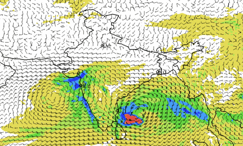
In a stark reminder of the monsoon season’s lingering fury, the India Meteorological Department (IMD) has issued urgent warnings for two intensifying weather systems poised to batter India’s western and eastern coastlines. A depression swirling over the east-central Arabian Sea is advancing northward, while a well-marked low-pressure area in the southeast Bay of Bengal is on the cusp of cyclone formation, potentially earning the name ‘Montha’—a moniker suggested by Thailand—if it escalates as predicted. Authorities urge residents in affected regions to prepare for heavy rains, gale-force winds, and rough seas through the weekend.
The IMD’s National Bulletin No. 14, released at 8:30 PM IST on Friday, paints a picture of escalating risks. The Arabian Sea depression, currently churning at winds of 20 knots (about 37 kmph), is forecast to track north-northeast across the east-central Arabian Sea over the next 24 hours. Meanwhile, the Bay of Bengal system is expected to barrel west-northwest, morphing into a depression by Saturday, a deep depression by Sunday, and a full-fledged cyclonic storm by early Monday—bringing it perilously close to vulnerable shores.
Arabian Sea Depression Targets West Coast
Centred at 15.2°N, 70.7°E as of 5:30 PM IST—roughly 340 km west of Panjim in Goa, 520 km west-northwest of Mangalore in Karnataka, and 490 km south-southwest of Mumbai in Maharashtra—the depression has been drifting north at 15 kmph over the past six hours.
Rainfall Outlook:
- Coastal Karnataka: Light to moderate showers at most spots, with isolated heavy downpours through October 26, escalating to very heavy bursts on the 27th.
- Konkan & Goa: Widespread light to moderate rain, with isolated heavy spells on October 24-25.
- Gujarat: Scattered light to moderate rain along the coast, heavy in isolated areas from October 25-27.
- Lakshadweep Islands: Light to moderate rain with isolated heavy falls today.
- Kerala: Light to moderate showers, heavy to very heavy in isolated pockets today, persisting heavily through October 28.
Wind and Sea Alerts: Squally winds of 45-55 kmph (gusting to 65 kmph) are battering the system’s core in the east-central and adjoining southeast Arabian Sea until October 26. Expect 40-50 kmph gusts (up to 60 kmph) over Lakshadweep, the Comorin area, and off Karnataka-Kerala coasts through the same period, easing slightly to 35-45 kmph (gusts to 55 kmph) off Maharashtra and Gujarat by October 25-26.
Seas will remain rough to very rough in the east-central Arabian Sea until Sunday, with rough conditions off Karnataka, Kerala, and Lakshadweep. Moderate to rough waves are anticipated off Maharashtra and Gujarat over the weekend.
Fishermen are strictly advised to stay ashore in the east-central and southeast Arabian Sea, Lakshadweep-Comorin waters, and along Karnataka-Kerala coasts until October 26, and off Maharashtra-Gujarat from October 25 onward.
Potential Impacts and Safety Measures (Lakshadweep, Kerala, Coastal Karnataka): Heavy rains and gusts could snap tree branches, ravage crops and plantations, and inflict minor damage to thatched homes, walls, and rural roads. Flash floods, landslides, waterlogging, and visibility dips are likely in low-lying areas, disrupting road, rail, and air travel. Small vessels face heightened risks.
Residents should monitor updates closely, seek sturdy shelters (avoiding trees amid lightning threats), unplug electronics during storms, and steer clear of water bodies and conductive objects. Tourism, surface transport, and helicopter operations may face curbs.
Bay of Bengal Low-Pressure Area: ‘Montha’ Looms on Horizon
The southeast Bay of Bengal’s low-pressure zone has upgraded to a well-marked system, with winds already whipping up at 35-45 kmph (gusts to 55 kmph) across the region, Andaman Sea, and east-central Bay fringes.
Forecast models signal rapid intensification: 50-60 kmph squalls (gusts to 70 kmph) over central Bay waters by Saturday, escalating to gale-force 60-70 kmph (gusts to 80 kmph) from Sunday evening through Monday. By October 28-29, winds could howl at 70-80 kmph (gusts to 90 kmph) over the west-central and northwest Bay.
Rainfall Outlook:
- Andaman & Nicobar Islands: Light to moderate rain with isolated heavy spells until October 25.
- Tamil Nadu: Light to moderate showers statewide, heavy in interior districts through October 26 and on the 28th; very heavy on the 27th.
- Andhra Pradesh: Widespread light to moderate rain in interiors through October 29, with very heavy to extremely heavy coastal and Rayalaseema deluges from October 26-28, plus heavy on the 29th.
- Telangana: Light to moderate with isolated heavy rain today and October 27-28.
- Odisha: Light to moderate showers with isolated heavy on October 24 and 26; very heavy from October 27-29.
- West Bengal: Light to moderate rain with isolated heavy from October 28-30.
Wind and Sea Alerts: Coastal gusts of 35-45 kmph (to 55 kmph) will lash Tamil Nadu-Puducherry from October 25-28 and Andhra Pradesh from the 25th onward, intensifying to 45-55 kmph (to 65 kmph) off Andhra by Sunday evening and gales of 60-70 kmph (to 80 kmph) through October 29. Off Odisha, expect 35-45 kmph from October 26, building to 50-60 kmph (to 70 kmph) by October 28-29.
Sea states are moderate to rough now in the southeast Bay, Andaman Sea, and east-central Bay, turning rough to very rough centrally by Saturday and high from Sunday evening. Coasts off Tamil Nadu-Puducherry and Andhra Pradesh will see moderate to rough waves building to very rough-high by late weekend, while Odisha faces similar escalations from October 26.
Fishermen must avoid the southwest-central Bay, and coasts off Tamil Nadu-Andhra Pradesh from October 25, plus Odisha from the 26th.
Potential Impacts and Safety Measures (Andaman & Nicobar, Tamil Nadu, South Interior Karnataka, Andhra Pradesh): Echoing west coast concerns, expect crop losses, structural tweaks to vulnerable buildings, transport snarls, localized flooding, landslides, and visibility hazards. Maritime traffic for small boats will be dicey.
Stay vigilant for deteriorating weather, prioritize safe havens, mitigate lightning risks by disconnecting devices and avoiding electrified zones or water, and brace for transport and tourism halts.
District-specific advisories for Karnataka, Tamil Nadu (including Puducherry and Karaikal), Andhra Pradesh (with Yanam), Odisha, Kerala (plus Mahe), and Lakshadweep are available via IMD portals, urging localized preparations.
The IMD’s next update is slated for 2:00 AM IST on October 25. As these systems evolve, coastal communities from Gujarat to Odisha are on high alert, with disaster response teams like the National Disaster Response Force (NDRF) mobilized. For real-time tracking, visit imd.gov.in or follow official channels. Stay safe, India.