Very Severe Cyclonic Storm “Biparjoy” and Well Marked Low Pressure Area: Weather Updates
Stay Informed About the Latest Cyclonic Developments in the Arabian Sea and Low Pressure Area in the Bay of Bengal
In a recent update, the India Meteorological Department (IMD) has reported significant weather patterns affecting the Arabian Sea and Bay of Bengal. Let’s dive into the details:
A) Very Severe Cyclonic Storm “Biparjoy” over Eastcentral Arabian Sea:
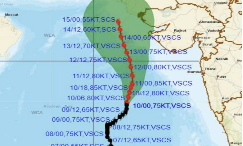
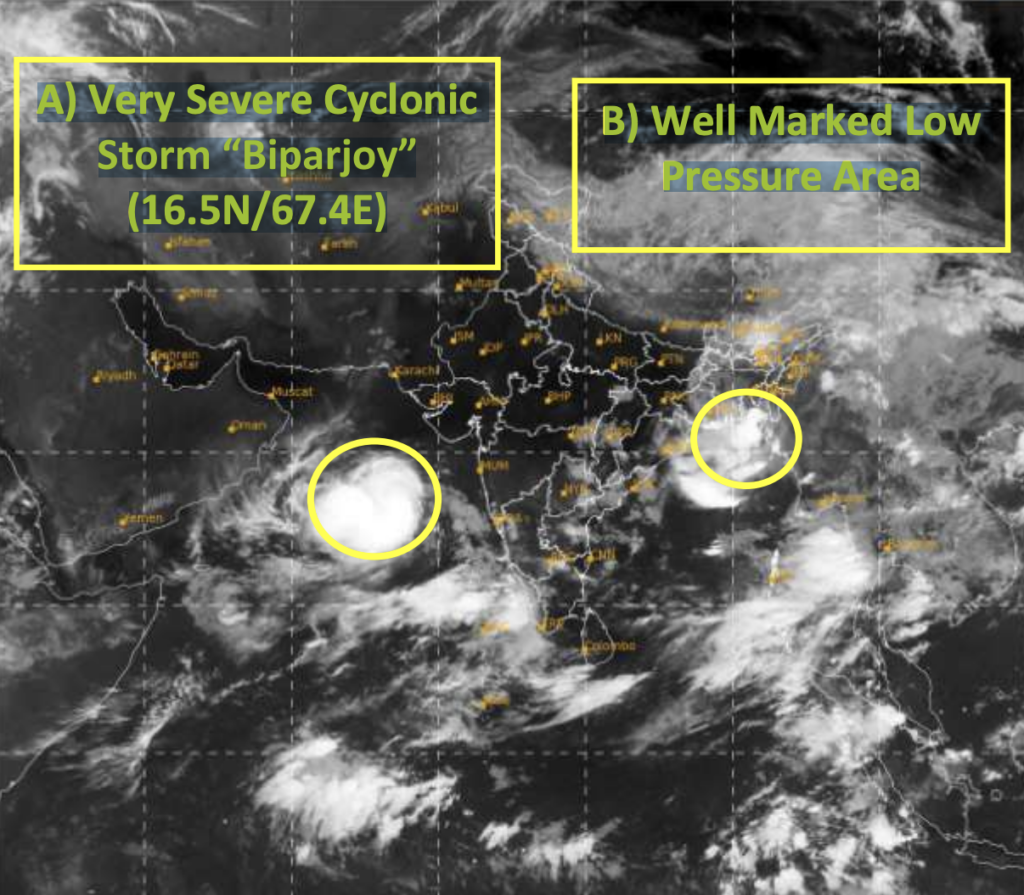
The IMD has identified a very severe cyclonic storm named “Biparjoy” (pronounced as “Biporjoy“) in the eastcentral Arabian Sea. As of 0530 hours IST on June 10, 2023, the storm was centered near latitude 16.5°N and longitude 67.4°E, approximately 700 km west of Goa, 630 km west-southwest of Mumbai, 620 km south-southwest of Porbandar, and 930 km south of Karachi. The storm is expected to intensify further and gradually move in a north-northeast direction over the next 24 hours before turning north-northwestwards.
The IMD has provided a forecast track and intensity for “Biparjoy” as follows:
- June 10, 2023, 0530 IST: 16.5/67.4, Maximum sustained surface wind speed: 135-145 kmph, Category: Very Severe Cyclonic Storm.
- June 11, 2023, 0530 IST: 18.1/67.8, Maximum sustained surface wind speed: 155-165 kmph, Category: Very Severe Cyclonic Storm.
- June 12, 2023, 0530 IST: 19.5/67.7, Maximum sustained surface wind speed: 140-150 kmph, Category: Very Severe Cyclonic Storm.
- June 13, 2023, 0530 IST: 20.7/67.4, Maximum sustained surface wind speed: 135-145 kmph, Category: Very Severe Cyclonic Storm.
- June 14, 2023, 0530 IST: 22.0/67.0, Maximum sustained surface wind speed: 115-125 kmph, Category: Very Severe Cyclonic Storm.
- June 15, 2023, 0530 IST: 23.2/66.8, Maximum sustained surface wind speed: 95-105 kmph, Category: Severe Cyclonic Storm.
The IMD has also issued wind warnings and sea condition alerts for the affected regions. Gale wind speeds, ranging from 135-145 kmph to 155-165 kmph, are expected, accompanied by rough to very high sea conditions.
B) Well Marked Low Pressure Area over Northeast Bay of Bengal:
Additionally, a well-marked low-pressure area has been identified over the northeast Bay of Bengal. The system was located over the Northeast Bay of Bengal and the adjoining areas of Southeast Bangladesh and North Myanmar Coasts as of 0530 hours IST on June 10, 2023.
The IMD has provided the following details regarding the low-pressure area:
- Wind warning: Squally weather with wind speeds of 40-50 kmph, gusting up to 60 kmph, is likely to prevail over the northeast Bay of Bengal on June 10, 2023.
- Sea condition: The sea condition is expected to be rough over the northeast Bay of Bengal on June 10, 2023.
Fishermen in the affected areas are advised to exercise caution and refrain from venturing into the sea until the weather conditions improve.
It is crucial to stay informed about these weather developments and follow the guidance provided by the IMD. Safety precautions, including the suspension of fishing operations and regulation of offshore and onshore activities, should be followed to ensure the well-being of all individuals and industries in the affected regions.