Today Weather System & Forecast

Realised Weather (from 08:30 hours IST of yesterday to 08:30 hours IST of today)
- As predicted, Light to moderate Rainfall/Thundershowers observed: at most places over Jammu & Kashmir and Himachal Pradesh; at many places over Uttarakhand, Punjab, East Uttar Pradesh, Gangetic West Bengal and Jharkhand; at a few places over Bihar, East Madhya Pradesh, Haryana, Chandigarh and Chhattisgarh and at isolated places over West Madhya Pradesh, Vidarbha, West Uttar Pradesh, Odisha, West Rajasthan, Sub-Himalayan West Bengal & Sikkim, Arunachal Pradesh,Telangana and Tamilnadu.
- Rainfall recorded (4 cm or more): Hamirpur- 8; Bilaspur, Nadaun, Bharari, Guler, Nagrota Surian, Nurpur and Aghar- 7 each; Phangota, Sujanpur Tira- 6 each; Baderwah, Naina Devi, Dharmshala, Baldwara, Kasauli- 5 each; Qazigund, Ranjit Sagar Dam sight, Banihal, Batote, Udhampur, Jhandutta, Baijnath, Palampur, Sarkaghat and Umaria- 4 each.
- Heavy rainfall occured at isolated places over Himachal Pradesh.
- Hailstorm observed at isolated places over Jammu & Kashmir, Ladakh, Gilgit-Baltistan (Bhaderwah), Himachal Pradesh (Sundernagar), Uttarakhand (Dehradun), West Rajasthan (Sri Ganganagar), West Uttar Pradesh (Bareilly, Nazibabad), East Uttar Pradesh (Baharaich, Hardoi, Lucknow)

Weather System & Forecast
♦ Yesterday’s ‘Western Depression’ has weakened and now seen as a ‘Western Disturbance’ as a cyclonic circulation over North Pakistan extending upto upper tropospheric levels and an induces cyclonic circulation lies over Haryana in lower levels. Under the influence of above system and interaction between mid-level westerlies and lower level easterlies, following weather is expected:
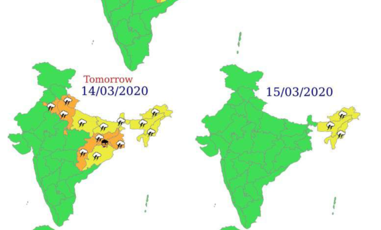
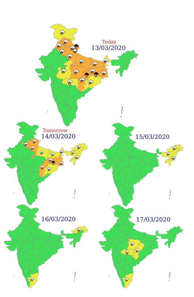
- Light to moderate fairly widespread to widespread rainfall/snowfall is very likely over Jammu,
Kashmir, Ladakh & Gilgit and Baltistan, Himachal Pradesh, Uttarakhand and rainfall over Uttar Prades h on today, the 13th March and it is very likely to decease over the region with scattered to fairly widespread rainfall on 14th March. Isolated to scattered rainfall is also very likely over Punjab and Haryana, Chandigarh & Delhi on today, the 13th March and significant reduction thereafter.
- Isolated heavy rainfall/snowfall is also very likely over Uttarakhand during next 24 hours.
- Thunderstorm accompanied with lightning, hailstorm & squally winds (speed reaching 45-55 kmph occasionally) at isolated places is very likely over Uttarakhand and with lightning, hailstorm & gusty winds (speed reaching 30-40 kmph) over Himachal Pradesh and plains of northwest India during next 24 hours; with lightning over Jammu, Kashmir, Ladakh & Gilgit and Baltistan.
♦ Due to confluence between westerly winds associated with the Western Disturbance and moist low level easterly wind from Bay of Bengal over central & east India, following weather is expected:
1. Moderate scattered to fairly widespread rainfall with isolated thunderstorm, lightning/hail/gusty
wind/squally winds (speed reaching 45-55 kmph occasionally) very likely over East Madhya Pradesh, Chhattisgarh, Jharkhand, Odisha, Bihar and West Bengal & Sikkim during 13th & 14th March. Isolated heavy falls are also likely over north Chhattisgarh on 13th March and over Jharkhand on 13th & 14th March.


