


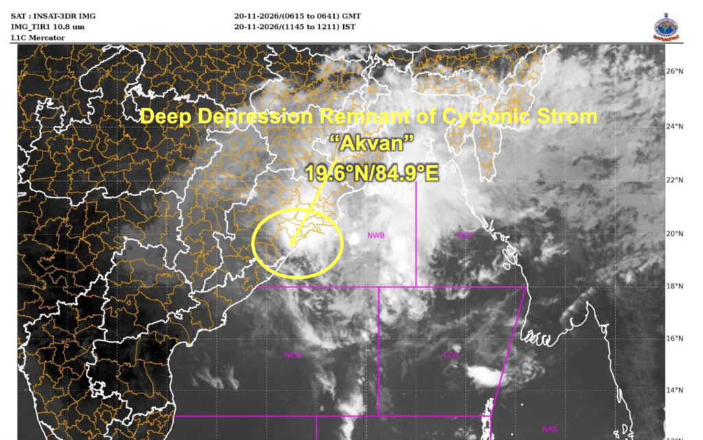
In its National Bulletin No. 39, issued at 1:50 pm IST on November 20, the IMD stated that Akvan had moved north-northeastwards at a speed of approximately 24 kmph during the preceding six hours. The system, which was earlier classified as a cyclonic storm over the north Andhra Pradesh and south Odisha coasts near Gopalpur, has continued to lose intensity.
The latest assessment indicates that the deep depression is likely to move north-northeastwards across Odisha and weaken into a depression during the next six hours. It is further expected to weaken into a well-marked low-pressure area during the subsequent six hours.
Despite the weakening of the system, the IMD has maintained rainfall, wind and marine warnings for several states and coastal regions. Heavy to very heavy rainfall is likely at isolated locations, while moderate flash flood risks have been identified in several watersheds and neighbourhoods of Odisha and Gangetic West Bengal.
The weather system is being continuously monitored through the Doppler Weather Radar at Gopalpur.
Akvan’s Movement and Expected Weakening
According to the IMD’s latest observations, the deep depression was centred near latitude 19.6°N and longitude 84.9°E at 11:30 am on November 20.
Its approximate distance from important coastal locations was as follows:
-
Gopalpur, Odisha: 40 km to the north.
-
Puri, Odisha: 100 km to the west-southwest.
-
Kalingapatnam, Andhra Pradesh: 160 km to the north-northeast.
The IMD has forecast a further north-northeastward movement across Odisha, accompanied by a gradual reduction in wind speed and intensity.
The forecast positions and expected intensity of the system are:
| Date and time (IST) | Forecast position | Wind speed | System intensity |
|---|---|---|---|
| November 20, 11:30 am | 19.6°N, 84.9°E | 55–65 kmph, gusting to 75 kmph | Deep Depression |
| November 20, 5:30 pm | 20.6°N, 85.2°E | 45–55 kmph, gusting to 65 kmph | Depression |
| November 20, 11:30 pm | 21.87°N, 85.3°E | 20–30 kmph, gusting to 40 kmph | Well-Marked Low Pressure Area |
The forecast suggests that the system will gradually lose its organised structure as it moves further inland across Odisha. However, its associated moisture and circulation may continue to influence rainfall over eastern and northeastern India.
Heavy to Very Heavy Rainfall Warning Across Multiple States
The IMD has issued rainfall warnings for Odisha, Chhattisgarh, West Bengal, Jharkhand, Bihar and several northeastern states as the remnants of Cyclone Akvan move inland.
Odisha: Light to moderate rainfall is likely at many places, with heavy to very heavy rainfall at isolated locations on November 20. Coastal and adjoining districts are likely to experience significant weather activity as the system moves across the state.
Chhattisgarh: East Chhattisgarh is likely to receive light to moderate rainfall at many places, with heavy rainfall at isolated locations on November 20 and 21.
Gangetic West Bengal: Light to moderate rainfall is expected at many places, with heavy to very heavy rainfall at isolated locations on November 20. Heavy rainfall at isolated locations is also forecast for November 21.
Sub-Himalayan West Bengal: Light to moderate rainfall is likely at many places, accompanied by heavy rainfall at isolated locations on November 20 and 21.
Jharkhand: Light to moderate rainfall is expected at many places, with heavy to very heavy rainfall at isolated locations on November 20. Heavy rainfall at isolated places is also likely on November 21.
Bihar: Southeast Bihar is likely to receive light to moderate rainfall at many places, with heavy rainfall at isolated locations on November 21.
Northeastern States: Manipur, Tripura, Mizoram and south Assam are likely to experience light to moderate rainfall at many places, with heavy rainfall at isolated locations on November 20. On November 21, similar conditions are forecast over Manipur, Tripura, Mizoram, Assam and Meghalaya.
The IMD has advised authorities and residents in these regions to remain alert, particularly in areas vulnerable to waterlogging, flooding and disruptions caused by heavy rainfall.
Flash Flood Risk in Odisha and Gangetic West Bengal
Apart from the rainfall warnings, the IMD has issued guidance indicating a moderate flash flood risk over a few watersheds and neighbourhoods of Odisha and Gangetic West Bengal during the next 24 hours.
In Odisha, the districts identified for potential flash flood risks include Gajapati, Ganjam, Jagatsinghpur, Kendrapara, Puri, Balasore, Keonjhar, Mayurbhanj, Sambalpur, Sundargarh and Deogarh.
In Gangetic West Bengal, the districts under consideration include Bankura, Purulia, West Midnapore, East Midnapore, Howrah, North 24 Parganas, South 24 Parganas, Hooghly, Nadia and Purba Bardhaman.
The IMD has also highlighted potential flash flood concerns in parts of Jharkhand, including East Singhbhum, Seraikela-Kharsawan, West Singhbhum, Khunti, Ranchi, Simdega and Gumla.
Heavy rainfall over a short period can lead to rapid water accumulation, particularly in low-lying areas, urban neighbourhoods and locations with poor drainage. Authorities have been advised to monitor vulnerable locations and take necessary precautions.
Strong Winds Expected Along Odisha and West Bengal Coasts
Although Cyclone Akvan has weakened into a deep depression, strong winds continue to prevail over parts of the Bay of Bengal and adjoining coastal regions.
According to the IMD, the wind conditions are as follows:
-
Westcentral Bay of Bengal: Squally winds of 50–60 kmph, gusting to 70 kmph, are prevailing and are expected to decrease gradually.
-
Northwest Bay of Bengal: Gale winds of 60–70 kmph, gusting to 80 kmph, are prevailing. These are expected to decrease to squally winds of 40–50 kmph, gusting to 60 kmph, by the evening of November 20.
-
North Andhra Pradesh and Yanam coasts: Squally winds of 50–60 kmph, gusting to 70 kmph, are prevailing and will gradually weaken.
-
South Odisha coast: Gale winds of 60–70 kmph, gusting to 80 kmph, are prevailing. These are expected to reduce to 40–50 kmph, gusting to 60 kmph, by the evening.
-
North Odisha and West Bengal coasts: Squally winds of 45–55 kmph, gusting to 65 kmph, are likely to continue until the evening of November 20 before decreasing.
The IMD has also warned of rough sea conditions in several parts of the Bay of Bengal.
Sea Conditions and Fishermen Advisory
High sea conditions are likely to continue over the northwest Bay of Bengal and along the south Odisha coast for the next three hours from the bulletin’s observation period. Conditions are expected to improve gradually, becoming very rough to rough by the evening.
The westcentral Bay of Bengal and areas along the north Andhra Pradesh coast are also likely to experience very rough to rough sea conditions during the next three hours, followed by gradual improvement.
Along the adjoining north Odisha and West Bengal coasts, rough sea conditions are likely to persist until the evening of November 20.
The IMD has advised fishermen not to venture into the westcentral Bay of Bengal until the night of November 20 and the northwest Bay of Bengal until the morning of November 21.
Fishing operations have been advised to remain suspended in the affected marine areas. Fishermen have been urged to follow the latest area-specific weather advisories before planning any activities.
IMD Warns of Possible Damage to Roads, Railways and Infrastructure
The IMD has cautioned that the weather system could cause disruptions to transport infrastructure and essential services across Odisha, West Bengal, Jharkhand, Bihar, Chhattisgarh and northeastern states.
Potential impacts include damage to kutcha and pucca roads, flooding of escape routes, waterlogging in low-lying areas and disruption of traffic in major cities. Urban flooding could increase travel times and affect the movement of essential services.
The weather agency has specifically highlighted the possibility of disruptions to:
-
Railway operations, overhead power lines and signalling systems.
-
Road transportation due to waterlogging and localised flooding.
-
Airports and heliports.
-
Drinking water and sanitation facilities.
-
Coastal infrastructure and vulnerable residential structures.
For north Odisha, Gangetic West Bengal, south Jharkhand and east Chhattisgarh, the IMD has additionally warned of possible damage to thatched and kutcha houses, as well as vulnerable tin-roofed and asbestos-roofed structures.
Flooding could also result in breaches in kutcha roads and affect access to essential services.
The possibility of riverine flooding, urban flooding, coastal flooding and landslides in hilly areas has also been highlighted as a secondary hazard.
Authorities Asked to Regulate Transport and Ensure Public Safety
In view of the expected weather conditions, the IMD has advised authorities to regulate rail, road and air traffic judiciously. Transport operators and passengers have been asked to remain alert to local advisories and changing weather conditions.
People have been advised to check traffic conditions before beginning their journeys and avoid travelling through locations that frequently experience waterlogging.
Coastal hutment dwellers in vulnerable locations should be moved to safer places, while residents in affected areas have been advised to remain indoors during adverse weather conditions. People have also been cautioned against staying in vulnerable structures.
The movement of motorboats and small ships has been described as unsafe under the prevailing sea conditions.
The IMD has further advised suspension of offshore and onshore operations where necessary. Dam and reservoir authorities have been asked to assess prevailing conditions and monitor water levels.
Fisheries departments and fishing harbour authorities have been advised to alert fishermen and follow subsequent marine weather warnings. Shipping companies, port operators and offshore establishments have also been asked to review their operational preparedness.
Maritime authorities have been advised to review communication arrangements, vessel tracking systems and search-and-rescue preparedness, particularly for vessels operating in areas likely to be affected.
Cyclone Akvan’s Weakening Does Not End Weather Concerns
The weakening of Cyclone Akvan into a deep depression marks a significant reduction in the system’s intensity. However, the IMD’s latest bulletin indicates that rainfall, flooding and strong wind-related risks will continue across several eastern and northeastern states.
The system is expected to weaken further into a depression by the evening of November 20 and subsequently become a well-marked low-pressure area by late Friday night.
While wind speeds are forecast to decrease gradually, heavy rainfall and associated flooding remain important concerns, particularly in Odisha, Gangetic West Bengal and adjoining regions.
The IMD is continuing to monitor the system through the Gopalpur Doppler Weather Radar and has stated that its next bulletin will be issued at 5:30 pm IST on November 20.
Authorities and residents have been advised to follow official weather warnings and take appropriate precautions until conditions improve.