
IMD Issues Heavy Rainfall Alert for Tamil Nadu, Kerala and Puducherry; Kashmir Likely to Receive Rain and Snowfall on November 12

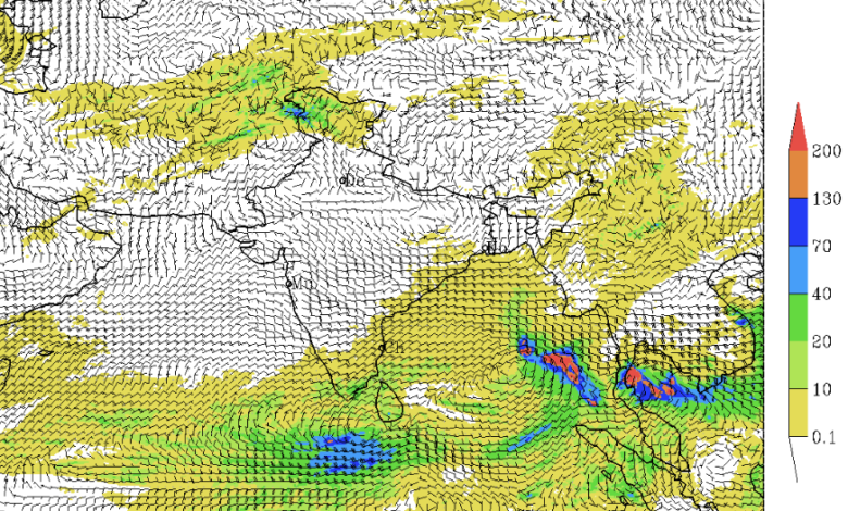
Heavy Rainfall Forecast for Tamil Nadu Between November 8 and 10; Andaman and Nicobar Islands May Witness Heavy Rain from November 9 to 13; Moderate Fog Likely in Delhi-NCR Over the Next Few Days
The India Meteorological Department (IMD) has issued a weather alert for several parts of the country, forecasting heavy rainfall, thunderstorms, lightning and gusty winds across southern, eastern and northeastern India over the next few days. Tamil Nadu, Puducherry and Karaikal are likely to experience isolated heavy rainfall between November 8 and 10, while Kerala, Mahe and Lakshadweep have also been placed under a heavy rainfall warning for November 8.
In its national weather bulletin issued on November 8, 2026, the IMD further warned that Jammu and Kashmir, including the adjoining Himalayan region, could receive heavy rainfall or snowfall on November 12 under the influence of an approaching Western Disturbance.
The weather department has also forecast heavy rainfall over the Andaman and Nicobar Islands between November 9 and 13, while isolated heavy showers are likely over Nagaland, Manipur, Mizoram and Tripura on November 11.
The IMD has advised residents, farmers, fishermen and authorities in vulnerable regions to remain alert and take precautionary measures, particularly in areas susceptible to waterlogging, flooding, landslides and strong winds.
Heavy Rainfall Warning for Tamil Nadu, Kerala and Puducherry
Southern India is expected to experience significant rainfall activity on November 8, with fairly widespread to widespread rainfall likely over Kerala, Mahe, Lakshadweep, Tamil Nadu, Puducherry and Karaikal.
According to the IMD, isolated heavy rainfall is likely over Tamil Nadu, Puducherry and Karaikal during November 8-10. Kerala, Mahe and Lakshadweep may also receive heavy rainfall on November 8.
The department reported that Tamil Nadu had already recorded heavy rainfall during the 24-hour period ending at 8:30 am on November 8. Chennai received 10 cm of rainfall, making it one of the locations with significant precipitation during this period.
Rainfall activity is expected to continue in parts of southern India until November 14, although its intensity and geographical distribution may vary.
Isolated to scattered rainfall is likely over Kerala, Mahe, Lakshadweep and Tamil Nadu, Puducherry and Karaikal during November 9-14. Coastal Andhra Pradesh and Yanam, Rayalaseema and South Interior Karnataka may also experience rainfall during this period.
Thunderstorms accompanied by lightning and gusty winds are likely over Coastal Andhra Pradesh, Yanam, Kerala, Mahe, Lakshadweep, Rayalaseema, Tamil Nadu, Puducherry and Karaikal between November 8 and 10.
Wind speeds may reach 30-40 kmph, with gusts up to 50 kmph. Strong surface winds are also expected over Coastal Andhra Pradesh, Yanam and Rayalaseema during November 8-10.
The IMD has advised people in affected areas to avoid taking shelter under trees during thunderstorms and to stay away from water bodies and electrical installations.
Western Disturbance to Bring Rain and Snowfall in Kashmir
The northwestern Himalayan region is likely to witness a fresh spell of unsettled weather from November 10 onwards due to an approaching Western Disturbance.
The IMD has indicated that a fresh Western Disturbance is likely to affect the northwestern Himalayan region from November 10.
Under its influence, isolated to scattered rainfall or snowfall is forecast over Jammu and Kashmir, Ladakh, Gilgit-Baltistan and Muzaffarabad during November 10-11 and again on November 14.
The most significant precipitation activity is expected on November 12 and 13, when fairly widespread to widespread rainfall or snowfall is likely over the region.
The weather department has specifically forecast isolated heavy rainfall over Jammu and Kashmir, Ladakh, Gilgit-Baltistan and Muzaffarabad on November 12.
Thunderstorms accompanied by lightning and gusty winds are also likely between November 10 and 14. Wind speeds may reach 40-50 kmph, with gusts reaching 60 kmph.
Himachal Pradesh is likely to experience isolated to scattered rainfall between November 11 and 14, with thunderstorms and lightning possible on November 12 and 13.
Uttarakhand may receive isolated to scattered rainfall between November 8 and 10, followed by another spell during November 13-14.
Punjab is also likely to witness isolated rainfall between November 12 and 14.
The IMD has advised residents and travellers in hilly areas to remain cautious because heavy precipitation may trigger landslides, mudslides, road blockages and temporary disruptions to transport services.
Heavy Rain Forecast for Andaman and Nicobar Islands
The Andaman and Nicobar Islands are likely to experience an extended period of rainfall activity between November 8 and 14.
The IMD has forecast fairly widespread to widespread rainfall across the islands during this period, with isolated heavy rainfall likely between November 9 and 13.
The department has advised farmers and residents to take precautionary measures against waterlogging and strong winds.
Rainfall accompanied by thunderstorms and gusty winds could affect agricultural activities, marine operations and transportation.
Northeast India to Witness Thunderstorms and Heavy Rain
Several northeastern states are also expected to receive rainfall during the coming days.
According to the IMD, isolated to scattered rainfall is likely over Arunachal Pradesh, Assam and Meghalaya between November 9 and 12.
Nagaland, Manipur, Mizoram and Tripura may experience rainfall between November 9 and 13.
The department has issued a specific heavy rainfall warning for Nagaland, Manipur, Mizoram and Tripura on November 11.
Meanwhile, eastern India is likely to experience scattered rainfall activity in several states.
Gangetic West Bengal and Sub-Himalayan West Bengal, along with Sikkim, may receive isolated to scattered rainfall between November 9 and 12.
Jharkhand is likely to experience rainfall on November 10 and 11, Bihar on November 11, and Odisha between November 10 and 12.
The IMD has not forecast any significant weather activity over western and central India during the coming week.
Delhi-NCR Weather: Fog Likely to Affect Morning Visibility
The national capital is likely to experience mainly clear to partly cloudy skies over the next four days, accompanied by shallow to moderate fog during morning and night hours.
According to the IMD’s Delhi-NCR forecast issued on November 8, maximum temperatures in the national capital have remained between 28°C and 31°C, while minimum temperatures have ranged from 16°C to 17°C.
Minimum temperatures were appreciably above normal at isolated places, by 3.1°C to 5°C, while maximum temperatures were below normal at some locations by 1.6°C to 3°C.
Shallow fog was reported at Safdarjung and Palam airports on the morning of November 8.
At Safdarjung, visibility dropped to 700 metres between 6:30 am and 8:30 am before improving to 900 metres. At Palam, visibility fell to 800 metres between 7:30 am and 8 am and subsequently improved to 900 metres by 8:30 am.
The IMD has forecast the following weather conditions:
-
November 8: Mainly clear sky, with shallow fog likely at many places during the night. Maximum temperature is expected to remain between 29°C and 31°C.
-
November 9: Partly cloudy sky, with moderate fog at most places during morning hours. Maximum and minimum temperatures are likely to range between 28°C and 30°C and 15°C and 17°C, respectively.
-
November 10: Partly cloudy conditions with moderate fog at most places in the morning. Maximum temperature may range between 27°C and 29°C, while minimum temperature is likely to remain between 14°C and 16°C.
-
November 11: Partly cloudy sky, with shallow to moderate fog at most places during morning hours. Maximum and minimum temperatures are likely to remain between 27°C and 29°C and 14°C and 16°C, respectively.
The IMD has advised commuters to remain cautious during early morning hours, particularly around areas where fog may reduce visibility.
Strong Winds and Heavy Rain May Affect Transport and Agriculture
The weather department has cautioned that heavy rainfall accompanied by gusty winds could cause damage to trees, crops, temporary structures and infrastructure.
According to the IMD, strong winds may break tree branches and uproot smaller trees, including banana, papaya and drumstick plants.
Standing crops, plantations and horticultural activities may also suffer damage. Vulnerable structures, kutcha houses, huts and boundary walls could sustain partial damage.
Heavy rainfall may lead to localised waterlogging, inundation and flooding in low-lying areas. Hilly regions could experience landslides, mudslides and road blockages.
Road and railway traffic may be affected by heavy rainfall and squally winds. Reduced visibility could also disrupt transportation and helicopter services.
The IMD has further warned that small ships, fishing boats and trawlers could be affected by adverse weather conditions.
Tourism and recreational activities in vulnerable areas should be regulated, while onshore and offshore operations should be undertaken with appropriate precautions.
IMD Issues Agricultural Advisories for Farmers
The weather department has issued region-specific agricultural advisories to minimise crop losses.
In Tamil Nadu, farmers have been advised to ensure adequate drainage in rice, maize and casuarina fields and remove excess water from agricultural land. Banana plantations should be provided with mechanical support, while drainage channels in sugarcane fields should be opened to prevent waterlogging around plant roots.
In Kerala, farmers have been advised to maintain proper drainage in standing crop fields. Transplantation of rabi rice should be undertaken only when field conditions are suitable.
Banana and papaya plantations should be supported, while young plants and vegetables should be properly staked to minimise damage from gusty winds.
In the Andaman and Nicobar Islands, farmers have been advised to ensure proper drainage in crop fields and nurseries. Mature rice and vegetables should be harvested during rain-free intervals, and harvested produce should be dried under cover.
Farmers have also been advised to avoid applying fertilisers and pesticides during rainfall.
The IMD has recommended shifting harvested produce to safer locations or covering it with tarpaulin sheets to prevent damage from strong winds.
Advisory for Livestock, Poultry and Fisheries
The IMD has also issued precautionary guidelines for livestock owners, poultry farmers and fisheries operators.
Animals should be kept inside sheds during heavy rainfall and provided with balanced feed. Feed and fodder should be stored in safe, dry locations to prevent spoilage.
Fish farmers have been advised to construct properly netted outlets around ponds to drain excess water while preventing fish from escaping during overflow.
IMD Advises People to Remain Alert
The IMD has urged people in areas covered by heavy rainfall and thunderstorm warnings to regularly monitor weather updates and be prepared to move to safer locations if conditions deteriorate.
People should avoid taking shelter under trees during thunderstorms. Electrical and electronic appliances should be unplugged whenever lightning is expected, and people should immediately move away from water bodies and objects that conduct electricity.
Tourism, recreational activities, marine operations and helicopter services should be regulated according to prevailing weather conditions.
The department has also emphasised that vulnerable urban and hilly areas require special attention during heavy rainfall warnings.
The IMD has clarified that forecast accuracy generally decreases as the lead period increases. Therefore, residents and local authorities should follow updated district-level weather warnings rather than relying solely on long-range forecasts.
Detailed district-wise multi-hazard warnings and updates are available on the IMD website.
Official IMD Weather Resources:
-
National Weather Bulletin: https://mausam.imd.gov.in/responsive/all_india_forcast_bulletin.php
-
District-wise Weather Warnings: https://mausam.imd.gov.in/responsive/districtWiseWarningGIS.php
-
Fishermen Weather Warnings: https://rsmcnewdelhi.imd.gov.in/fishermenwarning.php