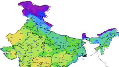
Current Weather Status and Extended Range Forecast (October 17-30, 2024)

Observed Weather Features (Week Ending October 16, 2024)
The Southwest Monsoon officially withdrew from across India on October 15, marking a transition to the Northeast Monsoon, which commenced its rainfall activity over Southeast Peninsular India on the same day.
Key Developments:
- Depression in the Arabian Sea: A low-pressure area formed over Lakshadweep and the adjoining Arabian Sea on October 9, evolving into a well-marked low pressure by October 10. This system intensified into a depression in the central Arabian Sea by October 13 and made landfall near Duqm, Oman, during the night of October 15.
- Depression in the Bay of Bengal: A low-pressure area formed in the Southeast Bay of Bengal on October 14, which strengthened into a depression on October 15. This system led to heavy rainfall in parts of North Coastal Tamil Nadu and Rayalaseema on October 16.
- Rainfall Patterns: Significant rainfall was recorded across various regions:
- Sub-Himalayan West Bengal & Sikkim, Tamil Nadu, and Puducherry saw very heavy rainfall on October 10.
- Konkan and Goa reported heavy rainfall on October 11, while Kerala and North Interior Karnataka experienced heavy rainfall on October 12.
- Subsequent days saw heavy rains across Tamil Nadu, Coastal Andhra Pradesh, and Madhya Pradesh.
- Temperature Trends: Minimum temperatures were 1-3°C above normal across central and western India, while maximum temperatures were below normal in the southern, northeastern, and western regions. The highest recorded maximum temperature was 39.6°C in Sri Ganganagar, Rajasthan, on October 16, while the lowest minimum was 15.4°C in Delhi Ridge on October 15.
- Rainfall Distribution: The all-India weekly rainfall departure from the long-period average (LPA) stood at +43%. However, the cumulative seasonal rainfall from October 1-16 showed a deficit of 3%.
| Region | Week Actual | Week Normal | % Departure | Season Actual | Season Normal | % Departure |
|---|---|---|---|---|---|---|
| East & Northeast India | 26.2 mm | 26.8 mm | -2% | 97.2 mm | 85.9 mm | +13% |
| Northwest India | 1.6 mm | 5.8 mm | -73% | 4.1 mm | 14.6 mm | -72% |
| Central India | 21.2 mm | 13.0 mm | +63% | 28.6 mm | 40.6 mm | -30% |
| South Peninsula | 61.5 mm | 32.1 mm | +92% | 103.8 mm | 83.3 mm | +25% |
| Country Total | 23.9 mm | 16.7 mm | +43% | 46.8 mm | 48.2 mm | -3% |
Large-Scale Features
Current observations indicate neutral El Niño-Southern Oscillation (ENSO) conditions in the equatorial Pacific, with below-average sea surface temperatures. There is an increased likelihood of La Niña conditions developing during the post-monsoon season of 2024.
In the Indian Ocean, above-average sea surface temperatures are prevalent, and neutral Indian Ocean Dipole (IOD) conditions are expected to persist through the end of the monsoon season.
The Madden-Julian Oscillation (MJO) index is currently in Phase 3 and is projected to progress eastward into Phases 4, 5, and 6 over the coming weeks.
Two-Week Forecast (October 17-30, 2024)
Week 1 (October 17-23):
- A well-marked low pressure area is present over South Coastal Andhra Pradesh, with an associated cyclonic circulation. This system is expected to weaken into a low pressure area within the next six hours.
- A fresh upper air cyclonic circulation is likely to develop over the North Andaman Sea around October 20. A low pressure area may form over the Central Bay of Bengal by October 22 and could intensify into a depression by October 24.
Precipitation Forecasts:
- South Peninsular India:
- Widespread light to moderate rainfall is expected over Kerala, Lakshadweep, and Karnataka. Tamil Nadu, Puducherry, Coastal Andhra Pradesh, and Rayalaseema may also see scattered rainfall.
- Heavy rainfall is anticipated in Tamil Nadu on October 18, 20, and 21, as well as in South Interior Karnataka during October 17-22.
- West India:
- Scattered rainfall is expected over Konkan and Goa, with isolated heavy rainfall likely on October 17 and again on October 20-21 in Gujarat.
- Northwest and Central India:
- No significant rainfall is anticipated in these regions during this week, which may lead to a dry spell.
Overall Rainfall Outlook: Rainfall is expected to be normal to above normal across much of Central and East Peninsular India, while below-normal rainfall is forecasted for the rest of the country.
Week 2 (October 24-30):
- A depression is expected to form over the Central Bay of Bengal, leading to widespread rainfall in East and Northeast India.
- A Western Disturbance may bring light isolated rain and snow to the Western Himalayan Region.
Expected Rainfall Patterns:
- East and Northeast India: Scattered to widespread rainfall with isolated heavy falls are likely in the first half of the week.
- Western Himalayan Region: Rainfall/snowfall is expected due to the Western Disturbance.
General Rainfall Predictions: Rainfall in East and Northeast India is likely to be normal to above normal, near normal in Northwest India, and below normal across the remaining regions.
Conclusion
The current weather status reveals significant rainfall activity, particularly in the Southern and Eastern regions of India. As we move into the next two weeks, the development of new weather systems will likely continue to influence rainfall patterns across the country. Residents are advised to stay updated on forecasts, particularly those in flood-prone areas.


